Phase II Archaeological Assessment of Sites 44JC1040 and 44JC1041 within the Proposed Colonial Williamsburg Bus Facility
Colonial Williamsburg Foundation Library Research Report Series - 0402
Colonial Williamsburg Foundation Library
Williamsburg, Virginia
2009
Phase II Archaeological Assessment of Sites 44JC1040 and 44JC1041 within the Proposed Colonial Williamsburg Bus Facility
The Colonial Williamsburg Foundation
Department of Archaeological Research
P.O. Box 1776
Williamsburg, VA 23187-1776
(757) 220-7330
Mark Kostro
Project Archaeologist
Marley R. Brown III
Principal Investigator
June 2001
Management Summary
Between July 25 and September 1, 2000, the Colonial Williamsburg Foundation's Department of Archaeological Research (D.A.R.) conducted a Phase II archaeological assessment of two sites (44JC1040 and 44JC1041) southeast of Colonial Williamsburg's Historic Area, along Route 60. The sites are in Williamsburg, located on property currently owned by the Colonial Williamsburg Foundation. The sites were originally identified during a 1999 archaeological survey by Colonial Williamsburg Foundation archaeologists (Kostro 2000), in anticipation of the development of the property by the Foundation. Phase II archaeological assessments were recommended for each of the sites prior to any alterations to the property. The primary goals of the Phase II assessment were to delineate the boundaries of two of the previously identified sites, to better define their respective periods of occupation, and to determine the integrity and significance of each of the sites' preserved remains.
The Phase II archaeological assessment consisted of the excavation of a total of one hundred five 75-cm-square test units across the two sites. In general, tests were regularly spaced, at 10-meter intervals. When time constraints permitted, additional tests were excavated at varying collapsed intervals to more thoroughly explore certain features. Each test unit was stratagraphically excavated to undisturbed subsoil, and all excavated soils were passed through ¼-inch mesh screens. All artifacts recovered were retained for laboratory analysis. Detailed descriptions of the stratigraphy were recorded for each test unit, including thickness, soil type, and soil color. Features exposed within the test units were also recorded, but not excavated—with one exception. Each feature was mapped, photographed, and described in detail.
44JC1040
A multi-component site, 44JC1040 contains evidence of both colonial and Native American occupations. The site is located on top of a raised terrace that extends north and west and eventually terminates at a ravine that drains west into Tutter's Neck Pond. The Phase I results indicated that 44JC1040 was a domestic site occupied from the late seventeenth to the early eighteenth century. In the course of the Phase II fieldwork, a previously undetected Middle to Late Archaic (8500-3200 BP) Native American component was also identified within the site boundaries.
The late seventeenth through early eighteenth-century occupation of the site was established through the recovery of a large quantity of artifacts dating to that time period, as well as the discovery of a small number of intact features. Analysis of the distribution of the seventeenth- and eighteenth-century artifacts from across the site revealed two distinct concentrations within the site boundaries. The presence of a large number of architecturally related artifacts within these two concentrations further suggests that buildings once existed at both locations. Several intact features relating to the structures were also identified. These include a possible root cellar, a ditch or trench, and several post holes. The distinctive pit resembles those found on domestic sites both in the local area and elsewhere in the Tidewater.
iiThe previously-unidentified Archaic-period Native American component of 44JC1040 is characterized by a light scatter of artifacts, including two projectile points, one scraper, lithic debitage, and fire cracked rock. No features believed to be associated with the Native American occupation were identified.
Site 44JC1040 is a multi-component site with evidence of both colonial and Native American occupations. Artifacts associated with each of these occupations were recovered in significant quantities from test units within the site's boundaries. Although the area has been plowed, intact sub-surface features associated with the colonial period occupation of the site were also identified and recorded, and attest to the site's good state of preservation. The results of the Phase II assessment shows that 44JC1040 is the remains of an early colonial plantation site. This association makes the site highly significant in terms of the criteria of National Register of Historic Places. As a result, if there exists no options for site avoidance, a Phase III data recovery excavation of Site 44JC1040 will be necessary prior to any further alteration to, or construction on, the property.
44JC1041
A large multi-component site, 44JC1041 contains evidence of four distinct components within the site boundaries, two historic (Loci 1 and 2) and two prehistoric (Loci 3 and 4). Each component was established on the basis of artifact clusters of similar age. The first three loci were identified during the Phase I survey; the fourth locus was identified in the course of the Phase II assessment.
Locus 1 represents the late seventeenth-century domestic occupation of the site. It is located within a gully descending from south to north into the deep ravine that eventually drains west into Tutter's Neck Pond. The locus was identified based on variety of middle to late seventeenth-century artifacts recovered primarily from silt layers within the gully. The soil layers containing the seventeenth-century material resulted from the erosion of the surrounding terraces. Locus 1 represents merely the secondary deposition of the artifacts. The point of origin of the artifacts, or source of the artifacts, lies atop of one of the surrounding eroding terraces. Scant traces of potential sources of the seventeenth-century material were revealed on top of the terraces to the southeast and west of Locus 1. These areas probably contain the structures associated with the material found in the ravine. The site may be the remains of a seventeenth-century slave quarter or the home of an English born indentured servant/tenant.
Locus 2 consists of a mid-eighteenth-century domestic occupation. Locus 2 is located northeast of Locus 1, on top of a narrow flat terrace. The locus was characterized by small cluster of mid-eighteenth century artifacts, and a heavy concentration of brick. Several features relating to a possible structure were also identified at the site, including a possible chimney base, postholes, and a large feature of an undetermined function. It is possible that this site is the remnants of a mid-eighteenth century slave quarter.
Locus 3 is a Native American seasonal procurement camp, dating to Middle Woodland period (2500-1100 BP). The locus is located northwest of Locus 1, on top of a flat terrace overlooking a ravine that drains west into Tutter's Neck Pond. Artifacts recovered from within the locus consisted primarily of a large number of Native American pottery fragments, a complete projectile point, and the tip of another projectile point. A small iii quantity of lithic debitage and fire-cracked rock was also recovered from the area. In addition to the artifacts, several small features possibly related the site's Native American occupation were also identified and recorded.
Locus 4 is another Native American seasonal procurement camp dating to the Middle Woodland period (2500-1100 BP), although it is much smaller than Locus 3. A gully separates the two seemingly contemporary Native American sites at Loci 3 and 4. The locus is situated at the northern tip of flat narrow terrace overlooking the ravine to the north that drains into Tutter's Neck Pond to the west. Locus 4's horizontal extent overlaps slightly with the mid-eighteenth-century component at Locus 2 to the south. Similar to Locus 3, artifacts from Locus 4 consisted of Middle Woodland-period pottery fragments, lithic debitage, fire-cracked rock, and another complete projectile point. No features were identified within the locus.
44JC1041 is a complicated site with a long history of multiple occupations that span from prehistoric times and extend into the mid-eighteenth century. Significant quantities of artifacts associated with each these occupations were recovered from across the site. Although the area has been plowed, intact sub-surface features associated with the occupations were identified and recorded, attesting to the site's good general preservation. In addition to adding important information to the study of the area's later eighteenth-century slave habitations, the presence of these four occupations, two prehistoric and two of the colonial period, makes site 44JC1041 eligible to the National Register of Historic Places. If there exist no options for site avoidance, a Phase III data recovery excavation will be needed for Site 44JC1041 prior to any further alteration to, or construction, on the property.
iv| Page | |
| Management Summary | i |
| List of Figures | vii |
| List of Tables | vii |
| Chapter 1. Introduction and Project Description | 1 |
| Introduction | 1 |
| Description of the Project Area | 2 |
| Environmental Setting | 2 |
| Previous Archaeology | 3 |
| Chapter 2. Prehistoric Overview | 5 |
| The Paleo-Indian Period | 5 |
| The Archaic Period | 6 |
| The Woodland Period | 8 |
| Chapter 3. Historical Overview and Analysis | 13 |
| Chapter 4. Research Design and Methods | 27 |
| Research Design | 27 |
| Field Methods | 27 |
| Laboratory Methods | 28 |
| Chapter 5. 44JC1040 | 29 |
| Results and Interpretations | 29 |
| Chapter 6. 44JC1041 | 45 |
| Results and Interpretations | 45 |
| Chapter 7. Conclusions and Recommendations | 63 |
| Bibliography | 67 |
| Appendix A. Route 60 Parcel C: Phase I Survey Management Summary | 73 |
| Appendix B. Artifact Inventory | 75 |
| Page | |
| Figure 1. Location of the project area | 1 |
| Figure 2. Extent of settlement by 1650 | 15 |
| Figure 3. Desandrouins, "Map of the Environs of Williamsburg, in Virginia" | 22 |
| Figure 4. A.A. Humphreys (1862), "Yorktown to Williamsburg" | 24 |
| Figure 5. "Vicinity of Yorktown and Williamsburg, Virginia 1871" | 25 |
| Figure 6. 1914 U.S.G.S. map of Williamsburg | 26 |
| Figure 7. Site map of 44JC1040 | 29 |
| Figure 8. Typical soil profile for 44JC1040 | 30 |
| Figure 9. Plan View of Test Unit 1031N/999E with east-west trench (Feature 4) | 33 |
| Figure 10. Plan View of Test Unit 1010N/1010E and 1010.75N/1010E with possible root cellar (Feature 6) | 33 |
| Figure 11. Distribution of all artifacts across 44JC1040 | 37 |
| Figure 12. Distribution of ceramic artifacts across 44JC1040 | 37 |
| Figure 13. Distribution of wine bottle glass fragments across 44JC1040 | 37 |
| Figure 14. Distribution of nails and nail fragments across 44JC1040 | 39 |
| Figure 15. Distribution of brick fragments across 44JC1040 | 39 |
| Figure 16. Tobacco pipe stem bore diameters from 44JC1040 | 41 |
| Figure 17. Distribution of prehistoric artifacts across 44JC1040 | 43 |
| Figure 18. Site map of 44JC1041 | 45 |
| Figure 19. Typical soil profile for the area on top of the terraces, 44JC1041 | 46 |
| Figure 20. Typical soil profile for the area within the gully, 44JC1041 | 46 |
| Figure 21. Distribution of artifacts within Locus 1, 44JC1041 | 49 |
| Figure 22. Tobacco pipe stem bore diameters from Locus 1, 44JC1041 | 50 |
| Figure 23. Plan view of possible brick chimney base or hearth (Feature 2) at Locus 2, 44JC1041 | 53 |
| Figure 24. Plan view of possible posthole feature (Feature 3) in Test Unit 1132N/1104E, Locus 2, 44JC1041 | 54 |
| Figure 25. Plan view of possible posthole feature (Feature 4) in Test Unit 1133N/1107E, Locus 2, 44JC1041 | 54 |
| Figure 26. Plan view of unknown feature (Feature 5) in Test Unit 1131N/1100E, Locus 2, 44JC1041 | 54 |
| Figure 27. Distribution of eighteenth-century artifacts at Locus 2, 44JC1041 | 56 |
| Figure 28. Distribution of brick and brick fragments at Locus 2, 44JC1041 | 56 |
| Figure 29. Middle Woodland features within Test Unit 1190N/1020E and 1190N/1020.75E, Locus 3, 44JC1041 | 59 |
| Figure 30. Profile of excavated feature at Locus 3, 44JC1041 | 59 |
| Figure 31. Distribution of prehistoric artifacts from Locus 3, 44JC1041 | 61 |
| Figure 32. Distribution of prehistoric artifacts from Locus 4, 44JC1041 | 62 |
| Page | |
| Table 1. Subsurface features at 44JC1040 | 31 |
| Table 2. Ceramics from 44JC1040 | 35 |
| Table 3. Ceramics from Locus 1, 44JC1041 | 48 |
| Table 4. Summary table of features at Locus 2, 44JC1041 | 52 |
| Table 5. Ceramics from Locus 2, 44JC1041 | 55 |
Chapter 1.
Introduction and Project Description
Introduction
Between July 25 and Sept 1, 2000, the Colonial Williamsburg Foundation's Department of Archaeological Research (D.A.R.) conducted Phase II archaeological assessments of two sites (44JC1040 and 44JC1041) southeast of Colonial Williamsburg's Historic Area, along Route 60 (Figure 1). The sites are within the City of Williamsburg, located on property currently owned by the Colonial Williamsburg Foundation. Both sites were originally identified during a 1999 Phase I archaeological survey of the area in anticipation of the possible development of the property (Kostro 2000). Based on the results of the Phase I survey, Phase II archaeological assessments were recommended for each of the sites prior to any alterations to the property.
The scope of work for the Phase II archaeological assessments was designed to delineate the boundaries of the identified sites, to better define their respective periods of occupation, and to determine the integrity and significance of each of the sites' preserved remains. The assessment consisted of the excavation of a total of one hundred five 75-cm-square test units systematically placed across the two sites. In general, the tests were regularly spaced, at 10-meter intervals. When time constraints permitted, additional tests
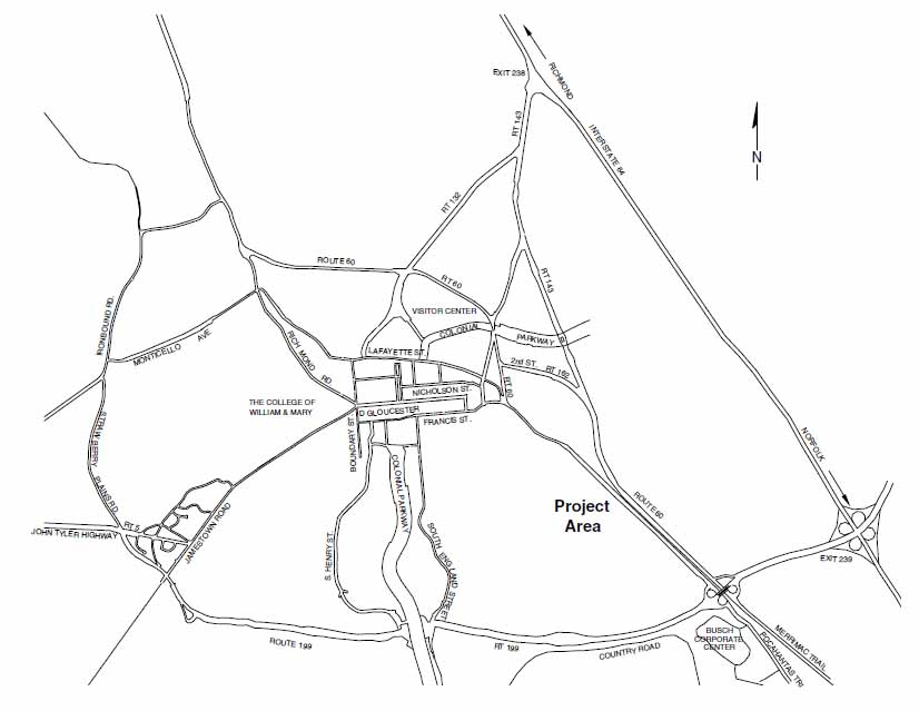 Figure 1. Location of the project area.
2
were excavated at varying collapsed intervals in order to more thoroughly explore certain features. This document details the results of the Phase II assessments, and provides recommendations for the future management of the sites.
Figure 1. Location of the project area.
2
were excavated at varying collapsed intervals in order to more thoroughly explore certain features. This document details the results of the Phase II assessments, and provides recommendations for the future management of the sites.
The Phase II assessments of 44JC1040 and 44JC1041 were conducted under the general supervision of Dr. Marley R. Brown III, Director of the Department of Archaeological Research at Colonial Williamsburg, and under the direct supervision of David Muraca, Staff Archaeologist. Project Archaeologist Mark Kostro supervised the field crew comprised of Paul Nasca, Ryan Remis, and Katie Thomason. Isabel Jenkins processed the artifacts in the lab, Heather Harvey completed the report graphics, and Mark Kostro prepared the text for this report.
Description of the Project Area
Sites 44JC1040 and 44JC1041 lie within property owned by the Colonial Williamsburg Foundation, one and one-quarter mile southeast of Colonial Williamsburg's Historic Area along Route 60. The sites overlook to the north and west a deep ravine that contains a small tributary creek leading to Tutter's Neck Pond. Within the parcel, site 44JC1040 is located on top of wooded flat terrace in the south half of the parcel. The terrain gradually slops down into ravines and gullies to the north south, east and west of the site's center, each draining into the tributary leading west to Tutter's Neck Pond. Based on the results of the Phase I shovel testing, the site area measured approximately 120 × 90 meters. The Phase II fieldwork confirmed these dimensions for the site area. Subsequently, additional Phase I survey was conducted of the property immediately south of 44JC1040. The additional survey recovered a small number of historic and prehistoric artifacts in shovel tests 15 meters south of the previously determined boundaries of 44JC1040. The artifacts were similar to those recovered from 44JC1040. Therefore, based on these additional findings, the southern extent of 44JC1040 should be extended an additional 45-meters south of its previously determined extent to include the area around these shovel tests. The newly determined site area measures 165 × 90 meters.
The second site, 44JC1041, is located directly north of 44JC1040. The site is characterized by two long, narrow, parallel flat terraces. The terraces are separated by a shallow gully that drains north into the ravine. The parallel terraces define the eastern and western limits of 44JC1041. The Phase I results determined the site area to measure 100 × 100 meters. The Phase II results expanded these dimensions to include an area that measured 140 × 100 meters.
Environmental Setting
Sites 44JC1040 and 44JC1041 are both situated within the Atlantic Coastal Plain physiographic province of southeastern Virginia. The area is generally characterized by a well-developed drainage pattern consisting of high level terraces dissected by streams and steep ravines with seasonal creeks (Hodges et al. 1985). The average winter temperature is 41 degrees Fahrenheit (5 degrees Celsius) and the average spring/summer temperature is 76 degrees Fahrenheit (25 degrees Celsius). The average relative humidity ranges from 80% or less in the morning to 60% or less in the afternoon. Prevailing winds are generally 3 strong (over 15 mph), mostly originating from the southwest (Virginia Peninsula Industrial Council 1976).
The soils found within both sites are characterized as moderately well to well drained, predominantly loamy, and are generally classified within the Slagle-Emporia-Uchee complex. Within the complex, the Slagle soils consist of a fine sandy loam to a clay loam and are found on top of the terraces and on the sides of slopes. The Emporia soils are found on the sides of slopes, and narrow ridges, and consist of fine sandy loam to a sandy clay loam. The Uchee soils are found steep slopes and rides, and consist of sandy clay loam mottled with clay. Both the Slagle and Emporia soils are well suited for farming (Hodges et al. 1985:9-11).
Both sites are currently wooded. The modern vegetative cover over both the sites consists primarily of secondary deciduous forests. Oaks and American holly trees are the most common within the forest. Understory vegetation, consisting of primarily briars and poison ivy, varies from minimal to abundant across the two sites.
The sites' vegetation and proximity to water resources provides food and shelter to a diverse number of animal species. Terrestrial animals observed inhabiting the project area includes, but is not limited to, deer, raccoons, opossums, skunks, squirrels, rabbits, and muskrats. The area is similarly inhabited by various amphibians and reptiles, including snakes, lizards, frogs, toads, and turtles. A diverse group of birds also use the area.
Previous Archaeology
In November and December 1999, Colonial Williamsburg Foundation's Department of Archaeological Research identified sites 44JC1040 and 44JC1041 in the course of a Phase I archaeological survey of a 16-acre parcel of property under consideration for development by the Colonial Williamsburg Foundation. The Phase I results suggested that 44JC1040 was a late seventeenth-century to early eighteenth-century domestic site. The site identification was based on the recovery of a concentration of artifacts that typically dated to that time period. The recovery of bricks and nails during the Phase I further suggested that a structure may have once stood at that location. As a result of these findings a Phase II archaeological assessment of 44JC1040 was recommended for the site prior to any additional alteration to the property (Kostro 2000).
The second site, 44JC1041, was identified as a multi-component site, with evidence from the Phase I survey to suggest overlapping prehistoric, seventeenth- and eighteenth-century components. Artifacts from both seventeenth and eighteenth-centuries indicated different domestic occupations at the site. Brick fragments and nails were also recovered from both components indicating that structures associated with the occupations may have once existed at the site. The prehistoric artifacts recovered indicated that the prehistoric occupation of the site dated to the Middle Woodland period (2500-1100 BP). The site's prehistoric component had been previously identified, in the late 1980's, as part of a preliminary walkover survey, and limited subsurface testing, of the Foundation's properties (Foundation Survey Field Notes n.d.). The results of the preliminary survey have not been formally reported on, although the survey maps and field notes from the survey are on file at the Department of Archaeological Research. The 1999 Phase I survey confirmed the previous Foundation Survey results (Kostro 2000). As a result of these findings, a 4 Phase II archaeological assessment of the site was recommended for 44JC1041 prior to any additional alteration to the property (Kostro 2000).
Chapter 2.
Prehistoric Overview
Native American culture, prior to European contact, can be divided into three main periods: the Paleo-Indian period, the Archaic period, and the Woodland period. The Paleo-Indian stage of cultural development lasted from 12,000-10,000 BP (years before present). The Archaic stage lasted from 10,000-3200 BP and is subdivided into three separate stages of cultural development, including Early Archaic (10,000-8500 BP), Middle Archaic (8500-5000 BP), and Late Archaic (5000-3200 BP). The Woodland period lasted from 3200-400 BP and is also subdivided into three cultural stages. The Woodland period subdivisions consist of Early Woodland (3200-2500 BP), Middle Woodland (2500-1100 BP), and Late Woodland (1100-400 BP). Each of these stages of Native American prehistory are marked by notable socio-cultural and material changes.
The Paleo-Indian Period (12,000-10,000 BP)
Debate has long raged within the academic community over the date and method of human settlement of North America. Current research indicates the earliest definitive inhabitation of the United States at around 12,000-10,000 BP. The most likely point of entry for these first inhabitants of the North American continent is from Asia via the Bering Land Bridge (Turner 1989; Brown et al. 1986).
Paleo-Indians arrived in Virginia around 10,000 BP. During this time, the Pleistocene era, the last of the ice ages, was coming to an end. The climate shifted dramatically, with warmer temperatures and decreased precipitation. The climatic shifts exposed large sections of the continental shelf upon which the Tidewater sits, which were previously, and are once again submerged under water. The forests adjusted accordingly, becoming dominated by oak and pine. Large game animals, such as mammoth and mastodon, were replaced by smaller animals including: deer, turkey, and turtle (Metz et al. 1998). This shifting climate greatly influenced the life ways of the Paleo-Indians, turning them away from big game hunting and toward the gathering of plant food and hunting of small game (Blanton et al. 2000).
Paleo-Indians manipulated their settlement patterns and tool kits to fit their environment. They lived in band level societies operating across a large, relatively fixed area (Blanton et al. 2000). They utilized small base camps and outlying hunting camps, both on a temporary basis. Generally these sites were chosen based on the availability of both rock for tool making (essentially jasper and quartz) and animals for hunting. Very few of these sites have been discovered in Virginia, the notable exceptions being the Thunderbird and Flint Run Paleo-Indian Complex sites in northwestern Virginia and the Williamson site in Dinwiddie County (Turner 1989). No substantial sites have been uncovered in the Williamsburg area, although individual points dating to the Paleo-Indian period have been located in disturbed contexts, namely plowzone (Brown et al. 1986).
The most common component of the Paleo-Indian tool kit recovered by archaeologists is the projectile point and flakes related to its manufacture. The earliest projectile tool produced by Paleo-Indians and unearthed in Virginia is the Clovis Point. It is a relatively 6 thin point, lancelet and fluted, with a concave base and lateral and sometimes basal thinning (Johnson 1989). In later Paleo-Indian sites, Dalton-Hardaway pints also became part of the Paleo-Indian artifact assemblage. The Dalton Point (one of which was uncovered during archaeological excavations at the Bruton Heights School Complex in Williamsburg) is a broad, thin blade with finely serrated edges, a slight excurvature, and a sharp point. The appearance of Dalton points suggests a shift in lithic technology from a Clovis-dominated tool kit to one that contained tools designed for specific purposes (Metz et al. 1998).
Paleo-Indian sites are rare around Williamsburg and on the Peninsula in general. No intact stratagraphic sites have been identified in the Tidewater, and most of the points recovered are from heavily plowed areas. This has to do partially with the fact that the jasper and quartz, considered as the preferred raw materials for tool making by the Paleo-Indians, are not available in significant quantities in the area. Additionally, many of the areas in the Tidewater that would have been habitable during the late Pleistocene are now submerged under water. Therefore, any analysis of Paleo-Indian culture on the Virginia Peninsula comes from the examination of the dozen or so points recovered in isolation on un-stratified sites (Blanton et al. 2000; Brown et al. 1986; Reinhart 1989).
The Archaic Period (10,000-3200 BP)
The Archaic period is marked by a shift from the late Ice Age environment of the Pleistocene to the more modern environment of the Holocene. Populations increased during this period, leaving behind a richer and more complex archaeological record than their forebears.
Early Archaic (10,000-8500 BP)
As with the Paleo-Indian period, there is an academic debate surrounding the Early Archaic period. Many scholars argue that because it shares much in common culturally with the Paleo-Indian period, the Early Archaic should be included within it (Blanton et al. 2000; Brown et al. 1986). Indeed, the climate and environment remained much the same, with similar boreal forests populated with the same game animals and food resources (Custer 1990). For the purposes of this report, however, a more traditional approach will be taken in which the years from 10,000-8500 BP are contained within the Archaic period.
The Early Archaic had much in common culturally with the Paleo-Indian period. Inhabitants of Virginia continued to organize themselves in band level societies. Settlement patterns remained much the same, with base and hunting camps extending over a large, but well-defined area. During this period some larger base camps were established along the Chickahominy and James Rivers (Brown et al. 1986).
There were changes in the basic tool kit during the Early Archaic period. Projectile points became corner notched and serrated. The earliest of these corner notched points is the Palmer point which was in use circa 10,000 BP. This was followed by the Kirk Notched, which becomes a part of the tool kit around 9300 BP. The Kirk Stemmed point is the latest of these new points, coming into existence circa 9000 BP (Custer 1990). Less common notched points from the period include Kessell, Charleston, and Amos. The 7 primary use for these points continued to be the procurement of animal food stuffs. Other tools, such as stone adzes and grinding slabs, become a part of the tool kit during the Early Archaic as well (Blanton et al. 2000).
As with the Paleo-Indian period, very few Early Archaic sites exists on the Peninsula which have been discovered and/or investigated archaeologically (Custer 1990). There are no known intact stratagraphic sites on the James-York Peninsula. Lack of data is a key factor in the continuing debate about where exactly the Early Archaic belongs in the cultural and temporal record.
Middle Archaic (8500-5000 BP)
The Middle Archaic was characterized by changing environmental conditions. Warmer, moister temperatures and greater seasonal variation led to changes in Native American settlement patterns. Native Americans continued to live in band level societies, occupying temporary camps in search of food. However, the habitats in which they settled, became more varied (Blanton et al. 2000; Custer 1990). For the first time, Native Americans were moving into the upland interiors of Virginia. There are two possible explanations for this move to the uplands. The first is related to shrinking group territories due to increased population (Blanton et al. 2000). The second is related to the spread of deciduous trees into new areas due climatic changes. This increase in deciduous trees led to an increase in the number of productive habitats that could be taken advantage of by native inhabitants. It is quite likely that these two causes worked in tandem to draw Native Virginians into the upland areas (Custer 1990).
Tool kits also changed during the Middle Archaic period. There was a move during this period away from the use of highly localized quality jasper and quartz and toward the use of local stone for tool making. It was also during this period that bifurcate forms came into use, followed by Stanly, Morrow Mountain, Guilford, and Halifax points. These stone points were of much lower quality than the tools of the Paleo-Indian and Early Archaic periods (Custer 1990). The Middle Archaic also saw an increase in the use of more informal tools geared toward the high mobility of a band level society (Blanton et al. 2000).
The Middle Archaic period has, like the Early Archaic, left little evidence behind to guide us toward an understanding of its culture. This is especially true of the Tidewater area. Coastal flooding and the rising sea level have most likely destroyed many of the sites on the James/York Peninsula. There is speculation that the lack of sites may also be related to poor survey coverage of the area (Custer 1990). The site most relevant to the Peninsula is the Slade site in southeastern Virginia, which included bifurcate points and a human burial with associate burial goods including an end and side scraper and a chipped stone adz (Geier 1990). Enough is known about the Middle Archaic to classify it as the "beginning of a continuum of cultural adaptation which concludes with the establishment of a network of highly adapted localized Hunter Gatherer communities during the Late Archaic" (Geier 1990: 84) .
Late Archaic (5000-3200 BP)
A previously mentioned, the Native Americans of the Late Archaic were characterized by a network of highly adapted, and localized hunter-gatherer communities (Geier 1990:84). They, unlike their predecessors, had the advantage of living in a fully developed Holocene environment with stabilized estuaries and sea levels. According to Dent (1995) this lead to a scheduled and seasonal procurement of food, or what is known as a collectors strategy (cited in Blanton et al. 2000).
Inhabitants of the Late Archaic period established semi-permanent base camps at stream heads on upper terraces and on the gently sloping south sides of lower terraces (Blanton et al. 2000; Mouer 1991). These camps were not permanent settlements though some were used repeatedly over the course of many seasons. Inhabitants also continued to frequent outlying camps for the purposes of hunting animals, and gathering plant foods. During this time, Native Americans became highly adapted to the deciduous forest environment of the Holocene, settling in areas where the soils are best suited to the growth of large stands of nut bearing hardwoods. Nuts were a key element of the Late Archaic diet, along with turkey and deer. Because of this, most recorded sites in Virginia are clustered around the base of the Blue Ridge Mountains (Mouer 1991).
Although not to the extent as in previous periods, there continues to be a dearth of information left behind by residents of the James-York Peninsula during the Late Archaic period. Only a relatively small number of these sites have thus far been identified on the peninsula including, Deep Bottom site on the James River, and the Keck, Reynolds Alvis, Nase, and Posnick sites on the Chickahominy River (all in Henrico County). The archetypal site from the period, however, is the Halifax Complex located in the Virginia/North Carolina Piedmont. The site is named for the diagnostic Halifax points found there. The Halifax point, along with the Lamoka, Lackawaxen, Brewerton, and others, is highly representative of the period (Mouer 1991). Other tools which find their way into the tool kit included ground stone axes, carved stone bowls, and stone drills.
Mouer (1991) argues that a large part of the Late Archaic should actually be classified as the Transitional period (roughly 4500-3200 BP), a term first coined by Witthoft in 1953. The argument for this classification is that during this Transitional period inhabitants of the Late Archaic became increasingly riverine, meaning they settled along and relied heavily upon rivers. The Transitional period is also earmarked by the appearance of soapstone bowls, and "broad spear" points (Mouer 1991). Although the Transitional period is classified within the Late Archaic, it is important to note that this riverine adaptation and change in tool technology occurred around 4500 BP. It is at this time that large shell middens first appear, evidencing Native Americans new reliance on riverine resources.
The Woodland Period (3200-400 BP)
The Woodland Period is the best understood of the three major periods of Virginia prehistory. Significant advances, both technological and cultural, occurred during this period. During the Woodland phase, population greatly increased, ceramic vessels were first produced, certain plants were domesticated, and inhabitants moved from band to tribal, and finally to chiefdom levels of social organization. It is, like the Archaic, divided into three sub-periods.
Early Woodland (3200-2500 BP)
The Early Woodland saw the expansion and intensification of the Native American's subsistence base (Hodges 1991). Although in some ways it continued to be similar to the Late Archaic, especially in the reliance on rivers and particularly fish and oysters, several significant changes did occur during the Early Woodland.
Native Americans during the Early Woodland made the move toward more sedentary living, although they continued to utilize outlying hunting camps (Blanton et al. 2000; Hodges 1991; Mouer 1991). During this period, different groups began to utilize more circumscribed territories. Mouer (1991) argues that they also instituted buffer zones, which were not settled by any particular group, but which were used by a variety of groups and separated one "territory" from another. It is also likely that during this time more extensive trade networks were developed over larger areas, with active trade occurring between groups within these newly developed buffer zones (Blanton et al. 2000; Mouer 1991).
Essential to the characterization of the Early Woodland is the introduction of ceramic bowls. This technology provides a definate material departure from the Late Archaic period. The nomenclature and technical distinctions between different ware types is quite complex and beyond the scope of this summary, but suffice it to say, that coil built, cord marked, sand and/or soapstone tempered ceramics are common finds on Early Woodland archaeological sites (Mouer 1991).
Although there are few sites across the Peninsula, their numbers increase from the Chickahominy River west. For the most part, these "sites" are likely outlying hunting camps, as evidenced by the shell middens located at the York River State Park (Blanton et al. 2000). Mouer (1991) suggests that part of the coastal plain was contained within one of the previously mentioned buffer zones, explaining why small encampments, rather than more sedentary village sites, have been located. It remains possible that the area was used extensively for trade and food procurement, but not settled, even semi-permanently, by any one group.
Middle Woodland (2500-1100 BP)
During the Middle Woodland period, the Native American populations of Virginia began organizing themselves into tribal rather than band level societies. This was by far the most significant of the transitions that occurred during this period. Many of the cultural traits we recognize as "Native American" came into existence during this middle phase of the Woodland period.
Stewart (1992) defines two basic phases of cultural and material development for the Virginia coastal area during the Middle Woodland period. Middle Woodland I is represented by Popes Creek and related ceramics and lasts from 2500 to 1800 BP. The second phase, Middle Woodland II, is represented by Mockley and Mockley-like ceramics and lasts from 1800 to 1100 BP. Generally, they are shell tempered and course, and are found throughout the Coastal Plain during the Middle Woodland.
During this period relatively extensive trade networks in ceramics and stone, for tool production, developed across Virginia. The coastal plain of Virginia is a part of a pan-Mid-Atlantic culture characterized by similar ceramic patterns commonly found on sites from Maryland to the James River. This continuity argues for a degree of cultural homogeneity, 10 perhaps caused by the use of ceramic ware distribution in order to foster inter-group cooperation. (Blanton et al. 2000; McLearen 1992; Stewart 1992). This indicates a much more highly developed trade and communication network than was seen in the Archaic or Early Woodland periods.
Subsistence patterns remained much the same as in the Early Woodland with a continued heavy reliance on local plants, small game, and fish and oysters from local rivers. However, for the first time, inhabitants of the Middle Woodland began to selectively nurture, or possibly even domesticate, local plants. (Blanton et al. 2000; Stewart 1992). The domestication of plants, although rudimentary, was essential to the development of more intensive agriculture in the Late Woodland period.
Settlement patterns varied only slightly from those of the Early Woodland. People continued to live in semi-sedentary base camps with satellite collector sites (Blanton et al. 2000). The larger base camps were located in settings where a variety of plant and animal resources were readily available. Often this meant near a salt/fresh water interface. The smaller satellite camps were then placed along streams and used for collecting during various parts of the year. Populations of each group or "tribe" were supervised by an achieved-status "Big Man" who managed their communal subsistence projects (Stewart 1992).
Middle Woodland sites are much more abundant than Early Woodland sites. This is true of much of the Peninsula. The 1992 excavations at the Locust Grove Tract at Carter's Grove Plantation revealed both a Middle Woodland hearth and a separate procurement site (Moodey 1992). The best known sites on the coastal plain are the Maycocks Point, Hatch, and Irwin sites in Prince George County, and the Diascund Creek and Aignon #3 sites in New Kent County (McLearen 1992). Although much more is known about the Middle Woodlands than previous periods, it is still relatively untouched archaeologically.
Late Woodland (1100-400 BP)
The Late Woodland is the best understood of all Virginia's pre-contact periods. It was during this period that Native Virginian's made the move toward sedentary village life, and established first a tribal level of social organization, and later in the period, a chiefdom.
According to Turner (1992), the Late Woodland is best characterized as a period of rapid change. The period saw "an increase in the importance of agriculture and local lifeways accompanied by increased population, larger sedentary villages, and increasingly complex means of social integration" (Turner 1992: 97) . Throughout much of the period, native populations lived in tribal organizations, with groups of 1000 or less residing most of the year in sedentary villages. It wasn't until near the end of the period, around 1600, that chiefdoms began to emerge (Blanton et al. 2000). The Algonquian Powhatan represent the culmination of the changes, which occurred on the coastal plain during the Late Woodland, becoming the dominant chiefdom on the Virginia coastal plain (Turner 1992).
Economically, the inhabitants of the Late Woodland established a sophisticated collector system based on hunter-gatherer technology, augmented by agriculture, and a highly refined understanding of local resources and their availability. Native Americans planted beans, pumpkins, squash, and maize using a form of agriculture known as "swidden" in which fields are cleared from the forest and used on a rotating basis (Blanton et al. 2000; Turner 1992). With the rise of chiefdoms, a more sophisticated society, and increased 11 population, cultivated plants (along with deer skins, mussel shells, etc.) were not only important for their nutritional value, but also as statements of wealth. By the end of the Woodland period, smoked oysters were being used as trade/tribute (Barfield and Barber 1992).
Shell tempered wares dominated the Late Woodland period. There was quite a bit of ceramic variability throughout the Tidewater, although shell tempered Chickahominy ware was known generally throughout the area. Chickahominy was accompanied by another shell-tempered ceramic, Townsend-ware, which was often fabric impressed or incised. However, by the end of the Late Woodland, a plain type Townsend-ware is found to the exclusion of other wares in the Tidewater; and specifically at the core of what was the Powhatan Chiefdom, namely the confluence of the Pamunkey and Mattaponi, and along the York River and portions of the lower Rappahannock (Turner 1992).
By the end of the Late Woodland, the Tidewater area was dominated by the Powhatan chiefdom. The James and Upper York drainages became the domain of the Powhatan and included six smaller chiefdoms. When necessary, the Powhatan used force to subsume what amounted to thirty-two native groups into their chiefdom, although it is believed that their hold over these groups was probably tenuous (Blanton et al. 2000). A system of tribute was instated, with the chief of the Powhatan living and receiving tribute in a sedentary village such as Werowocommoco on the York River (Barfield and Barber 1992).
The Virginia coastal plain during the Late Woodland, according to Turner (1992), is better represented archaeologically than most of eastern North America. Site 44JC398, located on the Chickahominy River, represents a Powhatan village occupied prior to and just after European contact (Blanton et al. 2000). White Oak Point (44WM119) contains a well preserved shell midden and faunal dumping ground. The Addingon site (44VB9) represents a spring and summer fishery (Barfield and Barber 1992). Although there remains a relative lack of stratified sites which have been excavated and interpreted, the remains of stratagraphically disturbed campsites have been located throughout James City and York Counties. However, the Late Woodland and Proto-historic eras continue to take a back seat to Historic sites in the Tidewater area. (Brown et al. 1986).
12Chapter 3.
Historical Overview and Analysis
Documentary research into sites 44JC1040 and 44JC1041 has provided precious little specific information about the historical ownership and development of the property on which the sites are located. The greatest obstacle to historical research has been the destruction of the James City County records during the Civil War. Almost no county documents exist for the period before the war. Consequently, the historical background for sites within James City County, from the early seventeenth century to the mid-nineteenth century, is highly fragmented, and largely drawn from secondary sources.
In 1607, the Virginia Company founded the first permanent English settlement at Jamestown. After establishing the settlement at Jamestown, additional settlements were founded primarily along the major navigable waterways. During this early period of the colony, Jamestown remained as the center of the colony's urban activity (Higgins and Gray 1997:9).
In the first quarter of the seventeenth century, the cultivation of tobacco grew to become the economic base of the early colony. In 1618, to encourage tobacco cultivation and further settlement, the Virginia Company ratified the "Great Charter," outlining the headright system of land ownership for the colony. Under the headright system, individuals who paid their transportation, or the transportation of another person to Virginia, would receive 50 acres of land in the new colony for each new immigrant (McCartney 1997:39). The headright system, and the desire for more land for tobacco cultivation, were important factors stimulating the expansion of the colony's settlement from the Eastern Shore to the fall line of the James River (Kelso 1984:9).
Among the earliest areas settled, by the Virginia Company, outside of Jamestown was the area known as Archer's Hope. Archer's Hope was situated along the north shore of the James River, between Mill Creek and Wareham's Pond (Grove Creek). Mill Creek divided Archer's Hope from Glebe Land and Neck of Land to the west, and Wareham's Pond (Grove Creek) separated Archer's Hope from Martin's Hundred to the east. By 1625, between fourteen and sixteen individuals, were living at Archer's Hope, and four or five houses had been built there (Fessler 2000:15, Goodwin 1958:5-6). Beginning in 1629, and continuing throughout the rest of the seventeenth century, as more people moved into area, the area of Archer's Hope became further subdivided. The area between Glebe Land and the west side of Archer's Hope Creek (College Creek) continued to be known as Archer's Hope, however, east of Archer's Hope Creek (College Creek) extending to Martin's Hundred, the area was divided into smaller tracts known variously as: Hampton Key, Mounts Bay, Harrop, Littletown, Utopia, Tuttey's Neck, Barren Neck, Farley's Neck, and Kingsmill Neck, among others (Fessler 2000:15). Beginning the eighteenth century and continuing until present-day, the area east of Archer's Hope Creek (College Creek) came to be known under the collective name of Kingsmill.
As settlements grew along the rivers, the desire for more land for tobacco cultivation also fueled the Colony's expansion into the interior of the peninsula. However, early attempts by the English to expand into the interior were often met with resistance by the local 14 Powhatan Indians who claimed the peninsula as their own territory. Conflict with the Powhatan grew increasingly hostile during the early period of expansion by the English colonists. In 1622, attempting to check the flow of European expansion, the Powhatan Indians lead a revolt against the English settlements along the James River. A total of 347 colonists, over a third of the colony's population, was killed as a result of the uprising. After the uprising, many of the colony's outlying settlements were temporarily abandoned, and the colonists retreated to Jamestown. The retreat, however, was short lived, and by late 1623 many of the colonists had returned to their former settlements (McCartney 1997:49-52).
Although temporarily slowed by the uprising in 1622, colonial expansion continued to move inland, and continued to be fueled by the promise of more land for pasture and agriculture (Metz et al. 1998:15). In 1632/3, an Act of Assembly formally established Middle Plantation as the first interior community on the peninsula, and fifty-acre land grants were offered to those individuals who were willing to settle at Middle Plantation. In 1634, it was further decided to erect a palisade between the heads of Archers Hope Creek (College Creek) and Queens Creek, through Middle Plantation to provide protection for the colonists from attacks by Native Americans (Metz et al. 1998:22).
The land grant incentives, and the construction of the palisade in 1634, successfully stimulated the settlement of the inland community at Middle Plantation. Land patent research, for the Middle Plantation period, suggests that the palisade was the key landmark defining the extent of Middle Plantation. Within the patent descriptions, the palisade is frequently listed as a property line reference (Haley 1995:7; Levy 2000:5). A recent study of the land patents suggests that the extent of Middle Plantation's area was initially limited to the lands immediately adjacent to the palisade. By mid-century, however, the limits of Middle Plantation's extent appear to have expanded to include areas near the palisade, but not necessarily immediately adjacent to it (Haley 1995:7). Significantly, the remnants of a portion of the original 1634 palisade were located during archaeological excavations at Bruton Heights in 1994.
As suggested above, the identification of the palisade's location is integral to the understanding of the distribution of land patents within Middle Plantation. Sites 44JC1040 and 44JC1041 are situated approximately two miles southeast of the known portion of the 1634 palisade at Bruton Heights. The distance of the sites to the palisade suggests that the area of the sites was not likely settled as part of the initial settlement of Middle Plantation in 1634. The property is also situated approximately four miles inland from the James River, making the area most likely too far inland to have been settled as part of one of the early Kingsmill patents along the James River between Archer's Hope Creek (College Creek) and Martin's Hundred. Considering the sites' locations in relation to the 1634 palisade, and the James River, the settlement of the lands encompassing the sites did not likely occur before the middle of the seventeenth century (Figure 2).
Recent historical and archaeological research has greatly enhanced our knowledge of both Middle Plantation (see Haley 1995; Metz et al. 1998; Levy 2000) and the Kingsmill area plantations during the seventeenth century (see Kelso 1984; Fesler 2000; Mallios 2000; Underwood 2000). During this time, Middle Plantation was emerging from a loosely organized community into an important civic center. Meanwhile, Kingsmill grew from a series of independent land patents into two large consolidated plantations. Unfortunately,
15
 Figure 2. Extent of settlement by 1650.
however, very little is known about the area lying between Middle Plantation and Kingsmill, including the area that encompasses site's 44JC1040 and 44JC1041.
Figure 2. Extent of settlement by 1650.
however, very little is known about the area lying between Middle Plantation and Kingsmill, including the area that encompasses site's 44JC1040 and 44JC1041.
Surviving seventeenth-century land patents have offered vague clues to the ownership of the lands between Middle Plantation and Kingsmill, specifically the property encompassing 44JC1040 and 44JC1041. In 1632, Dr. John Pott obtained the patent for a large inland 1200-acre tract near the head of Archers Hope Creek (College Creek). However, the area measurements contained within the early patents are consistently inaccurate, and are at best, only crude estimates of the patented areas (Bruce 1896:534-552, in Fesler 2000:19). Nevertheless, the large size of Pott's patent potentially situates sites 44JC1040 and 44JC1041 within the vicinity of Pott's patent. Although, Pott's original patent has not survived, Potts ownership of the land can be traced through later patent descriptions of the property.
16John Pott was a physician and former deputy Governor of the colony. He was also among the first individuals to patent land within Middle Plantation (Metz et al. 1998:22). When construction of the palisade through Middle Plantation began, one out of every forty men between Archer's Hope Creek (College Creek) and Queens Creek was ordered to report to Pott's house "newly built" at Middle Plantation on March 1, 1633/34 to assist in the palisade's construction (Metz et al. 1998:22). Pott's "newly built" house was presumably built within the 1,200-acre patent at the head of Archer's Hope Creek (College Creek). Other individuals, presumably indentured servants transported to Virginia by Pott, or other tenants leasing portions of Pott's land, may have also lived on the tract. These unknown individuals probably also built additional houses or structures at various locations within Pott's extensive patent.
Upon Dr. John Pott's death, some of his land patents were apparently inherited by his brother Captain Francis Pott including, the 1,200-acre patent. Around 1639, Francis Pott sold the 1,200-acre tract to William Davis (Davies). Davis' patent for the tract was recorded on June 28, 1639. Davis' patent is significant because it describes the extent of the 1,200-acres originally patented by John Pott.
WILLIAM DAVIS, 1,200 acs. James City Co., June 28, 1639, page 661. N. upon land of Lt. Richard Popely, S. upon Capt. Humphry Higginson, W. upon head of Archers Hope Cr. E. toward bryery Swamp. Due for trans. of 24 pers: Sara Browne, Isaac _____, Andre Howell, Ann Keeding, Nicho. Goldsmith, Wm. Burfer, Thomas Thorrogood, John Barker, Morgan Williams, Wm. Davis, Richard Shaw, John Badden, Abigail Drewry, Richard Vardall, Mathew Burrow, Tho. Floyd, John Pierce, Richard Prichard, Joan, a Negro (Nugent 1979:I:112).The property description, however, is given in relation to other patents, or in relation to geographical landmarks whose names been long forgotten or changed over time. As a result, present-day reconstructions of where the patents were situated within the landscape are somewhat speculative.
Among the neighboring patent holders, Lt. Richard Popely (Popeley) is identified as owning land north of the 1,200-acre Pott/Davis tract. Popely's property included a 1,250-acre tract patented on June 10, 1639. The Popeley tract was situated, "At the Midle Plantation upon the Pallisadoes, …upon the head of Queens Cr." (Nugent 1979:I:113) .
To the south of the Pott/Davis 1,200-acre patent, Capt. Humphrey Higginson is listed as a neighbor. Higginson's property, at that time, included a 700-acre tract of land known as Tuttey's Neck.1 The area of Tuttey's Neck consisted of the land extending northeast from the confluence of today's Tutter's Neck Creek and Halfway Creek. Higginson's patent describes the properties boundaries as, "E.S.E. upon a gr. Swamp parting it from Harrop land, W.S.W. upon a br. of Archers hope Cr. parting it from land of Richard Brewsters called by the name of the great neck alias the barren neck & N.N.W. into the main woods" (Nugent 1963:I:80) . The patent further suggests that Higginson had acquired the land via his wife Elizabeth (Nugent 1979:I:80). Elizabeth was the widow of Dr. John Pott, and apparently received the property upon the death of her first husband (Fesler 2000:17).
17The eastern edge of Davis' patent is somewhat ambiguous. The east end of the patent is not defined as being directly upon or against a particular landmark or against another individual's patent. Instead, the east end is vaguely described as, "E. toward bryery swamp," a hereto unknown swamp. The deliberately vague language of the patent may indicate that the eastern extent of the patent had not been clearly demarcated at the time of the patent issue.
In 1644, William Davis (Davies) re-patented the 1200-acre tract that he had purchased from Francis Pott in 1639. The 1644 patent is significant because it identifies the 1200-acre tract as formerly being the property of Capt. Francis Pott, who inherited the property from his brother, Dr. John Pott. The patent also provides more information about neighboring patents, and lists additional landmarks to more clearly situate the boundaries of the patent within the landscape:
WILLIAM DAVIES, 1,200 acs. James City Co., 27 Mar. 1644, p.367. Lying near the head of Archers Hope Cr., neare the horse path, W. & down a swamp parallel to Tuttyes neck, unto marked trees dividing this from the land of Mr. Richard Brewster, unto a branch near the head of Ware Cr. This tract runneth E. upon Deer bone Vally. Due by purchase of Capt. Francis Pott., brother & heire of Dr. John Pott, and due sd. Dr Pott by act of court dated 6 ____ 1632 & confirmed to sd. Capt. (Francis Pott) ‒ by act of court, 13 June 1642. Incomplete(Nugent 1979:I:225).
The 1644 Davis patent lists Richard Brewster's property as abutting the 1,200-acres, separated by "marked trees." Richard Brewster's land in 1644, consisted of a 500-acre tract known as "the great neck alias the barren neck" (Nugent 1963:I:142) . Known to most as Barren Neck, Brewster's patent was situated south upon today's Halfway Creek, between the main branch of Archer's Hope Creek (College Creek) and Tutter's Neck Creek. Archer's Hope Creek (College Creek) separated Brewster's land from Jockey's Neck to the west, Halfway Creek separated it from Kingsmill to the south, and Tutter's Neck Creek separated the land from Tuttey's Neck to the east.2 Similar to Davis, Brewster purchased the property at Barren Neck from Capt. Francis Pott, who had also inherited the property from his brother Dr. John Pott.3
The 1644 patent describes the eastern border of the patent as running, "E. upon Deer bone Vally." As a named topographic feature, "Deer bone Vally" must have been an obvious landscape feature. Unfortunately, the place name did not survive, nor does it appear on any known maps of the area. Furthermore, "Deer bone Vally" is only mentioned in two patents for the area, both patents regarding the same tract. The second 18 mention of "Deer bone Vally" is not until 1656. In that year, John Bromfield aquired the Pott/Davis 1,200-acre patent by marrying the widow of William Davis. Bromfield's patent similarly lists the 1,200-acre tract as bounding upon "Deer bone Vally" (Nugent 1963:I:336). Based comparisons between the patent descriptions and on modern topographic maps, a possible candidate for "Deer bone Vally" may be the deep ravine running from northeast to southwest, beginning near today's Chesapeake and Ohio Railroad Tracks and terminating on the northeastern end of today's Tutter's Neck Pond. Within the ravine bottom, a small creek runs south and feeds into Tutter's Neck Pond.
"Ware creek" is also mentioned as a reference point within the patent. Unfortunately, like "Deer bone Vally," its historical location has also been lost over time. Once again, by comparing the patent descriptions with modern topographic maps, a possible match has been identified between the seventeenth-century "Ware creek" and a possible twenty-first century corollary. At the southeastern end of Tutter's Neck Pond, a moderate-sized creek (Tutter's Neck Creek) flows southward, and eventually drains into Halfway Creek. Although based on only limited descriptions, this creek appears to match the location described in Davis' 1644 patent, and may be the twenty-first century corollary to the "Ware creek." Both "Deer bone Vally" and "Ware Creek" are part of the same drainage system ultimately feeding into Halfway Creek. "Deer bone Vally" seems to refer to the upper portion of the drainage, north of Tutter's Neck Pond, which contains a small tributary creek; "Ware Creek" appears to refer to the lower portion of the drainage containing the moderate sized creek, Tutter's Neck Creek, which flows from the southern end of Tutter's Neck Pond and into Halfway Creek.
If the above analysis is correct, and the eastern border of the Pott/Davis/Bromfield patent described as, "Deer bone Vally" is the same as the ravine extending northeast from Tutter's Neck Pond, sites 44JC1040 and 44JC1041 appear to be outside the Pott/Davis/Bromfield patents. Both sites are located on terraces on the east bank of the ravine, and thus east of the land originally patented by Pott and later by Davis and Bromfield. In other words, the sites appear to be located on the opposite side of the ravine that delineates the eastern boundary of the 1,200-acre Pott/Davis/Bromfield patent.
Considering the information found within the patents for Pott, Davis and Bromfield, four different possible theories have been developed regarding the ownership of the property east of the ravine (i.e., "Deer bone Vally"). The first, second, and third possibilities each assume that the above hypothesis on the eastern boundary of the Pott/Davis/Bromfield (i.e., "Deer bone Vally") is correct. The fourth possibility assumes that the above hypothesis is incorrect.
Theory #1: The land east of the Pott/Davis/Bromfield patent (east of "Deer bone Vally,") was un-patented at the time of the Pott (1632), Davis (1639 and 1644), and Bromfield (1656) patent issues. This theory is consistent with the known settlement pattern for the area during the first half of the seventeenth century. As previously stated, the early settlement was concentrated along the coastline. Inland settlement did not begin until the establishment of Middle Plantation in 1633/4, and those patents were clustered adjacent to, or nearby, the palisade between Archer's Hope Creek (College Creek) and Queen's Creek.
19Theory #2: The land was occupied by an individual unknown to twenty-first century researchers. The land may not have been formally patented, as individuals in the seventeenth century sometimes did not patent their land in order to avoid paying the Crown's annual quitrent fees (Fesler 2000:20).
Theory #3: The land was part of Humphrey Higginson's 700-acre Tuttey's Neck patent. Higginson's original patent is ambiguous about the northern extent of his patent stating simply, "N.N.W. into the maine woods" (Nugent 1979:I:80). The location of the boundary between the "maine woods" and Higginson's Tuttey's Neck patent is not known. If this scenario is accurate, the land east of "Deer bone Vally" may have been part of Higginson's Harrop plantation which lay to the south and east.
Theory #4: Unlike the previous theories, Theory #4 supposes that "Deer bone Vally" is not the ravine discussed above. Alternatively, "Deer bone Vally" is actually situated further to the east; thus the sites would be included within the Pott/Davis/Bromfield patent. Geography, however, suggests that this theory is highly unlikely. The next closest ravine to the east is modern-day Whiteman Swamp, which drains into King's Creek. Even considering the inaccuracies of seventeenth-century patent measurements, Whiteman's Swamp is well beyond the extent of a 1,200-acre patent situated along the 1634 palisade.
Of the above, proposed possibilities, Theories #1 and #3 have the highest likelihood of being correct. Theory #1 is corroborated by known settlement patterns for the area. On the other hand, Theory #3 is also potentially correct because of the large size (700 acres) and ambiguous description of Higginson's patent, thus potentially situating the sites within Higginson's land. Unfortunately, due to the paucity of colonial records from area, the real answer to the question of who owned the land in the seventeenth century may never be conclusively answered.
Further land patent research, of those dated to the second half the seventeenth century, similarly failed to any discover definitive information about land ownership for the property containing sites 44JC1040 and 44JC1041. However, for the Tuttey's Neck tract, in 1665 Christopher Higginson, the brother and heir of Humphrey Higginson, inherited the property (William & Mary Quarterly 4(1st s.):186). Christorpher Higginson died in 1673, but his will has not survived. What happened to the Higgginson family tract at Tuttey's Neck after 1673 is unclear.
In the last quarter of the seventeenth century, four additional individuals can be traced to the Tuttey's Neck tract, and may have included the property containing 44JC1040 and 44JC1041. In 1679, Edward Gray sold a parcel of land at "Tuttis Neck" to William Smith of Gloucester County (Noël Hume 1966:36). Unfortunately, no mention is made as to the size, boundaries or the neighboring properties. Nor does there exist any mention of how or when Gray acquired the property. Three years later, in 1682, Otho Thorpe bequeathed, in his will, to his cousin John Grice a plantation called "Tuttis Neck" (Noël Hume 1966:36). Once again, however, no property description, or how Thorpe acquired "Tuttis Neck" is included. Are the Gray/Smith tract and Thorpe/Grice tract at "Tuttis Neck" the same tracts, or are they adjacent tracts within Tuttey's Neck? Furthermore, it is also unknown how these tracts are related to Humphrey Higginson's 700-acre Tuttey's Neck tract patented in 1637. The incomplete documentary record is also unclear if the Gray/Smith 20 land or the Thorpe/Grice land are located within the boundaries of the land originally patented by Higginson, or are the tracts abutting Higginson's original patent?
At the turn of the eighteenth century, the plantations along the James River between Archer's Hope Creek (College Creek) and Martin's Hundred were consolidated into two large plantations. Colonel Thomas Pettus combined the Littletown and Utopia tracts, as well as an additional 280-acre tract to the north, into a single 1,280-acre plantation, which was sold by his heirs to James Bray II in 1700 (Fessler 2000:21). Similarly, at an unknown date prior to 1710, Lewis Burwell II had acquired Harrop and Kingsmill Neck (Goodwin 1958:12). Both the Bray and the Burwell families would continue to control the area known today as Kingsmill for the most of the eighteenth century.
Meanwhile, during the final quarter of the seventeenth century, Jamestown's role as the center of colony had diminished significantly, and the community at Middle Plantation had grown in both size and political strength (Metz et al. 1998:85). The construction of Bruton Church, and the establishment of the College of William & Mary at Middle Plantation, signified the ever-increasing importance of the former inland outpost. Middle Plantation ultimately eclipsed Jamestown as the colony's center in 1699 when the capital was relocated from Jamestown to Middle Plantation, and the surrounding community was renamed Williamsburg (McCartney 1997:135-138).
The ownership of the property encompassing 44JC1040 and 44JC1041, in the eighteenth century, is equally as unclear as it is for the seventeenth century. Once again, the surviving documents with property descriptions fail to provide enough detail in order to conclusively ascribe the property to a particular individual, or to identify the property as being part of particular tract of land. The documentary record, however, does provide a number of clues as to the ownership of neighboring properties.
On the west side of the deep ravine (believed to be known as "Deer bone Vally" in the seventeenth century) over which sites 44JC1040 and 44JC1041 overlook, Angelica Bray patented 190-acres along the ravine in 1698. The property had been escheated from the estate of John Fisher (Nugent 1979:III:18), who had acquired the patent at an unknown date. Angelica Bray was the wife of James Bray I, who owned 290 acres of land at Middle Plantation (most likely abutting Angelica's property).4 Upon Angelica Bray's death, her 190-acre patent along the west bank of the ravine was inherited by her son David Bray I (Stephenson 1963:2-4).
At the time of Angelica Bray's purchase, the identity of who owned the land on the east side of the ravine ("Deer bone Vally") has escaped the historical record. However, as previously discussed, the western boundary of Tuttey's (Tutter's, Tutties) Neck may have included the ravine ("Deer bone Vally"), dividing it from Angelica Bray's land. At this point, Tuttey's Neck may have included or at least abutted the property containing sites 44JC1040 and 44JC1041. Unfortunately, after John Grice's acquisition of a patent in Tuttey's Neck in 1682, a nearly thirty-year gap exists in the ownership of Tuttey's Neck. The next mention of Tuttey's Neck is not until 1711. In that year, Frederick Jones patented 100-acres of land at "Lutties Neck,"5 escheated from Matthew Brown. The patents suggests 21 that prior to 1711, Matthew Brown apparently owned 100-acres at "Lutties Neck," but the documentarly record once again fails to identify when, and from whom, Matthew Brown acquired the property (Noël Hume 1966:36). The archaeological remains of Frederick Jones' house at Tuttey's Neck were located during salvage archaeological excavations by Ivor Noël Hume in 1960-61 (Noël Hume 1966; Kelso 1984:109-112).
Around 1717, Judith Bray, widow of David Bray I, acquired 300-acres at Tuttey's Neck from Frederick Jones. Upon Judith Bray's death in 1720, her son David Bray II inherited his mother's 300 acres at Tuttey's Neck, and the 190-acres his father had previously inherited from Angelica Bray. Previously (in 1700), David Bray II had also inherited his uncle's property at Middle Plantation (now Williamsburg) which had been part of the 290 acres originally purchased by James Bray I (Stephenson 1963:9).6 Upon his death in 1732, David Bray II owned a large number of properties in and around Williamsburg, including 300 acres at Tuttey's Neck, 290 acres formerly in Middle Plantation, and 190 acres originally patented by Angelica Bray. When he died, the Tuttey's Neck property was willed to John Randolph. In that same year, Randolph deeded the Tuttey's Neck property to Thomas Bray II in exchange for other Bray family holdings in York County (Stephenson 1963:22; Underwood 1999:24).
In 1744, Thomas Bray II, already the owner of Tuttey's Neck, also inherited the plantation operations at Littletown and Utopia from his son James Bray III, who had without any children of his own.7 According to entries into James Bray III's ledger (1736-1744), at least two plantation managers were employed by the Bray family, including John Green and Benjamin Tureman. In the early 1740's, Tureman is believed to have worked the land at Tuttey's Neck. As payment, Tureman received shares of tobacco, in addition to corn, wheat, pears, wood, and cider brandy, all reportedly produced at Tuttey's Neck (Kelso 1984:38-39; McClure 1977:43-44).
Upon his death in 1751, Thomas Bray II owned significant portions of the land southeast of Williamsburg, including Littletown, Tuttey's Neck, and the Bray family lands in Williamsburg, later known as Bassett Hall. In 1751, after Thomas Bray II's death, Tuttey's Neck, the Bassett Hall property and Littletown, were all inherited by Thomas Bray II's daughter, Elizabeth Bray Johnson. Elizabeth Bray Johnson died in 1765, at which point, the three properties (Littletown, Tuttey's Neck and Bassett Hall), were all inherited by her husband Col. Philip Johnson. Beginning in 1758, some of the properties inherited by Elizabeth Bray Johnson, were held in trust by various trustees for the benefit of Elizabeth and Philip's children (Stephenson 1963:18).
22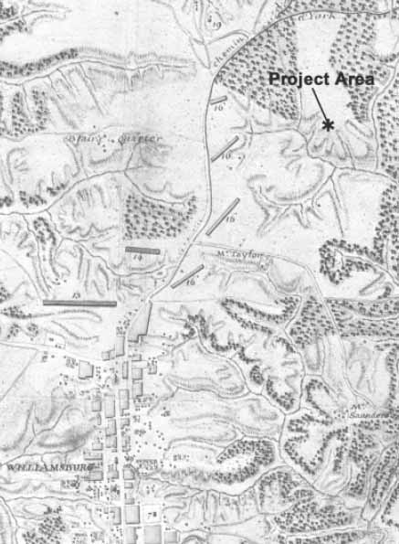 Figure 3. Desandrouins, "Map of the Environs of Williamsburg, in Virginia."
The Bray lands in Williamsburg and Tuttey's Neck were advertised for sale in the Virginia Gazette in October and November 1771. In the property descriptions included in the sale notices, Tuttey's Neck was described as "…containing about six Hundred Acres, more or less, very convenient to the City of Williamsburg, whereon are all necessary Houses for Cropping" (Stephenson 1959:8-9) . The Bray property in Williamsburg was apparently not sold, and was advertised for sale again in 1773 (Stephenson 1959:10). However, Tuttey's Neck is not included as among the properties listed for sale. It is possible that the Bray family property at Tuttey's Neck may have already been sold prior to 1773 possibly as a result of the 1771 advertisement. There exists no further mention of Tuttey's Neck in the documentary record after 1771.
In 1782, a map of the Williamsburg area was drawn by French engineer Jean Nicholas Desandrouins (Figure 3). On the map, the land on which 44JC1040 and 44JC1041 are located is clearly distinguishable, and is depicted as a part of a large cleared field extending between the ravine leading to Tutter's Neck Pond and "Chemin d'York" or 23 present-day Penniman Road and Route 60. The map does not indicate any structures within the vicinity of the sites. However, approximately one mile to the southwest of the sites, "Southall's Quarter" is shown as a cluster of buildings along Quarterpath Road. It is likely that the name "Quarterpath" originally referred to the path leading to a quarter, denoting a section of a plantation that was often separate from the land surrounding a planter's dwelling, and typically the site of dwellings for slaves or tenants (Gibbs 1988:3).8 According to James City County Land Tax records, John Southall payed taxes on 920 acres that he owned in James City County in 1783 (JCCLTR:M-I-57). This is undoubtedly the same Southall as depicted on the 1781 Desandrouins map. Unfortunately, no tax records exist for prior to 1783, thus it remains unknown when Southall acquired the property. But from Desandrouins map, we know it was at least as early as 1781. Additionally, John Southall was also listed as a farm manager for Henry Martin at Kingsmill in 1785, according to James City County personal property tax records for that year (Underwood 1999:27).9
In 1803, William Allen purchased the 920 acres from Southall's estate. Allen combined the Southall tract with his other, previous James City County properties, including Littletown (in 1796) and Kingsmill (in 1801). The combination of these properties, along with a small 12-acre tract from Samual Tyler in 1810, formed a continuous 3,712-acre tract known collectively as Kingsmill Farm. Allen likely never lived at Kingsmill, but rather employed overseers to run the plantation operations there (Goodwin 1958:58). William Allen died in 1831, and the Kingsmill property was inherited by William Griffin Orgain. As as condition of the inheritance, William Griffin Orgain's name was changed to William Allen (Goodwin 1958:61).
The combined 3,712-acre Kingsmill tract apparently remained unbroken until 1851. Tax records indicate that after 1851, William Allen's Kingsmill consisted of 2,792-acres. The 2,792 acres evidently included the tracts formerly noted as 1,280 acres (Littletown), 1,500 acres (Kingsmill), and 12 acres (formerly S. Tyler's). After 1857, an additional 404.5 acres in York County were also included as part of Kingsmill (Goodwin 1958:lxv). Absent from Allen's holdings after 1851 was the 920-acre Southall tract. The tax data suggests that William Allen had sold off, or disposed of otherwise, the 920-acre tract from the Kingsmill property in that year. Unfortunately, however, no further evidence of what became of the 920-acre tract exists. The remaining portions of Kingsmill continued to be owned by members of the Allen family until 1876 (Goodwin 1958:64).
In the early years of the Civil War (1861-1865), the area across the peninsula between Williamsburg and Yorktown was the site of a series of Confederate military fortifications designed to defend the area against the Union army during the Peninsula Campaign. In 1862, Major General "Prince" John Bankhead Magruder, commander of the Confederate Army of the Peninsula, built a series of defensive lines across the peninsula
24
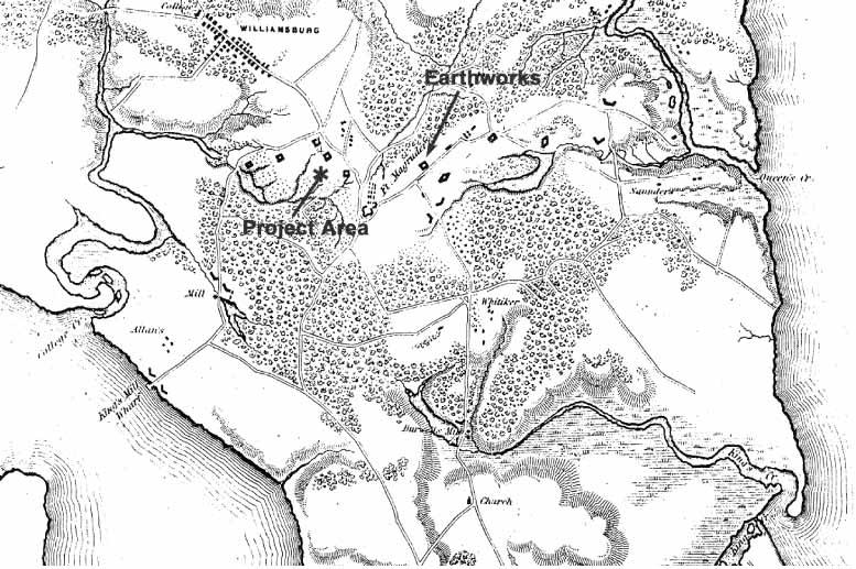 Figure 4. A.A. Humphreys (1862), "Yorktown to Williamsburg."
designed to hold back the advance of the Union army from Fort Monroe in Hampton, to the Confederate capital at Richmond. As part of the extensive defensive network, Magruder constructed a line of earthworks between Tutter's Neck Pond and Cub Creek (Figure 4).
Figure 4. A.A. Humphreys (1862), "Yorktown to Williamsburg."
designed to hold back the advance of the Union army from Fort Monroe in Hampton, to the Confederate capital at Richmond. As part of the extensive defensive network, Magruder constructed a line of earthworks between Tutter's Neck Pond and Cub Creek (Figure 4).
The line of earthworks came to be known as the "Williamsburg Line" or "Magruder Line" and consisted of thirteen flanking earthwork redoubts and a large bastioned fort, Fort Magruder, located in the center. The forts were purposefully laid out to take advantage of the natural obstacle posed by the terrain. In particular, Redoubts #1 through #4 were built behind the deep ravine that stretched northeast from Tutter's Neck Pond. Sites 44JC1040 and 44JC1041 are both located on the east bank of the same ravine. The deep ravine allowed the Confederate troops to move between the redoubts, shielded from the enemy's sight and fire. In addition to using the natural terrain, a wide band was cleared of trees in front of the forts to eliminate any protection for the approaching Union army. Within the cleared band were small rifle pits scattered across the area. To further slow the Union advance, a large belt of felled trees, or abates, was piled beyond the cleared band (Hastings and Hastings 1997:39-47).
On May 5, 1862, the "Williamsburg Line" became the site of a day-long engagement, known as the "Battle of Williamsburg," between the Union and Confederate forces. The early morning fighting concentrated along the Confederate right flank around the low-numbered redoubts. By the afternoon, Union and Confederate forces were engaged all across the Williamsburg Line. The fighting continued back and forth across the line with little advancement by either side. Once darkness set in, and the fighting ceased the Confederate army abandoned its defenses and retreated to Richmond. The Battle of Williamsburg was over (Hastings and Hastings 1997:117).
25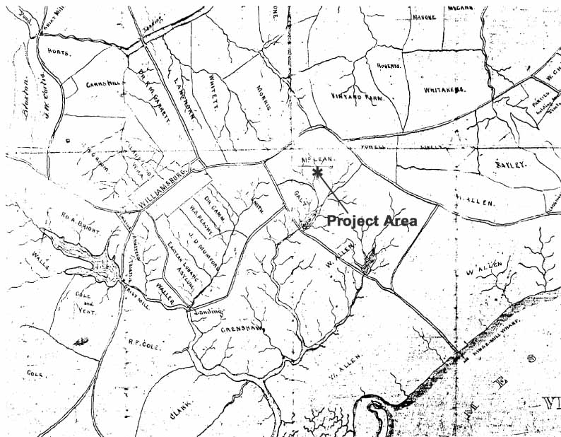 Figure 5. "Vicinity of Yorktown and Williamsburg, Virginia 1871."
A few years after the conclusion of the Civil War, a map of the area entitled "Vicinity of Yorktown and Williamsburg, Virginia, 1871" was produced (Figure 5). The map illustrates the boundaries between the properties in the area, as well as identifying the names of the property owners. According to the map, sites 44JC1040 and 44JC1041 are both located within a property owned by "McLean," northwest of the Allen family's Kingsmill Farm. The "McLean" property is bounded on the southeast by the land of William Allen, on the northeast and northwest by present-day Penniman Road, to the southwest by Quarterpath Road, property held by "Galt," and Tutter's Neck Pond. Whether or not the land now owned by McLean was once part of the 920-acre Southall tract is not positively known, although the close proximity to both William Allen's remaining Kingsmill Farm in 1871, and former site of "Southall's Quarter," shown on Desandruoins 1781 map, does strongly hint at that prospect.
In 1881, the Chesapeake and Ohio Railroad laid its tracts through Williamsburg, and through the center of what had been McLean's land (McCartney 1997:361). Presumably, with the installation of the railroad through the property, the land was most likely no longer used for farming. By 1914 portion of the former McLean property containing sites 44JC1040 and 44JC1041 was owned by John and Julia Wickre. The 1914 U.S.G.S map (Figure 6) indicates that a dirt path or road cut though the property between Penniman Road and Quarterpath Road, although no structures are shown in the area.
26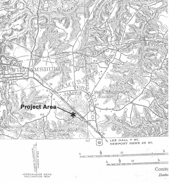 Figure 6. 1914 U.S.G.S. map of Williamsburg.
During the first half of the twentieth century, the Wickre's property fronting along Route 60 was the planned location of the "Colonial Terrace" residential subdivision. The brick and cinder-block foundation ruins of several of the homes presumably built as part of the Colonial Terrace subdivision were observed during the 1999 Phase I survey of the property (Kostro 1999:29).
In 1941, a 58.29-acre portion of the former McLean property, containing sites 44JC1040 and 44JC1041, was inherited by John and Julia Wickre's children and their children's spouses (JCC WB 4:454). The Wickre children held the property until 1953, at which point it was sold to Samuel M. and Dagmar A. Brafford (JCC DB 50:424). Two years later, the Braffords sold the property to John D. Rockefeller (JCC DB 56:76). Finally, in February 1960, John D. Rockefeller conveyed the property, along with several other adjacent properties, to Colonial Williamsburg, Incorporated (JCC DB 73:447).
Chapter 4.
Research Design and Methods
Research Design
The results of the 1999 Phase I survey served as the basis for developing the research design for the Phase II assessments of sites 44JC1040 and 44JC1041. As discussed in Chapter 1, the research design for the Phase II assessment was devised in order to delineate the boundaries of the identified sites, to better define their respective periods of occupation, and to determine the integrity and significance of each of the sites' preserved remains. Based on these determinations, each site would be further evaluated in terms of each site's eligibility for nomination to the National Register of Historic Places. Eligibility for the National Register of Historic Places is determined if one or more of the following criteria can be applied to it:
- A.The site is associated with events that have made a significant contribution to the broad patterns of American history; or
- B.The site is associated with the lives of persons significant in our past; or
- C.The site embodies the distinctive characters of a type, period, or method of construction, or that it represents the work of a master, or that it possess high artistic values, or represents a significant and distinguishable entity whose components may lack individual distinction; or
- D.The site has yielded or may be likely to yield, information important in prehistory or history.
Finally, recommendations for the future management of each site are put forth with particular attention to each site's significance, eligibility to the National Register, and the nature of the impact to each site. Management recommendations are generally grouped into one of three possibilities: (1) site avoidance, (2) mitigation or Phase III data recovery, or (3) no further archaeological work is necessary. The specific cultural resource management recommendations regarding 44JC1040 and 44JC1041 are listed in Chapter 7 of this report.
Field Methods
The field methods employed in the Phase II assessment of 44JC1040 and 44JC1041 were designed in order to fulfill the goals and answer the questions of the project research design set forth above. A Cartesian grid was imposed over both sites in order to provide horizontal control over the recovered information. Because of the close physical proximity of the two sites, a single continuous grid was imposed over both sites. The grid's north-south axis was orientated at 60 degrees west of magnetic north. A base point was arbitrarily assigned the grid coordinates 1000 north/1000 east. All units were assigned coordinates with respect to base point. All test unit grid coordinates were measured from the northwest corner of each unit. In general, tests were regularly spaced at 10-meter intervals along the grid. When time constraints permitted, additional test were excavated at varying collapsed intervals to more thoroughly explore certain features.
28A total of one hundred five 75-cm-square test units were excavated through shovel stripping and hand troweling from across the two sites. Each test unit was stratigraphically excavated to maintain vertical control over the recovered information. Stratagraphic layers were determined through differences in soil color and texture. Detailed descriptions of the stratigraphy were recorded for each test unit including: thickness, soil type, and soil color. Features exposed within the test units were also recorded, but not excavated—with one exception. Each feature was mapped, photographed, and described in detail. Every unit was dug to undisturbed subsoil, and all excavated soils were passed through ¼-inch mesh screen. All artifacts recovered during the excavations were retained for laboratory analysis.
Laboratory Methods
All artifacts recovered during the excavations were sent to the D.A.R. Laboratory for processing and analysis. Artifacts were washed, labeled, identified and inventoried according to provenience. All artifact inventory information was entered into the D.A.R.'s archaeological database computer program, Re:discovery. Artifacts were inventoried using a standard descriptive typology with all obvious functional and morphological characteristics noted. Based on the artifactual information, each context was assigned a terminus post quem (T.P.Q.), based on the artifact with the most recent date of manufacture. The T.P.Q. represents the date after which the context was deposited. Additionally, various artifact distributions and patterns were plotted in the form of contour maps using Surferâ a statistical mapping program. All of the field documentation, artifacts, and artifact information recovered during the fieldwork, and subsequent laboratory analysis, are stored at the Department of Archaeological Research's laboratory.
Chapter 5.
44JC1040
Results and Interpretations
A multi-component site, 44JC1040 contains evidence of both colonial and Native American occupations. The site is located on top of a raised flat terrace that extends north and west, and overlooks a ravine with a creek that flows west towards Tutter's Neck Pond (Figure 7). The ravine and creek are located approximately 200 meters from the site, and represents the closest source of water for the site. The vegetative cover across the site is primarily secondary deciduous forest consisting primarily of oak and holly trees. Only a minimal amount of understory vegetation, consisting of mostly of a small number of different varieties of brier plants, covers the ground surface at
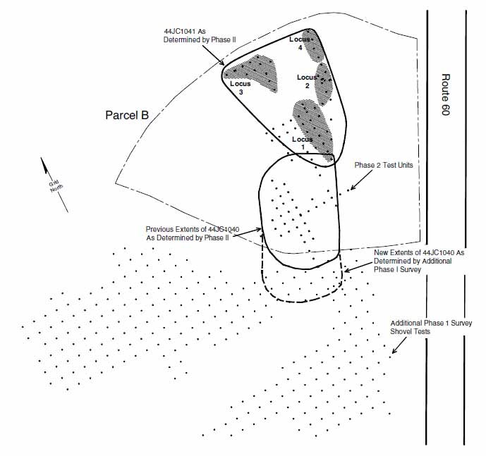 Figure 7. Site map of 44JC1040.
30
Figure 7. Site map of 44JC1040.
30
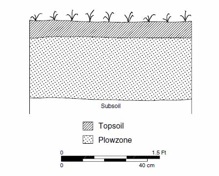 Figure 8. Typical soil profile for 44JC1040.
the site. The soil profile (Figure 8) consisted of a silt loam topsoil (Munsell color 10YR3/2), over a sandy loam plowzone (10YR5/4), over a sandy clay subsoil (10YR6/8). The recorded soil profile is the effect of the site having been previously plowed. The majority of the artifacts recovered (both historic and prehistoric) were typically collected from the plowzone layers. The only additional obvious disturbance was a pair of wheel ruts from a former dirt path or logging road through the site. Soil survey maps indicate that the soils within the site area are generally well suited for farming (Hodges 1985:9-11).
Figure 8. Typical soil profile for 44JC1040.
the site. The soil profile (Figure 8) consisted of a silt loam topsoil (Munsell color 10YR3/2), over a sandy loam plowzone (10YR5/4), over a sandy clay subsoil (10YR6/8). The recorded soil profile is the effect of the site having been previously plowed. The majority of the artifacts recovered (both historic and prehistoric) were typically collected from the plowzone layers. The only additional obvious disturbance was a pair of wheel ruts from a former dirt path or logging road through the site. Soil survey maps indicate that the soils within the site area are generally well suited for farming (Hodges 1985:9-11).
The previous Phase I investigation identified 44JC1040 as a domestic site, occupied from the late seventeenth to the early eighteenth century. The determination of the site boundaries was based on a concentration of seventeenth- and eighteenth-century artifacts covering an area of approximately 120 × 90 meters. Artifacts recovered from the Phase I shovel testing included tobacco pipe stems, English delftware, Westerwald stoneware, Fulham stoneware, Red Sandy coarse earthenware, locally produced coarse earthenware, Border ware, Iberian coarse earthenware, wine bottle glass, brick and nails. The recovery of brick and nails during the Phase I further indicated that a structure may have once stood at the site. As a result, of the Phase I findings, a Phase II archaeological assessment of 44JC1040 was recommended in order to more clearly delineate the boundaries of the site, to better define the age of the site's occupation, and to determine the integrity and significance of the site's preserved remains (Kostro 2000).
The Phase II archaeological assessment of 44JC1040 began on July 25, 2000, and consisted of the excavation of a total of forty-four 75-cm-square test units. The assessment confirmed the previous identification of a late seventeenth- through early eighteenth-century occupation at the site. A previously undetected Middle to Late Archaic (8,500-3,200 BP) Native American component was also identified at the site. The results of the Phase II assessment, with regard to both the colonial and Native American components of the site, are discussed individually in the following paragraphs.
In addition, subsequent to the completion of the Phase II fieldwork at 44JC1040, a Phase I archaeological survey was completed of the adjacent property (Parcel C), located directly south of 44JC1040. A summary of the results of the Phase I survey of Parcel C included as Appendix A of this report. In the course of the Phase I survey, 31 additional colonial and Native American artifacts were recovered from three shovel tests adjacent to 44JC1040. These artifacts are believed to be associated with the various occupations of 44JC1040. As a result of this additional information, the boundaries of 44JC1040 were extended 45 meters south of the site's previously determined extent to include the area around these three shovel tests (see Figure 7).
Colonial Occupation
Evidence of 44JC1040's colonial occupation was established through the recovery of a large quantity of historic artifacts (n=1058), many of which were datable to the seventeenth and eighteenth-centuries, and the discovery of fourteen intact subsurface features. The combination of feature identifications and the subsequent artifact analysis, has provided a significant amount of information about the site's colonial occupants.
Feature Descriptions
A total of fourteen sub-surface features were discovered at 44JC1040 (Table 1). For ease in identification, the features were numbered one through fourteen. Eleven of the fourteen features are potentially the result of human occupation of the site. Although their identifications are tentative (thus subject to change), the variety of features discovered at
| Feature # | Unit Coordinates | Context #'s | Feature Description |
|---|---|---|---|
| 1 | 1010N/1000E | 51AC-5-6 | Circular root disturbance |
| 2 | 1010N/1000E | 51AC-7-8 | Linear root disturbance |
| 3 | 1020N/1000E | 51AC-15-16 | Rectangular-shaped feature—possible posthole |
| 4 | 1031N/999E | 51AC-27-28 | Ditch |
| 5 | 1010N/1010E | 51AC-45-46 | Dark organic stain, undetermined function |
| 6 | 1010N/1010E | 51AC-48-49, | Root cellar |
| 1010.75N/1010E | 51AC-81-82 | ||
| 7 | 1010N/1010E | 51AC-50-51 | Oval-shaped feature—possible posthole |
| 8 | 1010N/1040E | 51AC-59-60 | Circular root disturbance |
| 9 | 1000N/990E | 51AC-65-66 | Square-shaped feature—possible posthole |
| 10 | 1020N/1010E | 51AC-87-88 | Circular-shaped feature—possible posthole |
| 11 | 1020N/1010E | 51AC-89-90 | Plowscar |
| 12 | 1030N/1010E | 51AC-97-98 | Circular-shaped feature—possible posthole |
| 13 | 1000N/1010E | 51AC-99-100 | Plowscar |
| 14 | 1000N/980E | 51AC-119-120 | Circular-shaped feature—possible posthole |
As summarized above, most of the eleven subsurface features resulting from human occupation can be grouped into four different categories: plowscars, postholes, a ditch, and a root cellar. Plowscars are long, shallow, and narrow linear soil disturbances cut into the subsoil, formed as a result plowing a field for the planting of crops. At 44JC1040, plowscars (Features 11 and 13) were identified in two test units (1020N/1010E and 1000N/1010E), corroborating the fact that the site had once been an agricultural field.
Rounded or rectangular shaped soil stains representing possible postholes were the most common type of feature encountered at 44JC1040. The postholes may have supported the horizontal support ports of a post-in-the-ground structure, a common type of architecture throughout the Chesapeake in the seventeenth and eighteenth centuries (Carson et. al. 1981). Alternatively, the postholes may have held in place a post for a fence line. A total of six possible posthole features (Features 3, 7, 9, 10, 12, and 14) were identified at the site. The posthole features were all clustered on the east half of the site, on top of the uppermost part of the terrace. The fill from within the posthole features was relatively consistent, containing a brown (10YR4/3) silt loam with varying amounts of brick and charcoal inclusions. Additionally, a single nail was observed lodged in the fill of context Feature 12. The lone exception was Feature 7, whose fill consisted of a mottled orange and gray clay, and contained no inclusions. A considerable amount of variation was observed in the size and shape of these features at the site. The width of the posthole features ranged between 20 and 50 cm across, and the postholes shapes included squares, rectangles, circles and ovals. Because none of the features were of the same size or shape, the features are probably unrelated to one another. In other words, the features were likely from different structures or fence lines, or they were excavated at different times. Some of the postholes may have been original, while others may have been additions or repairs to existing structures or fences.
Along the northern edge of the site area, a linear ditch (Feature 4), of an undermined length, was orientated east-west along the site grid, and passed through the south half of test unit 1031N/999E (Figure 9). The feature continues both east and west, beyond the bounds of the test unit. The width (north-south) of the ditch features that ranges between 45 to 50 cm within the test unit. The fill from Feature 4 is a dark brown (10YR3/2) silt loam with brick and charcoal inclusions. Significantly, large quantity of both domestic and architectural related artifacts was recovered from the layer of plowzone laying directly above the feature.
At the southern end of the site, a root cellar or pit (Feature 6) was partially exposed within two adjoining 75-cm-square test units (1010N/1010E and 1010.75N/1010E) (Figure 10). The distinctive feature resembles similar features found at colonial domestic sites both in the local area and elsewhere in the Tidewater. The feature is orientated 20 degrees east of grid north (40 degrees west of magnetic north), and appears to be rectangular in shape, with rounded corners. Three sides of the feature were partially exposed in the test units, including the southeast corner of the feature. The southern end of the feature cuts an older posthole feature (Feature 7), also within the same test unit. The extent of the feature
33
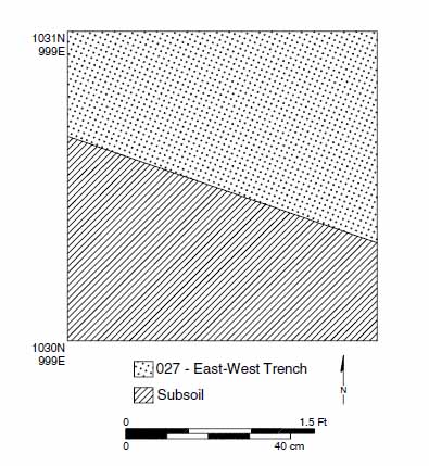 Figure 9. Plan View of Test Unit 1031N/999E with east-west trench (Feature 4).
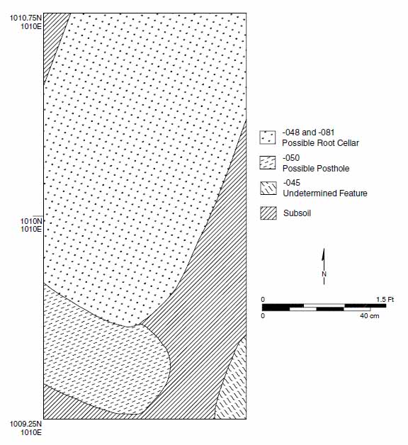 Figure 10. Plan View of Test Unit 1010N/1010E and 1010.75N/1010E with possible root cellar (Feature 6).
34
extends beyond the limits of the two test units, extending to the north, northeast, and southwest. Based on the partial exposure of the east and west sides of the feature, the feature's width measured approximately 75 cm. The exposed length of the feature, within the two test units, measured 120 cm, but the total length of the feature is unknown due to the fact that the northern extent of the feature was not exposed. The feature fill consisted of a dark brown (10YR3/2) silt loam fill. Although the fill was not excavated, a fragment of English delftware was observed lodged within the feature fill. A narrow-bore soil probe of the feature indicated that the feature extended to a depth of 30 cm below the surface of the subsoil. No evidence of any soil changes within the feature fill was observed in the soil probe.
Figure 10. Plan View of Test Unit 1010N/1010E and 1010.75N/1010E with possible root cellar (Feature 6).
34
extends beyond the limits of the two test units, extending to the north, northeast, and southwest. Based on the partial exposure of the east and west sides of the feature, the feature's width measured approximately 75 cm. The exposed length of the feature, within the two test units, measured 120 cm, but the total length of the feature is unknown due to the fact that the northern extent of the feature was not exposed. The feature fill consisted of a dark brown (10YR3/2) silt loam fill. Although the fill was not excavated, a fragment of English delftware was observed lodged within the feature fill. A narrow-bore soil probe of the feature indicated that the feature extended to a depth of 30 cm below the surface of the subsoil. No evidence of any soil changes within the feature fill was observed in the soil probe.
Finally, in the southeast corner of same test unit (1010N/1010E) that contained Features 6 and 7 (see Figure 10), a small portion of a feature of an undetermined classification was minimally exposed. The feature extends to the south and east out of the unit, and contained a dark brown (10YR2/2) silt loam fill. Unfortunately, too little of the feature was exposed in order to make a reliable determination of what the feature may represent.
Artifacts
Briefly summarized, the historic artifact assemblage from 44JC1040 consists of a wide variety of both domestic and architectural materials. The domestic assemblage includes both household items (i.e., kitchen related items), as well as personal items (i.e., clothing buttons). More specifically, the domestic assemblage at 44JC1040 includes ceramic sherds, bottle and table glass fragments, tobacco pipe stems and bowls, tools, ammunition, clothing related items, and bone fragments, among others. The architectural materials include primarily window glass and nails. Brick was also recovered in substantial quantities, but is not included within the total artifact assemblage because it was quantified by weight, rather than by the number of fragments.
A total of 201 ceramic sherds were recovered as part of the artifact assemblage from 44JC1040 (Table 2). All of the ceramics recovered from the site were typical of the late seventeenth and early eighteenth centuries. Equally important, no ceramics with a production date begining after 1730 were recovered (i.e., Jackfield, Whieldon, molded white salt-glazed, etc.). The majority of the ceramics recovered from the site were coarse earthenwares (n=94), including both domestically manufactured, and imported European wares. The locally produced coarse earthenware consisted of Colono ware, Challis, and Yorktown-type ceramics. Additional miscellaneous locally produced ceramics were also part of the assemblage, but they could not be attributed to a particular potter. European manufactured coarsewares included Red Sandy ware, North Devon gravel-tempered, Border ware, White Sandy ware, and Staffordshire Mottled ware. In addition, several other pottery fragments of European origin were recovered, but they could not be more specifically identified. Tin-enameled English delftware (n=66) represented the next most frequently recovered ceramic type. Stonewares (n=40) were the third most frequently recovered ceramic type and included Westerwald, Burslem, Nottingham, Fulham, white salt-glazed, unidentified German stoneware, unidentified English stoneware, and a single fragment of locally produced Yorktown stoneware. Finally, a single sherd of porcelain (n=1) was the only other type of ceramic recovered. In general, all the ceramics recovered from 44JC1040 are associated with food preparation and/or consumption.
35| WARE TYPE | QUANTITY | WARE TYPE | QUANTITY | |
|---|---|---|---|---|
| Coarse Earthenwares | Stonewares | |||
| Local Wares | Westerwald | 10 | ||
| Colono ware | 7 | Other | 13 | |
| Yorktown-type | 28 | Burslem | 1 | |
| Challis | 3 | Nottingham | 4 | |
| Fulham | 3 | |||
| Imported Wares | White salt-glazed | |||
| North Devon Gravel | 3 | Plain | 4 | |
| Red Sandy | 24 | Dipped | 15 | |
| Border ware | 1 | Other German | 1 | |
| White Sandy ware | 1 | Other English | 1 | |
| Staffordshire Mottled | 1 | Yorktown | 1 | |
| Other | 13 | |||
| Porcelain | ||||
| Tin-Enameled Wares | Chinese | 1 | ||
| English delftware | 66 | |||
| TOTAL | 201 |
Among glass artifacts at 44JC1040, dark green wine bottle glass fragments (n=155) were the most commonly recovered. Case bottle (n=2) and other forms of container glass (n=14) were also recovered, but in substantially lesser quantities. Table glass (n=2) was similarly recovered, but once again, only a minimal number of fragments. The wine bottle glass, case bottle glass and table glass are all related to food preparation, and consumption. The remaining small quantity of container glass fragments may have also been related to food preparation or consumption, or these vessels may have been for storage of medicines.
A small assemblage (n=81) of both locally manufactured and imported tobacco pipe fragments was recovered from 44JC1040. The locally manufactured tobacco pipe fragments (n=4) constituted only a small portion of the total tobacco pipe assemblage. Also known as Chesapeake pipes, these locally manufactured pipes were very common in the seventeenth century, but occur only infrequently in the eighteenth century. Imported tobacco pipe fragments (n=77) constituted the remainder of the assemblage of tobacco pipe fragments. A detailed analysis of using these imported tobacco pipe fragments is discussed in the following paragraphs on "Site Dating."
Other miscellaneous domestic artifacts include the fragments of a pewter spoon, a table knife blade, the blade of a draw knife, a bale seal, a glass trade bead, a button, a small copper alloy buckle, a door or furniture key, and a lead alloy musket ball. Although they represent only a very small portion of the total artifact assemblage from the site, each of these artifacts are important clues to the function of the site, and the identity of the site's former occupants. Among the most telling objects, the spoon and knife fragments are obviously related to food preparation and possibly food consumption at the site. A draw knife was also recovered at the site, a common woodworking tool that was typically part of a carpenter's or sometimes cooper's tool kit. The recovery of the draw knife blade 36 bsuggests that such activities may have been occurring at the site, or that the site may have been the home of such a tradesperson. A small white colored glass trade bead was among the most interesting artifacts recovered at the site. The bead was most likely Dutch in origin, while its production is dated to the seventeenth century. The button and buckle are both clothing articles, and the key is either for a door or piece of furniture.
Architectural artifacts from the site were generally grouped into three different categories of artifacts: nails, window glass, and brick. The recovery of each of these artifact types strongly suggests that a structure may have once stood on the location. Nails and nail fragments (n=495) were by far the largest artifact grouping. All the nails recovered at the site were either wrought or forged nails. Window glass fragments (n=30) were only minimally represented on the site. On the other hand, brick fragments were relatively abundant. Bricks fragments were weighed, rather than counted, and measured 2532 g (5.58 lb) for the entire site.
Artifact Distribution
To assess the extent of the site, and the intensity of its occupation, a contour map (Figure 11), plotting the combined distribution of all historic artifacts recovered at 44JC1040 was produced. By plotting the distribution of the artifacts, three distinct concentrations of artifacts were revealed. The largest artifact concentration (A), is focused around test unit 1031N/999E, and overlays the linear ditch feature (Feature 4) within the same unit. The large concentration covers an area of approximately 600 square meters. The second concentration (B) is focused around test unit 1010N/1010E, and overlays the root cellar feature (Feature 6) located within that same unit. The area of the second concentration is much smaller than the previous concentration, measuring only 100 square meters. Both of these artifact concentrations are located on the uppermost part of the terrace that overlooks the ravine. The third artifact concentration (C) is located 30 meters to the east of the first two concentrations, and focused around test unit 1010N/1040E. The concentration covers an area of approximately 400 square meters, but unlike the other two concentrations, it is not associated with any subsurface features.
Each of the concentrations (A, B, and C) illustrated in Figure 11 represents an area of potential activity within the site. In order to better understand the specific nature of these concentrations, the distributions of different artifact classes were plotted separately. In particular, the distributions of ceramic fragments and wine bottle fragments were plotted separately to identify potential household activity areas. Similarly, nails and brick were both individually plotted in anticipation of identifying potential locations of former structures at the site.
The distribution of ceramic fragments (Figure 12) matches closely to the distribution pattern of all artifacts across the site. Ceramic fragments are relatively evenly distributed between the three artifact concentrations (A, B, and C), and compose a significant portion of the total artifacts at each of the distinct artifact concentrations shown in Figure 12. As previously mentioned, the ceramic artifacts recovered from 44JC1040 are all primarily associated with domestic activities such as food preparation and consumption. Accordingly, each individual cluster depicted in Figure 12 represents an area where such activities are likely to have taken place.
37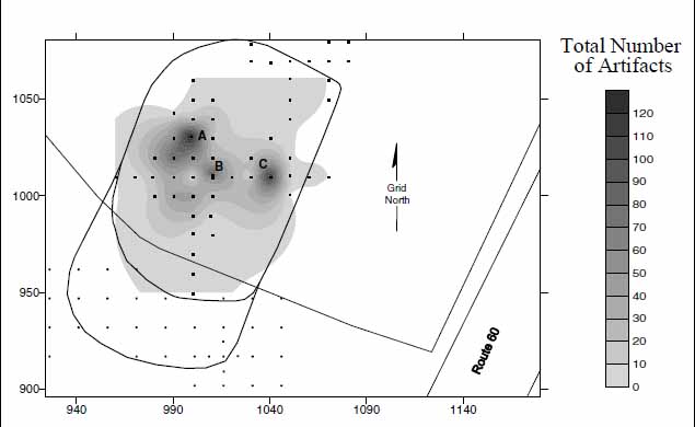 Figure 11. Distribution of all artifacts across 44JC1040.
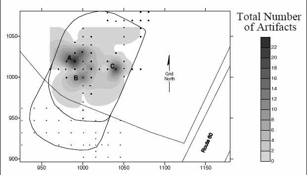 Figure 12. Distribution of ceramic artifacts across 44JC1040.
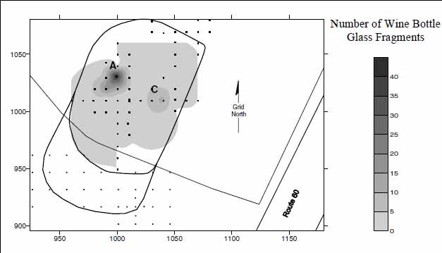 Figure 13. Distribution of wine bottle glass fragments across 44JC1040.
Wine bottle glass fragments, however, follows a different dispersal pattern (Figure 13). The vast majority of wine bottle glass fragments from the site were recovered at the north end of the site, centering around test unit 1031N/999E (Area A). A total of 99 fragments of wine bottle glass were recovered from Area A, representing 64% (99/155) of all wine bottle glass fragments recovered from the total site area of 44JC1040. A second, much smaller concentration of wine bottle glass fragments was recovered near the east end of the site at test unit 1010N/1040E (Area C). The two concentrations of wine bottle glass coincide with two of the three concentrations of ceramic artifacts. Similar to ceramic fragments, wine bottle glass fragments are usually associated with food preparation or consumption. The recovery of both wine bottle glass and ceramics at the same locations is a strong indicator that these were the locations of domestic activity at 44JC1040.
The distribution of nails (Figure 14) revealed three distinct concentrations, following an almost identical pattern of disbursement across the site area as the pattern for all artifacts from the site. An additional minor nail concentration was identified centering around test unit 1000N/990E. Significantly, a possible posthole (Feature 9) was observed cutting into the subsoil within the same unit.
The distribution of brick fragments was plotted (Figure 15), but produced slightly different results. Heavy concentrations of brick fragments were located at the northern end of the site, along the top of the terrace within neighboring test units 1020N/990E, 1020N/1010E, and 1031N/999E. Each of these test units is located within the area of main artifact concentration (Area A) illustrated in Figure 15. Additionally, a small concentration of brick is also centered on test unit 1010N/1050E (Area C), near the previously illustrated concentration of nails at 1010N/1040E at the east end of the site. Corresponding with the brick distribution was the small quantity of window glass. The majority of the window glass fragments (83%) were recovered from test units within Area A. Only a single window glass fragment was recovered from Area C and none from Area B.
By plotting and comparing the distribution of ceramics, wine bottle glass, nails, window glass, and bricks at 44JC1040, it is possible to speculate on possible locations of structures, the types of structures that may have stood on the site, and the activities associated with the structures. On top of the terrace, heavy concentrations of nail, window glass and brick were recovered around test unit 1031N/999E at the north end of the site. A heavy concentration of domestic artifacts, and the location of a ditch (Feature 4) were similarly identified at the same location. A nail concentration was also located on top of the terrace, at test unit 1010N/1010E, only 22.36 meters to the southeast. A heavy concentration of domestic artifacts were also recovered from the plowzone within 1010N/1010E, while a possible root cellar feature (Feature 6) was located cutting into subsoil within the bottom of the same test unit. Root cellar features are typically located within the interior of domestic structures, and thus the feature identification is strong evidence for a dwelling at the location.
The close proximity of the artifact clusters, and features, strongly suggests that a structure, possibly two, was located in the close vicinity of the concentrations on top of the terrace. The recovery of both nail and brick suggests that the structure was likely of wood frame construction erected either as a post-in-ground structure set directly on the ground, or it may have been set on a brick foundation. A brick hearth or chimney may have also been associated with the structure. Furthermore, artifacts relating to food preparation and
39
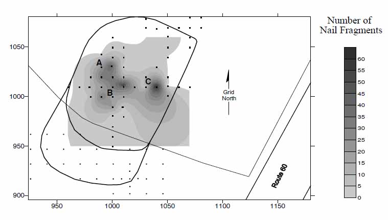 Figure 14. Distribution of nails and nail fragments across 44JC1040.
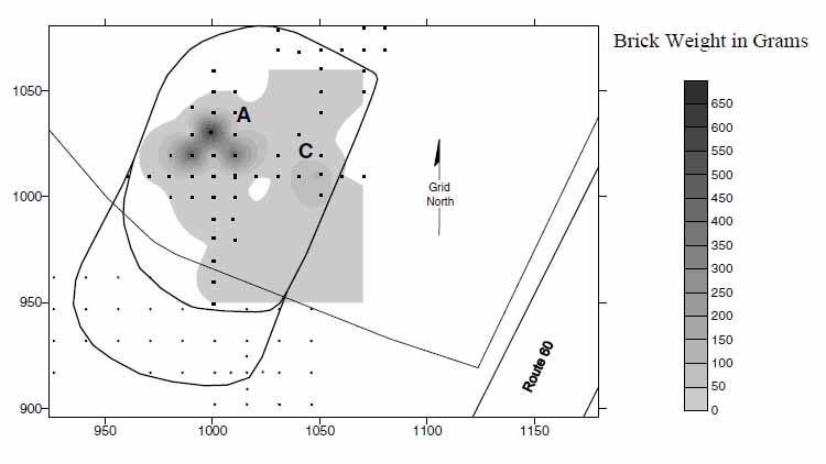 Figure 15. Distribution of brick fragments across 44JC1040.
consumption were prominent at the location, suggesting the possibility that the structure was an area where food preparation was taking place.
Figure 15. Distribution of brick fragments across 44JC1040.
consumption were prominent at the location, suggesting the possibility that the structure was an area where food preparation was taking place.
An additional possible structure may have also been located in the area between test units 1010N/1030E and 1010N/1040E. As part of the heavy concentration of artifacts, a large number of nails was recovered from the plowzone of the test unit at 1010N/1030E. Furthermore, a small concentration of brick was recovered from a neighboring test unit, 10 meters to the east. Although both nails and brick fragments did form distinct concentrations, to suggest a possible structure at the location, no subsurface features were identified to further corroborate the evidence. It is possible that sub-surface structural features may yet exist within the area, but were not encountered within any of the test units.
Site Dating
A determination of the age and duration of occupation of 44JC1040 was established by means of several different complimentary techniques frequently used by historical archaeologists in the Chesapeake and elsewhere. Each of the techniques discussed below is far from flawless, and each technique is subject to various limitations. However, by comparing the independent results of the varying methods, and taking into account each of their limitations, it is possible to formulate a reasonably secure estimatimation of a site's age and duration of occupation.
The determination of a TPQ is among the most widely used dating techniques employed by archaeologists. The TPQ date represents the date after which a particular context was deposited. The TPQ is based upon the beginning date of manufacture of the most recent artifact within a particular context. At 44JC1040, locally produced Yorktown ceramics (TPQ=1725) have the latest TPQ date for any of the artifacts recovered. The Yorktown ceramics also constitute the second largest number of ceramic fragments represented in the assemblage, after English delftware. The conclusion is that 1725 represents the earliest date that the site could have been abandoned.
Stanley South's (1977) technique of determining a mean ceramic date was also used as a method of establishing the age of the site. The mean ceramic dates for the various ceramic types were derived using date ranges published in South (1977) and Pittman (n.d.). The mean ceramic date for the site is based on 171 of the 201 ceramic fragments recovered (84.6%). It was not possible to use the total ceramic assemblage because some of the ceramic identifications were not specific enough to assign a reliable date range (i.e., "Other Local Coarse Earthenwares"). The result of the exercise was a calculated mean ceramic date of 1703 for site 44JC1040.
Following the techniques pioneered by J.C. Harrington (1954) and Lewis Binford (1962), the imported tobacco pipe stems with measurable stem bore diameters were employed as an additional method of determining possible occupation dates for 44JC1040. Forty-four fragments of imported tobacco pipe stems, out of a total of 77, were pipe stems with measurable bore diameters. The bore diameter of each of the 44 imported pipe stems was measured using a set of graduated drill bits and ranged in size from 6/64ths to 4/64ths of an inch. Pipe stems with bore's measuring 5/64ths of an inch were the most commonly sized pipe stems recovered from the site, followed by 4/64ths and 6/64ths. Figure 16 graphically illustrates the distribution of the different sizes of pipe stem bores from site 44JC1040.
In general, both Harrington's and Binford's techniques are based on the premise that through time, pipe stem bore diameters decrease in size. Harrington developed a histogram chart assembling different sized imported pipe stem bore diameters into temporal groupings. Using Harrington's method, the distribution of measurable pipe stem bore's at 44JC1040 matches most closely to the Harrington histogram period of 1710-1750. Alternatively, Lewis Binford developed a straight-line regression formula using the measured diameters of imported pipe stems to determine a mean date for a site's period of occupation. By applying Binford's formula to the pipe stem sample from 44JC1040, the calculated mean date of the site is 1753.59.
Significantly, each of the three dating methods produced a slightly different age for the site. South's method of computing a mean ceramic date suggests an early mean date of
41
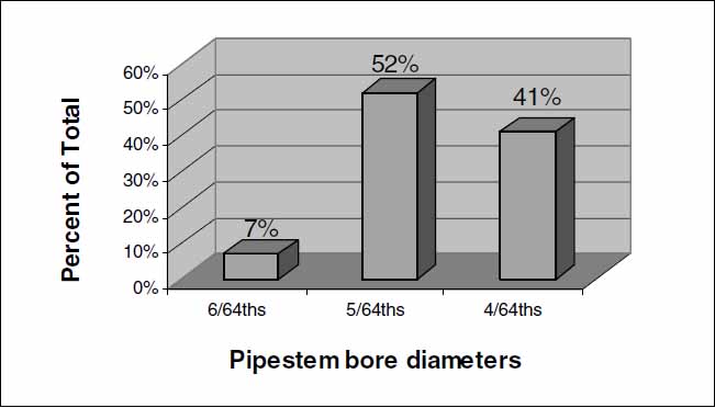 Figure 16. Tobacco pipe stem bore diameters from 44JC1040.
1703, while Binford's method suggests a later mean date of 1753/4. Situated almost perfectly between the dates determined by South's and Binford's techniques, the Harrington histogram technique suggests a date range of 1710 to 1750 for the site's occupation. Although critics have questioned the accuracy of each of these techniques (Deetz 1987; Noël Hume 1969:298-302), they are nonetheless useful for estimating the antiquity of a site's occupation. By further considering the TPQ-date of 1725 with the above mentioned mean ceramic date and tobacco pipe stem dates, it is certain that the site was occupied into the second quarter of the eighteenth century, but is not likely to have extended beyond mid-century. Establishing when the occupation of the site first began is less certain. The Harrington pipe stem dates suggest 1710, South's mean ceramic date suggests a date prior to 1703. Both techniques suggest that occupation of the site began close to the beginning of the seventeenth century. However, the recovery of several ceramic types whose production is known to have begun in the late seventeenth century (i.e., Fulham stoneware [1675], Challis coarse earthenware [1680], etc.) indicates the possibility that occupation of the site may have began as early as the fourth-quarter of the seventeenth century.
Figure 16. Tobacco pipe stem bore diameters from 44JC1040.
1703, while Binford's method suggests a later mean date of 1753/4. Situated almost perfectly between the dates determined by South's and Binford's techniques, the Harrington histogram technique suggests a date range of 1710 to 1750 for the site's occupation. Although critics have questioned the accuracy of each of these techniques (Deetz 1987; Noël Hume 1969:298-302), they are nonetheless useful for estimating the antiquity of a site's occupation. By further considering the TPQ-date of 1725 with the above mentioned mean ceramic date and tobacco pipe stem dates, it is certain that the site was occupied into the second quarter of the eighteenth century, but is not likely to have extended beyond mid-century. Establishing when the occupation of the site first began is less certain. The Harrington pipe stem dates suggest 1710, South's mean ceramic date suggests a date prior to 1703. Both techniques suggest that occupation of the site began close to the beginning of the seventeenth century. However, the recovery of several ceramic types whose production is known to have begun in the late seventeenth century (i.e., Fulham stoneware [1675], Challis coarse earthenware [1680], etc.) indicates the possibility that occupation of the site may have began as early as the fourth-quarter of the seventeenth century.
Historical Context
Based on the fragmentary history of the area, several individuals are known to have owned property in the area between ca. 1690 and ca. 1740. The list potentially begins with John Grice, who inherited a tract of land named "Tuttis Neck" from Otho Thorpe in 1682. No additional individuals are identified within the area again until 1711. In that year, Frederick Jones patented 100 acres of land in area escheated from Matthew Brown. In 1960-61, however, Ivor Noël Hume excavated the archaeological remains of Frederick Jones' house, nearly two miles south of 44JC1040. In 1717 Judith Bray, wife of David Bray I, acquired 300 acres at Tuttey's Neck from Frederick Jones. Judith Bray's large patent may have included the area of 44JC1040. The Bray family and heirs continued to own the property at Tuttey's Neck, as well as several adjoining properties, at least until 1771.
The fragmentary known historical backgound for the period between ca. 1690 and ca. 1740 suggests that the site was owned possibly by Frederick Jones and later by the 42 Bray family. However, neither Jones nor any members of the Bray family are likely to have ever lived on the property. Based on the archaeological evidence and limited historical data, the most likely inhabitants of 44JC1040 were probably tenant farmers or overseers of either Frederick Jones or the Bray family.
Summary
The colonial occupation of site 44JC1040 is characterized by the recovery of a large quantity of artifacts dating the late seventeenth and early eighteenth centuries. Based on the information from the Phase I surveys of Parcels B and C, and the Phase II information specifically on 44JC1040, the area of the site measures 150 × 90-meters (13,500 square meters). Subsurface features associated with the site's colonial occupation attest to the site's good state of preservation, in spite of the site having been previously plowed. Among the features, the identification of a root cellar feature was among the most significant discoveries. Similar features have been found in dwellings, both in the local area, and throughout the Tidewater. Architecturally related artifacts at the site included large quantities of brick and nail, with a small amount of window glass as well. The spatial distribution of the architectural material indicates the locations of two possible structures within the site area. The concentration of the window glass and brick indicates that a fairly substantial structure had once stood on the site. Non-architectural artifacts consisted primarily of domestic or household related artifacts at the site. The combination of the architectural evidence and the high quantity of domestic artifacts indicates that 44JC1040 was the site of a domestic structure, most likely a dwelling. The recovery of personal items such as the utensils, tools, a buckle, a button, and a key and higher status architectural elements such as window glass, all indicate that the occupant of the site was an individual (or a group of individuals) of some economic means. Finally, based on a diversity of archaeological dating techniques, the occupation of the site was determined to have begun around the turn of the eighteenth century, possibly as early as 1690. The different dating techniques similarly indicate that the abandonment of the site appears to have been sometime in the second quarter of the eighteenth century, but clearly before 1750.
Native American Middle Archaic Occupation
The Native American occupation of 44JC1040 is ephemeral, and based on a much smaller quantity of data than the colonial occupation. Evidence of the site's occupation by Native Americans is limited to the recovery of nineteen prehistoric artifacts from thirteen different test units within the site area.
Artifacts
Among the recovered prehistoric artifacts, the only diagnostic artifact was a quartz projectile point of medium length, with a narrow blade, side notched corners, and a convex base. The blade of the point also has four to six notches on both of the blade edges. The tip of the point has been broken off. Morphologically and stylistically, the point most closely resembles a Fountain Creek Notched point, typically dated to 9000 BP to 7000 43 BP. The recovery of the Fountain Creek-like point suggests that the site's prehistoric component dates to the Archaic Period (10,000-3,200 BP).
Among the other artifacts recovered was approximately two-thirds of a flint projectile point. The tip of the point has been broken off, and sides of the point appear to have been deliberately reworked or retouched. The extant portion of the point is thick through it's center, corner notched, and has a straight base. Because the point has been reworked, its original shape and form have been obscured. As a result, it is impossible to accurately ascribe the point to a particular tradition of projectile point manufacturing. The remainder, of the prehistoric artifacts includes a scraper, eleven flakes of debitage, and three pieces of fire-cracked rock (FCR).
Artifact Distribution
The majority of the prehistoric artifacts were recovered from on top of the terrace, overlooking the ravine (Figure 17). From the top of the terrace, the distribution of the prehistoric artifacts continued inland to the southeast.
Summary
The prehistoric component of 44JC1040 dates to the Archaic Period (10,000-3,200 BP). The site's age was determined on the basis of the recovery of a projectile point closely resembling a Fountain Creek Notched projectile point typical of the period between 9000 and 7000 BP. During this period, a dramatic change in the environmental conditions was occurring. Warmer, moister temperatures and greater seasonal variation were part of an environmental shift into a Holocene environment. In response to the environmental changes, Native American populations grew and habitats increased. By this time, Native Americans were living in band-level societies, and lived in temporary camps
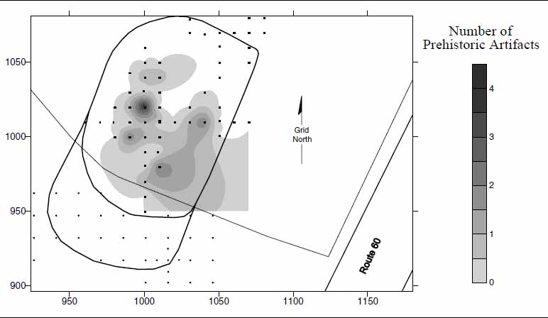 Figure 17. Distribution of prehistoric artifacts across 44JC1040.
44
in search of food resources. The site location, and the low density of artifacts, suggests that the prehistoric occupation of 44JC1040 was likely limited to a seasonal procurement campsite, used for gathering food resources during various parts of the year.
Figure 17. Distribution of prehistoric artifacts across 44JC1040.
44
in search of food resources. The site location, and the low density of artifacts, suggests that the prehistoric occupation of 44JC1040 was likely limited to a seasonal procurement campsite, used for gathering food resources during various parts of the year.
Chapter 6.
44JC1041
Results and Interpretations
A large multi-component site, 44JC1041 contains evidence of four distinct components within the site boundaries, two historic (Loci 1 and 2), and two prehistoric (Loci 3 and 4). The site area encompasses two raised flat terraces that define the eastern and western limits of the site. Both terraces overlook, to the north, the ravine leading toward Tutter's Neck Pond. Laying between the two terraces is a shallow gully that gradually slopes to the north, ultimately draining into the same ravine (Figure 18). Within the ravine to the north, a small creek flows west toward Tutter's Neck Pond. The creek within the ravine lies approximately 50 meters north of the site, and represents the closest available source of water to the site. Similar to 44JC1040, the vegetative cover
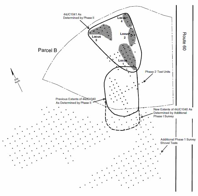 Figure 18. Site map of 44JC1041.
46
Figure 18. Site map of 44JC1041.
46
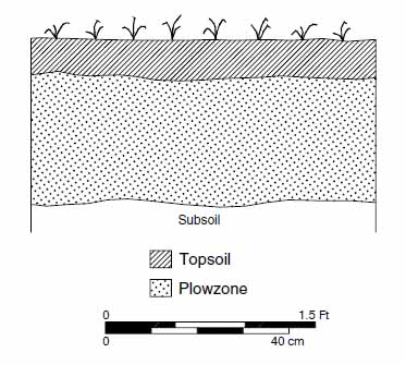 Figure 19. Typical soil profile for the area on top of the terraces, 44JC1041.
across the site is primarily secondary deciduous forest, consisting primarily of oak and holly trees. Understory vegetation covering the gound surface, consisting of briars and poison ivy, was relatively abundant across all portions of the site, but was especially dense within the bottom of the gully.
Figure 19. Typical soil profile for the area on top of the terraces, 44JC1041.
across the site is primarily secondary deciduous forest, consisting primarily of oak and holly trees. Understory vegetation covering the gound surface, consisting of briars and poison ivy, was relatively abundant across all portions of the site, but was especially dense within the bottom of the gully.
The soil stratigraphy of 44JC1041 included two different profiles. On top of the eastern and western terraces, the general soil profile consisted of a silt loam topsoil (10YR3/2), over a sandy loam plowzone (10YR5/4), over a sandy clay subsoil (10YR6/8) (Figure 19). The profile indicates that the area of the site on top of the terraces has been previously plowed. The majority of the artifacts recovered (both historic and prehistoric) from the terraced portions of the site were typically collected from the plowzone layers. Alternatively, the soil profile from within the gully included a general soil profile of a silt loam topsoil (10YR3/2), over a sandy loam plowzone (10YR5/4), over a deep layer of silt (10YR3/2), finally over a sandy clay subsoil (10YR6/8) (Figure 20). The deep silt
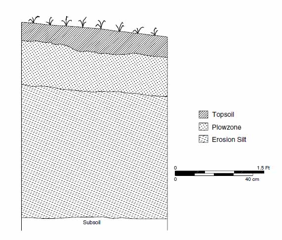 Figure 20. Typical soil profile for the area within the gully, 44JC1041.
47
layer is the result of soils from the tops and sides of the adjacent terraces eroding into the gully.
Figure 20. Typical soil profile for the area within the gully, 44JC1041.
47
layer is the result of soils from the tops and sides of the adjacent terraces eroding into the gully.
The previous Phase I investigation identified 44JC1041 as a multi-component site with three distinct concentrations of Native American, seventeenth-century, and eighteenth-century material, suggesting various occupations across overlapping portions of the site. The Native American artifacts were concentrated on the western terrace, and included grit and sand tempered ceramics and quartzite debitage suggesting a Middle Woodland occupation. The seventeenth-century artifacts included tobacco pipe fragments, white sandy earthenware, brick fragments, and nails. The seventeenth-century artifacts were primarily recovered from shovel tests within the south end of the gully. Meanwhile, the eighteenth-century ceramics were concentrated on top of the upper slopes of the eastern terrace. Creamware, wine bottle glass, brick, and nails were all recovered from tests from within this area. As a result of the Phase I findings, a Phase II archaeological assessment of 44JC1041 was recommended in order to more clearly delineate the boundaries of the site, to better define the age of the site's occupation, and to determine the integrity and significance of the site's preserved remains (Kostro 2000).
The Phase II archaeological assessment of 44JC1041 began on August 7, 2000, and consisted of a total of sixty-two 75-cm-square test units. The assessment confirmed the previous identifications of a Middle Woodland Native American, seventeenth-century, and eighteenth-century occupations at the site. In addition, a previously undetected additional Middle Woodland Native American site was also identified at the site. Each of the site's four occupations (Loci 1 through 4) are discussed individually in the following paragraphs.
Locus 1—Late Seventeenth-Century Occupation
Locus 1 represents a late seventeenth-century domestic occupation of the site (Figure 18). The seventeenth-century locus is situated within the gully descending from south to north into the deep ravine to the north that eventually drains west into Tutter's Neck Pond. The occupation at Locus 1 is defined based on the distribution of a variety of middle to late seventeenth-century artifacts (n=457) recovered from an area measuring approximately 70 × 30 m (2100 square meters). No features associated with the seventeenth-century occupation were located here.
Artifacts
The artifact assemblage for Locus 1 consists of both domestic and architectural materials. The domestic assemblage at Locus 1 includes ceramic sherds, wine bottle and container glass fragments, tobacco pipe stems and bowls, ammunition, and bone fragments among others. The architectural materials were exclusively nails. Brick was also recovered in substantial quantities, but is not included within the total artifact assemblage because it was quantified by weight, rather than by the number of fragments.
Only thirty ceramic sherds were recovered from Locus 1 at 44JC1041 (Table 3). English delfware (n=12) represented the largest quantity of any ceramic type. Stonewares (n=8), all of which were originally imported form Germany, along with local and imported earthenwares (n=8) were the second most common types of ceramics. Finally, two fragments 48
| WARE TYPE | QUANTITY | WARE TYPE | QUANTITY |
|---|---|---|---|
| Earthenwares | Stonewares | ||
| Local wares | 3 | Westerwald | 4 |
| Imported wares | Other German | 4 | |
| Staffordshire Mottled | 1 | ||
| North Midlands slipware | 4 | Porcelain | |
| Chinese | 2 | ||
| Tin-Enamled Wares | |||
| English delftware | 12 | TOTAL | 30 |
Among glass artifacts, dark green wine bottle glass fragments (n=30) were the most common type recovered. On seventeenth-century historic sites, wine bottles fragments typically do not appear on sites until after 1650. Six additional fragments of clear container glass were also recovered from tests within Locus 1. No additional glass fragments of any kind were recovered from the locus.
Locally manufactured and imported tobacco pipe bowl and stem fragments were the most common artifacts recovered from Locus 1 (n=97). Locally manufactured pipes (n=21), also known as Chesapeake pipes, make up 21.5% of the total tobacco pipe assemblage. Imported tobacco pipe fragments (n=76) make up the remainder of the assemblage (78.5%). Of special note, the stamped mark of tobacco pipe maker Llewellin Evens was found on two of the pipe stem fragments found at Locus 1. Evans is known to have produced pipes bearing this mark in Bristol, England beginning in 1661 (Walker 1977:1131). Tobacco pipes bearing the identical maker's mark were also recovered from other local seventeenth-century sites at CG-10, at nearby Carter Grove (Moody 1992:54), and at Utopia Quarter at Kingsmill (Fesler 2000:90). Additional information on the age of Locus 1 is discussed in the following paragraphs on site dating. The remaining miscellaneous domestic artifacts includes lead alloy shot, lead alloy casting waste, a small quantity of animal bone, and a few fragments of oyster shell.
Architectural artifacts from Locus 1 consisted entirely of nails and brick. A total of 230 wrought nails, and nail fragments, were recovered at Locus 1. Brick fragments from the locus were weighed, rather than counted, and measured 491 g (1.08 lb).
49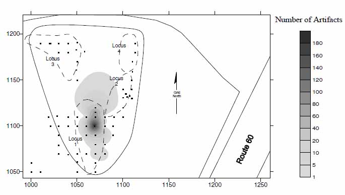 Figure 21. Distribution of artifacts within Locus 1, 44JC1041.
Artifact Distribution
The extent of Locus 1 was determined by plotting the distribution of seventeenth-century artifacts at the site (Figure 21). Unfortunately, all the seventeenth-century material was recovered only from test units within the gully that runs through the middle of the site. Furthermore, the majority of the artifacts were recovered from the deep layers of erosion silt. The soil layers containing the seventeenth-century material resulted from either the erosion of the surrounding terraces or the material being disposed of into the gully. As a result, Locus 1 represents merely the secondary deposition of the artifacts. The point of origin of the artifacts, or source of the artifacts, lies atop of one of the surrounding eroding terraces. However, pinpointing which of the terraces the artifacts were originating from is uncertain. No sub-surface features relating to a seventeenth-century occupation were identified. Potential sources of the seventeenth-century material are the tops of the terraces to the southeast and west of Locus 1.
Site Dating
To determine the age and duration of the occupation at Locus 1, the various techniques of site dating using ceramics and tobacco pipe stem fragments, previously discussed in the section on the dating of site 44JC1040, were similarly applied. Ceramics from the site were used to determine both a TPQ and mean ceramic date. Based on a single ceramic sherd of Staffordshire Mottled coarse earthenware, the TPQ of Locus 1 was determined to be 1680, thus representing the earliest possible date that the site could have been abandoned. Following Stanley South's (1977) method of determining a mean ceramic date, the date of Locus 1 was calculated to 1678. The mean ceramic date for Locus 1 was based on 23 of the 30 ceramics (69%). Seven ceramic sherds were not included within the analysis because their identifications were not specific enough to assign them to a particular date range.
50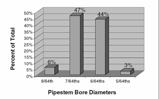 Figure 22. Tobacco pipe stem bore diameters from Locus 1, 44JC1041.
Tobacco pipe stem fragments were also utilized as a means of dating Locus 1. Of the imported tobacco pipe fragments, 32 fragments out of a total of 76 were stems with measurable bore diameters. Pipestems with bore diameters measuring 7 64ths (n=15) and 6 64ths (n=14), of an inch were nearly equal in number, and were the most common sized pipestem fragments recovered from Locus 1. Pipestems measuring 8 64ths and 5 64ths were also found but in only minimal quantities. The quantities of the varying pipestem bore sizes are illustrated in Figure 22.
The distribution of pipestem bore diameters at Locus 1 does not resemble any singular time period as indicated the histogram chart developed by J.C. Harrinton. Instead the distribution of pipestems at Locus 1 almost perfectly straddles two periods, 1650-1680 and 1680-1710, according to Harrington's histogram chart. Therefore, it is inferred that the occupation of Locus 1 was temporally centered around the date of 1680. Distributions straddling over multiple periods of the Harrington histogram have been suggested to be indicators of a long period of occupation of a site (Stone 1977 in Edwards and Brown 1993:292). Thus, the occupation of Locus 1 may potentially span the relatively long period between 1650 and 1710.
Alternatively, by applying Binford's straight-line regression formula to the pipe stem data, the calculated mean date for Locus 1 is 1680.77. Finally, as previously mentioned, the recovery of two tobacco pipe stem fragments with Llewelyn Evens maker's marks, dating to after 1661, further indicates a second half of the seventeenth century date for the occupation of Locus 1.
Somewhat surprisingly, each dating technique independently determined a date centering on 1680 for the occupation of Locus 1. The 1680 TPQ date is also indicative of the earliest possible date of abandonment of the site, although the Harrington histogram suggests that the occupation may have extended as late as 1710. However, the absence of certain late seventeenth-century and early eighteenth-century wares (i.e., Fulham stoneware, Challis local coarse earthenware, dipped white salt-glazed stoneware, etc), strongly indicates that the occupation of the site did not extend beyond 1700. The data also indicates 51 that a beginning date of the occupation of the site is no earlier than 1650, based on both Harrington histogram dates, and the recovery of substantial quantities of wine bottle glass (TPQ=1650). Based on all the above mentioned data, a realistic date range for the occupation of Locus 1 is a forty year period beginning around 1660 and continuing until ca. 1700.
Historical Context
In the second half of the seventeenth century the area of Locus 1 was potentially part of a large 700-acre tract of land at Tuttey' Neck, patented by Humphrey Higginson in 1637. In 1665, the 700-acre tract was inherited by Humphrey Higginson's brother, Christopher Higginson. Christopher Higginson owned the property until his death in 1673. After 1673, it is unclear who owned the land. By the final quarter of the century, four other individuals are known to have owned portions of Tuttey's Neck. In 1679, Edward Gray sold a parcel of land at "Tuttis Neck" to William Smith of Gloucester County. Unfortunately, no description of the property's size, boundaries, or how Gray acquired the property has survived. Three years later, Otho Thorpe bequeathed in his will to his cousin John Grice a plantation called "Tuttis Neck." Once again, however, no property description, or how Thorpe acquired "Tuttis Neck" has survived.
Summary
The seventeenth-century occupation of Locus 1 is characterized by the recovery of a variety of artifacts dating to the second half of the seventeeth-century. The artifacts were all recovered from an area measuring 70 × 30 m (2,100 square meters) within a small gully sloping north into a deep ravine. All the seventeenth-century material was recovered from silt layers within the gully that had eroded or been tossed down from the tops of the adjacent terraces. Consequently, Locus 1 represents merely the secondary deposition of the artifacts. The artifacts primary point of deposition, or origin, lays atop of one the surrounding terraces. However, pinpointing on which of the terraces the artifacts have originating from is difficult. No sub-surface features relating to a seventeenth-century occupation were identified. Nevertheless, the source of the seventeenth-century material rests undoubtedly, on the top of one of the terraces to the southeast and west of Loucs 1.
The artifacts indicate that Locus 1 was most likely a domestic site. Additionally, the recovery of expensive and highly coveted ceramics (i.e., porcelains) suggest that the occupants of the locus were of the middle to upper class. Finally, based on a diversity of archaeological dating techniques, the occupation of the site was determined to have centered around the year 1680. The duration of the site occupancy is mostly likely to have spanned the period between 1660 and 1700.
The combination of the archaeological and historical data suggests that Locus 1 is associated with one or more of the late seventeenth-century property owners at Tuttey's Neck. Among the potential individuals who may have occupied the site are, Christopher Higginson (1665-1673), Edward Gray (???-1679), William Smith (1679-???), Otho Thorpe (???-1682), or John Grice (1682-???).
| Feature # | Unit Coordinates | Context #'s | Feature Description | ||
|---|---|---|---|---|---|
| 1 | 1130N/1110E | 51AD-102-103 | Modern utility trench | ||
| 2 | 1135N/1103E | 51AD-123-129 | Possible brick chimney base or hearth | ||
| 1135N/1102.25E | |||||
| 3 | 1132N/1104E | 51AD-132-133 | Square-shaped feature—possible posthole | ||
| 4 | 1133N/1107E | 51AD-137-138 | Square-shaped posthole w/postmold | ||
| 5 | 1131N/1100E | 51AD-109-110 | Large unknown feature |
Locus 2—Mid Eighteenth-Century Occupation
Locus 2 represents a mid-eighteenth-century domestic occupation of 44JC1041 (see Figure 18). Locus 2 is situated northeast of Locus 1, on top of the narrow flat terrace that defines the eastern extent of 44JC1041. Locus 2's occupation is defined based on the distribution of 212 mid-eighteenth-century artifacts, and a heavy concentration of brick recovered from an area measuring approximately 30 × 40 meters (1,200 square meters). Additionally, a small number of features (n=5), including a possible brick chimney base or hearth, were identified within the boundaries of the Locus 2.
Feature Descriptions
Four different subsurface features were discovered within the area of Locus 2. The features were number one through five, and are listed with summary descriptions in Table 4. One of the features (Feature 1) is a modern disturbance, while the remaining four are all potentially associated with the mid-eighteenth century occupation of Locus 2. None of the features were excavated as part of the Phase II fieldwork.
Feature 1 is a modern sewer utility trench, orientated north-south, along the top of the eastern ridge of the terrace that defines the eastern boundary of 44JC1041. Locus 2 is also located along the ridge, on top of the same terrace. The edge of the utility trench was exposed in test unit 1130N/1110E. To the north and south of the test unit, a shallow depression at ground surface indicated the trench's location extending north and south out of the locus area along the terrace. Unfortunately, the installation of the sewer line is likely to have destroyed any intact eighteenth-century soil layers and features laying the path of the sewer line. Approximately 25% of the area of Locus 2 appears to have been impacted by the sewer line.
A large brick feature (Feature 2) was partially exposed within two adjoining 75-cm-square test units (1135N/1103E and 1135N/1102.25E) (Figure 23). Significantly, in the course of the excavation, the test units were observed to be situated directly on top of a small raised mound. Littering the entire surface of the mound was a substantial scatter of brick fragments. Within the test units, a thin layer (5-15 cm) of topsoil, containing heavy quantities of brick fragments, was removed to expose a dense layer of brick and shell
53
 Figure 23. Plan view of possible brick chimney base or hearth (Feature 2) at Locus 2, 44JC1041.
mortar rubble. Within the brick and mortar rubble layer, as well as within the above layer of topsoil, several compass bricks and compass brick fragments used for lining wells were observed. Often times, once a well went out of use the bricks lining the well were often times retrieved and reused elsewhere, including being incorporated into crude foundations or as part of chimneys and fireplaces.
Figure 23. Plan view of possible brick chimney base or hearth (Feature 2) at Locus 2, 44JC1041.
mortar rubble. Within the brick and mortar rubble layer, as well as within the above layer of topsoil, several compass bricks and compass brick fragments used for lining wells were observed. Often times, once a well went out of use the bricks lining the well were often times retrieved and reused elsewhere, including being incorporated into crude foundations or as part of chimneys and fireplaces.
Partially visible beneath the layer of brick and mortar rubble, several courses of brick bond with shell mortar were observed. The bricks laying in course were orientated lengthwise approximately 45 degrees east of grid north (15 degrees west of magnetic north). The bricks appeared to continue in course to the southwest, out of the test units. To the northeast, the brick and mortar rubble overlaying the bricks obscured the extent of the bricks in course. Also exposed within test unit 1135N/1102.25E was a block of bricks mortared together. It remained unclear if the brick block was a complete element laying in situ or if the block had been broken off something else and landed in that location. Both the bricks in course and the brick block were laying on top of a layer of brown (10YR3/4) silt loam with charcoal, brick and shell inclusions. Artifacts, including a tobacco pipe stem, were observed lodged within the layer. The brick feature may represent a brick chimney base or fireplace hearth. However, the possibility that the feature may be part of a brick building foundation cannot be ruled out yet either. Unfortunately, not enough of the feature was exposed in order to make to accurately assess the feature's function at this time.
Two meters southeast of the brick feature, a square-shaped dark brown (10YR3/3) sandy loam feature (Feature 3) cut into the subsoil was observed in test unit 1132N/1104E (Figure 24). The feature measured 25 cm east-west and 30 cm north-south. Although no postmold was conclusively defined, the feature has been tentatively identified as a posthole.
Feature 4, partially exposed in test unit 1133N/1107E (Figure 25), is also thought to be a posthole. The feature measures 27 cm northwest-southeast and 40 cm northeast-southwest. The posthole fill is composed of brown (10YR3/3) sandy loam. Within the approximate center of the posthole is a round postmold impression of a former wooden post. Although difficult to determine its extent, the diameter of the mold measured approximately 20 cm across. The fill within the mold is a brown (10YR3/4) silt loam. The posthole may have once held a horizontal support post of a post-in-ground structure, or may have also supported a fence post for a fence line.
54 Figure 24. Plan view of possible posthole feature (Feature 3) in Test Unit 1132N/1104E, Locus 2, 44JC1041.
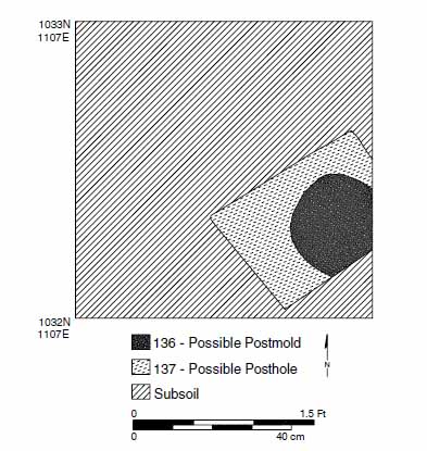 Figure 25. Plan view of possible posthole feature (Feature 4) in Test Unit 1133N/1107E, Locus 2, 44JC1041.
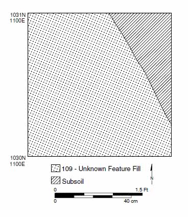 Figure 26. Plan view of unknown feature (Feature 5) in Test Unit 1131N/1100E, Locus 2, 44JC1041.
The final remaining feature at Locus 2 is a large feature identified in test unit 1131N/1100E (Figure 26). The feature fill consisted of an orange brown silty clay loam with brick flaking scattered throughout the fill. The feature covered approximately 85% of the test unit bottom. An edge of the feature was exposed in the northwest corner of the test unit. The feature extended out of the unit to the north, south, and east of the unit. As a result of the feature's large size, the dimensions and function of the feature remain undetermined.
Artifacts
A concentration of domestic artifacts, and a large quantity of architectural material composed the majority of artifacts recovered at Locus 2. The domestic artifacts included primarily ceramics, wine bottle and container glass, and a small number of tobacco pipe 55
| WARE TYPE | QUANTITY | WARE TYPE | QUANTITY |
|---|---|---|---|
| Earthenware | Stoneware | ||
| Coarse | White salt glazed | 11 | |
| North Midlands slipware | 1 | Westerwald | 1 |
| Buckley ware | 8 | Scratch blue | 2 |
| debased | 1 | ||
| Refined | American brown | 1 | |
| Whieldon refined | German | 1 | |
| Agate | 1 | ||
| Tortoiseshell | 1 | Porcelain | |
| Creamware | 20 | Chinese | 2 |
| Red agate | 2 | ||
| Tin-enameled | |||
| English delftware | 13 | TOTAL | 65 |
Sixty-five sherds of a variety of eighteenth-century ceramics were recovered from Locus 2 (Table 5). Earthenwares (n=33) were the most common ceramic type recovered. Included among the earthenwares were both coarsewares and refined earthenwares. Ware types included North Midlands slipware, Buckley ware, Whieldon refined agateware and tortiseshell-ware, creamware, and red-bodied agateware. All of the varieties of earthenwares were imported to Virginia from Europe. Stonewares (n=17) were the next most common ceramic type recovered at Locus 2. The varieties of stoneware included white salt glazed, Westerwald, scratch blue, American brown, and German stoneware. Most of the stonewares were originally manufacted in Europe, with the exception of the single fragment of American brown. English delftware (n=13) was the third most common type of ceramic, and Chinese porcelain (n=2) was recovered in a very small quantities.
Wine bottle glass (n=32) was also relatively common among the artifacts recovered from the site. Other forms of container glass (n=9) were also recovered from the site but in much smaller quantities. Only six total tobacco pipe fragments were recovered from Locus 2, and consisted entirely of imported pipes. The remaining domestic artifacts included a single copper-alloy upholstery tack, a copper-alloy button, and an agate stone jewelry pendant. The stone was engraved with a neo-classical profile image of a man's head. Etchings within the engraving indicate that the image had been cut by hand into the stone.
Among architecturally related material, brick and brick fragments were abundant (40,918.34 g, or 90.21 lb), although they have not been included within the artifact count. Sixty-eight nail and nail fragments were also recovered from Locus 2. A single window
56
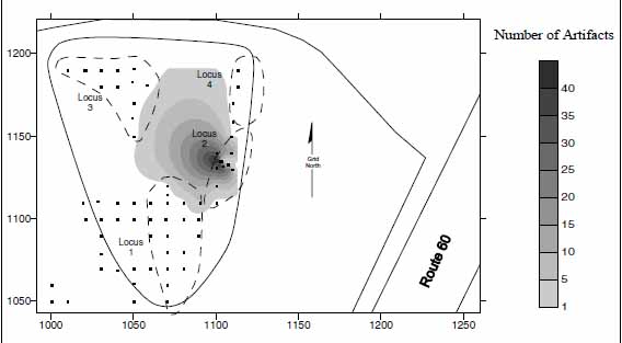 Figure 27. Distribution of eighteenth-century artifacts at Locus 2, 44JC1041.
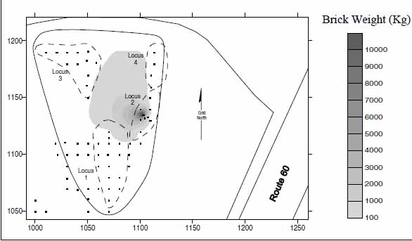 Figure 28. Distribution of brick and brick fragments at Locus 2, 44JC1041.
lead fragment was also recovered from a test unit within the locus. Surprisingly, however, only a single fragment of window glass was recovered from Locus 2.
Figure 28. Distribution of brick and brick fragments at Locus 2, 44JC1041.
lead fragment was also recovered from a test unit within the locus. Surprisingly, however, only a single fragment of window glass was recovered from Locus 2.
Artifact Distributions
The boundaries of Locus 2 were determined by plotting the distribution of all eighteenth-century artifacts across the locus (Figure 27). Within the distribution, a single large concentration of artifacts was centered at test unit 1132N/1104E. Brick fragments (measured by weight) were also plotted revealing a heavy concentration coinciding with the artifacts (Figure 28). In both cases, the eastern edges of the artifact and brick distributions are defined by the modern utility trench cutting through locus. Nevertheless, within the preserved portion of the locus, the brick and artifact clusters also coincide with the locations of features that may be related to a structure. The combination of all this data strongly suggests that a structure, most likely a dwelling, was located within Locus 2.
Site Dating
The latest TPQ date, representing the earliest possible date for the abandonment of Locus 2 is 1765. The date is based on a single sherd of debased "scratch blue" white salt glazed stoneware recovered from test unit 1133N/1107E. The mean ceramic date was calculated based on sixty-three of the sixty-five ceramic fragments recovered from Locus 2. Two sherds were excluded from the analysis because they have unspecific date ranges. The mean ceramic date for Locus 2 was calculated at 1764.35.
Unfortunately, only three tobacco pipe stems with measurable bore diameters were recovered from the Locus. Two of the pipe stems had bore diameters of 4 64ths of an inch, and one had a diameter of 5 64ths of an inch. Due to the very small sample size of tobacco pipes at Locus 2, a Harrington date range could not be reliably determined. In general, however, tobacco pipe stems with bore diameters of 4 64ths were the most common between 1750 and 1800. Similarly, the sample size is too small for a reliable estimate of the occupation date using Binford's straight-line regression technique. Nonetheless, using Binford's formula, a date of 1766.07 was calculated for Locus 2 based on the limited sample. Once again, however, the small sample size limits the reliability of the Binford formula derived date.
The limited ceramic and tobacco pipe stem information suggests that the occupation of the site was concentrated during the third quarter of the eighteenth century. Significantly, few artifacts predating 1720 were recovered form Locus 2, yet artifacts typical of second and third quarter eighteenth century sites were common. As a result, the occupation of Locus 2 most likely started after 1720, and continued through the second quarter and into the third quarter of the century. The 1765 TPQ-date for the site indicates that the site was abandoned sometime after that date. Furthermore, Jean Nicholas Desandrouins' Revolutionary War map of the Williamsburg area (see Figure 3) does not indicate a structure within the area, suggesting that the site was no longer occupied by that date. Additionally, not a single artifact (i.e., pearlware) typically found on fourth quarter eighteenth-century sites was recovered. The absence of these late eighteenth-century artifacts suggests that the occupation of Locus 2 did not extend into the fourth quarter of the century, indicating a probable terminal date for Locus 2 of ca. 1775.
Historical Context
In the mid-eighteenth century, Locus 2 may have been part of the large tract of land owned by the Bray family, known as Tuttey's Neck. Although the Brays may have owed the land, they most likely did not live on the land. However, tenant farmers, overseers, farm managers, and slaves working the land were likely have lived on the property on which they worked.
In 1720, a 300-acre tract of land known as Tuttey's Neck was inherited by David Bray II, from his mother Judith Bray. After David Bray II's death in 1732, the property was acquired by Thomas Bray II. By 1740, Thomas Bray II had employed at least two plantation managers, John Green and Benjamin Tureman, to oversee the operations on the family's properties at Tuttey's Neck and Utopia near the James River. Benjamin Tureman is believed to have worked the land at Tuttey's Neck. Tureman may have maintained a house on the property during his management of the farming operations there. In 1751, 58 Thomas Bray II died, and his daughter Elizabeth Bray Johnson inherited the property. After her death in 1765, the property was inherited by her husband Col. Philip Johnson. Col. Johnson advertised to property for sale in 1771 in the Virginia Gazette. The newspaper advertisement listed the property as including, "all necessary Houses of Cropping." The property is hypothesized to have been sold soon after the advertisement.
Summary
The mid-eighteenth-century occupation of Locus 2 is characterized by the recovery of 212 artifacts dating the second and third quarter of the eighteenth century. An estimated 25% of the locus has been destroyed as a result of the installation of a sewer line through the area. Nevertheless, within the preserved portion of the site, several features associated with the mid-eighteenth century occupation of the site were identified, including a large brick structural feature, postholes, and an unknown feature. The features are compelling evidence that a structure once stood at the site. Information gleaned from the artifact analysis suggests a domestic occupation approximately spanning a 50-year period between 1725 and 1775. During this time, the limited historical information suggests that this area was the property of various members of the Bray family. During the Brays' ownership, various tenants, plantation managers and slaves would have lived and worked on the land. Among the Bray family's different plantation managers, Benjamin Tureman, is recorded as having managed the Bray family operations at Tuttey's Neck. The mid-eighteenth-century occupation of Locus 2 corresponds with Turemans tenure at Tuttey's Neck, and the site may be the remains of Tureman's residence. Alternatively, the locus may have been occupied by various Bray family slaves, working at Tuttey's Neck under Tureman's supervision.
Locus 3—Early/Middle Woodland Native American Occupation
Locus 3 is the site of a Native American seasonal procurement camp(s), dating to the Early to Middle Woodland period (3,200-1,100 BP). The locus is located northwest of Locus 1, on top of a flat terrace overlooking to the north the ravine that leads west to Tutter's Neck Pond. Locus 3's area measures approximately 2,000 square meters, defined by the recovery of 100 prehistoric artifacts from thirteen different test units (see Figure 18). Several small sub-surface features possibly associated with the site's Middle Woodland occupation were also identified.
Feature Descriptions
Three features possibly dating the Early/Middle Woodland Native American occupation at Locus 3 were identified cutting into the subsoil in test units 1183N/1049E, 1190N/1020E, and 1190N/1020.75E (Figure 29). The features were roughly square with rounded corners or round, and measured between 20 and 25 cm in diameter. The fill within each of the features was a dark brown (10YR3/2) silt loam.
To distinguish if the features were natural (i.e., root stains) or cultural (i.e., postholes), one of the features was excavated. The vertical profile of the feature was V-shaped, extending to a depth of 41 cm below the surface of the subsoil (Figure 30). Inclusions of
59
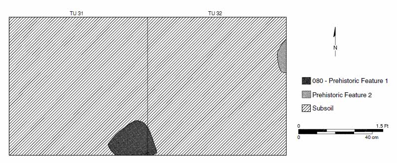 Figure 29. Middle Woodland features within Test Unit 1190N/1020E and 1190N/1020.75E, Locus 3, 44JC1041.
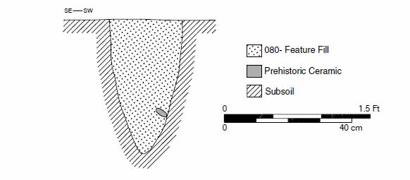 Figure 30. Profile of excavated feature at Locus 3, 44JC1041.
charcoal were evident in the feature fill. A single fragment of Native American pottery was recovered from the bottom layers of fill of the feature. The recovery of the sherd suggests that the feature is most likely related to the Native American occupation. The function of the feature, however, remains uncertain.
Figure 30. Profile of excavated feature at Locus 3, 44JC1041.
charcoal were evident in the feature fill. A single fragment of Native American pottery was recovered from the bottom layers of fill of the feature. The recovery of the sherd suggests that the feature is most likely related to the Native American occupation. The function of the feature, however, remains uncertain.
Artifacts
A total of 101 prehistoric artifacts, consisting of both lithics (n=22) and ceramics (n=78), were recovered from Locus 3. Included among the lithic artifacts was a narrow stemmed quartz projectile point. Based on morphological and stylistic similarities, the point most closely resembles the Yorktown Stemmed type. Yorktown Stemmed points are possibly related to Savannah River types. Both the Yorktown Stemmed type and the Savannah River type points are commonly found on Late Archaic/Early Woodland prehistoric sites.
The tip of a quartzite projectile point was also recovered from Locus 3. Unfortunately, not enough of the point was recovered to ascribe it to a particular style or tradition of manufacturing. Quartz and quartzite debitage (n=12) constituted the majority of the lithics from the locus, and the remainder of the lithic assemblage was composed of fire cracked rock (n=8).
60Seventy-eight ceramic fragments of Native American pottery were recovered from Locus 3. The majority of the sherds (n=66) are sand and crushed quartz tempered wares. The remaining sherds (n=13) are all grit tempered. Surface treatments, including net impressions and cord marking, were evident on eighteen of the sand and crushed quartz tempered ceramics. The majority of the ceramic fragments (n=43), however, had either degraded or eroded surfaces, obscuring any potential surfaced treatment. The remaining five fragments exhibited no evidence of any surface treatment. Among grit tempered ceramic fragments, four fragments had cord marked surface treatments, three fragments with no surface treatment, and six fragments with degraded or eroded surfaces. Based on the temper and surface treatments, all the ceramics recovered from Locus 3 resemble Varina pottery types, dating to the Middle Woodland period.
Artifact Distribution
Within Locus 3, two distinct concentrations of prehistoric artifacts are evident in the distribution of artifacts across the locus (Figure 31). Remarkably, the locations of the artifact concentrations coincide with the locations of features. The coincidence of the artifact concentrations and feature locations suggests that these areas may represent individual activity areas within the locus, or that they may represent two occupations of the locus from different time periods.
Summary
Locus 3 is an Early to Middle Woodland (3,200-1,100 BP) Native American site. The age of the site was determined on the basis of the recovery of a diagnostic artifacts including a Early Woodland Yorktown Stemmed projectile point, and large quantity of Middle Woodland Varina type pottery fragments.
During this period, Native Americans in Virginia had began to organize themselves into tribal rather band-level societies. Early to Middle Woodland settlement patterns are characterized by, semi-sedentary base camps, with satellite collector sites. The larger base camps were typically located near a salt/fresh water interface, while the small satellite camps were placed along streams and used for collecting during the various parts of the year. Subsistence was based on a heavy reliance on local plants, small game, and fish and oysters. By the Middle Woodland, Native Americans are believed to have begun to selectively nurture, or possible even domesticate, local plants. Finally, the introduction of ceramic bowls during the Woodland period was a major technological innovation during this period.
The inland location of Lucus 3 near the head of a small creek suggests that the site was a seasonally inhabited procurement, or satellite camp. The high incidence of Middle Woodland ceramics, the presence of fire cracked rock, and the identification of at least one feature, all suggest that the site was occupied for an extended duration. Finally, the bimodal distribution of the artifacts within Locus 3 suggests either two distinct contemporary activity areas, or more likely, multiple reoccupations of the same site area.
61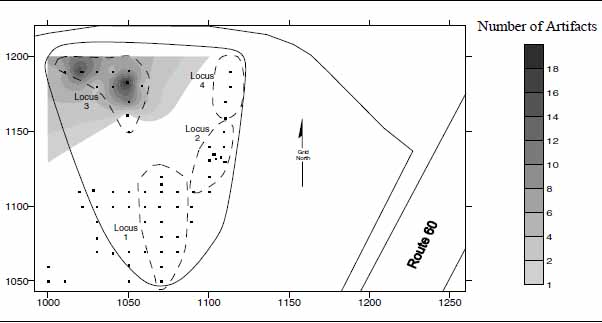 Figure 31. Distribution of prehistoric artifacts from Locus 3, 44JC1041.
Locus 4—Early-Middle Woodland Native American Occupation
Locus 4 is another Native American seasonal procurement camp, dating to the Early to Middle Woodland period (3,200-1,100 BP), although it is much smaller than Loucs 3. A gully separates the two seemingly contemporary Native American sites at Loci 3 and 4. The locus is situated on the northern tip of a flat narrow terrace overlooking the ravine to the north that drains into Tutter's Neck Pond to the west (see Figure 18). The area of the size measures 20 × 50 meters (1,000 square meters), and overlaps slightly with the mid-eighteenth century component at Locus 2 to the south. The site was determined based on the recovery of sixteen Early and Middle Woodland period lithic and ceramic artifacts from six test units. No features were identified within the locus.
Artifacts
Only sixteen artifacts, consisting of both lithics (n=9) and ceramics (n=7), were recovered from Locus 4. Included among the lithic artifacts was another narrow stemmed quartz projectile point. Based on morphological and stylistic similarities, the point most closely resembles Yorktown Stemmed projectile points. A similar point was recovered from Locus 3. As mentioned earlier, Yorktown Stemmed projectile points may related to Savannah River points. Both the Yorktown Stemmed type and the Savannah River type points are commonly found on Late Archaic/Early Woodland prehistoric sites. Four quartzite debitage flakes and four pieces of fire cracked rock were also recovered.
The Native American pottery from Locus 4 consists entirely of seven sand and crushed quartz tempered ceramic fragments. Surface treatment on six of the pieces pottery was cord or textile impressed. The surface of one fragment was too deteriorated to determine the type of surface treatment on the seventh pottery fragment. Based on the temper and surface treatments, all the ceramics recovered from Locus 4 resemble Varina pottery types, dating to the Middle Woodland period.
62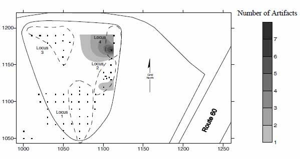 Figure 32. Distribution of prehistoric artifacts from Locus 4, 44JC1041.
Artifact Distribution
The small quantity of prehistoric artifacts at Locus 4 forms a single concentration near the northern tip of the small terrace (Figure 32). Isolated prehistoric artifacts were also located to the south within Locus 2. The modern sewer line observed along the eastern side of Locus 2, also extends along the eastern side of Locus 4. Most likely, the eastern portion of Locus 4 was also probably destroyed as a result of the sewer line installation.
Summary
Based on archaeological evidence, Locus 4 is another Early to Middle Woodland (3,200-1,100 BP) Native American site. Similar to Locus 3, the age of the site was determined on the basis of the recovery of diagnostic artifacts, including a Early Woodland Yorktown Stemmed projectile point, and large quantity of Middle Woodland Varina type pottery fragments. The inland location of Locus 4 near the head of a small creek, and the small number of tightly clustered artifacts, suggests that the site was a seasonally inhabited procurement, or satellite camp.
Chapter 7.
Conclusions and Recommendations
In summary, between July 25 and September 1, 2000 the Colonial Williamsburg Foundation's Department of Archaeological Research conducted Phase II archaeological assessments of two sites located southeast of Colonial Williamsburg's Historic Area, along Route 60. The sites were originally identified during a 1999 archaeological survey of the property by Colonial Williamsburg Foundation archaeologists (Kostro 2000). The Phase II assessments were designed to delineate the boundaries of the sites, to better define their respective periods of occupation, and to determine the integrity and significance of each of the sites' preserved remains.
Site 44JC1040 is a multi-component site with evidence of both colonial and Native American occupations. The historic component of the site was based on the recovery of a large quantity of late seventeenth and early eighteenth-century artifacts, as well as, the discovery of a small number of intact subsurface features. Analysis of the artifacts suggests a date range of ca. 1690 to ca. 1740 for the occupation of the site. The artifact analysis further indicates that the occupants of the site were most likely of middle income status. Distribution analysis of the seventeenth- and eighteenth-century artifacts from across the site revealed two distinct concentrations within the site boundaries. The presence of a large number architecturally-related artifacts within these two concentrations further suggests that buildings once existed at both locations. Several intact features relating to the structures were also identified, including a possible root cellar, a ditch or trench, and several postholes. Historical research suggests that the site was owned possibly by Frederick Jones and later by the Bray family during this period. Based on the archaeological evidence and limited historical data, the most likely inhabitants of 44JC1040 were probably tenant farmers or overseers of either Frederick Jones or the Bray family.
The Native American component of site 44JC1040 is characterized by a light scatter of artifacts dating to the Archaic period (10,000-3,200 BP). The site location, and low density of the artifacts, suggests that the Native American occupation of the site was limited to a seasonal procurement campsite used for gathering food resources during various parts of the year.
The results of the Phase II assessment show that 44JC1040 is a multi-component site with the remains of an early colonial plantation site, as well as an Archaic-period Native American encampment. Both of these associations make the site highly significant in terms of the criteria of National Register of Historic Places. As a result, avoidance of site 44JC1040 is recommended in order to preserve what is left of this important site for future generations. If there exists no options for site avoidance, a Phase III data recovery excavation of site 44JC1040 will be necessary prior to any further alteration to, or construction on, the property.
Site 44JC1041 is a large multi-component site with evidence of four distinct components, two historic (Loci 1 and 2), and two prehistoric (Loci 3 and 4). Locus 1 represents domestic occupation spanning the period between 1660 and 1700. The locus was identified based on variety of middle to late seventeenth-century artifacts recovered primarily from silt layers within a gully descending from south to north into a deep ravine. The soil 64 layers containing the seventeenth-century material resulted from either the erosion of the surrounding terraces or the material being disposed of into the gully. The point of origin of the artifacts, or source of the artifacts, lies atop of one of the surrounding eroding terraces. Scant traces of potential sources of the seventeenth-century material were revealed on top of the terraces to the southeast and west of Locus 1. These areas probably contain the structures associated with the material found in the ravine. The site may be the remains of a seventeenth-century slave quarter or the home of an English-born indentured servant/tenant. Historical research of the property has identified at least five different potential property owners in the late seventeenth century. Among the individuals who may have occupied Locus 1 are Christopher Higginson, Edward Gray, William Smith, Otho Thorpe, and John Grice.
Locus 2 consists of a mid-eighteenth-century domestic occupation. Locus 2 is located northeast of Locus 1, on top of a narrow flat terrace. An estimated 25% of the locus has already been destroyed as a result of the installation of a sewer line through the area. The preserved portion of the locus was characterized by small cluster of mid-eighteenth century artifacts, and a heavy concentration of brick. Several features relating to a possible structure were also identified at the site, including a possible chimney base, postholes, and a large feature of an undetermined function. Analysis of the artifacts suggest an occupation approximately spanning a 50-year period between 1725 and 1775. Historical research suggests that that this area was the property of various members of the Bray family. During the Brays' ownership, various tenants, plantation managers and slaves would have lived and worked on the land. It is possible that Locus 2 is the remnants of one such individual or household living on land owned by the Bray family.
Locus 3 is a Native American seasonal procurement camp, dating to Middle Woodland period (2500-1100 BP). The locus is located northwest of Locus 1, on top of a flat terrace overlooking a ravine. Artifacts recovered from within the locus consisted of a large number of Native American pottery fragments, a complete projectile point, and the tip of another projectile point. A small quantity of lithic debitage and fire-cracked rock was also recovered from the area. In addition to the artifacts, several small features possibly related to the site's Native American occupation were also identified and recorded.
Locus 4 is another Native American seasonal procurement camp dating to the Middle Woodland period (2500-1100 BP), although it is much smaller than Locus 3. A gully separates the two seemingly contemporary Native American sites at Loci 3 and 4. The locus is situated at the northern tip of flat narrow terrace overlooking the ravine to the north that drains into Tutter's Neck Pond to the west. Locus 4's horizontal extent overlaps slightly with the mid-eighteenth century component at Locus 2 to the south. Similar to Locus 3, artifacts from Locus 4 consisted of Middle Woodland period pottery fragments, lithic debitage, fire-cracked rock, and another complete projectile point. No features were identified within the locus.
44JC1041 is a complicated site with a long history of multiple occupations that span from prehistoric times and extend into the mid-eighteenth century. The presence of these four occupations, two prehistoric and two of the colonial period, makes site 44JC1041 eligible to the National Register of Historic Places. As with site 44JC1040, avoidance of site 44JC1047 also recommended in order to preserve what is left of the site for future generations. If there exist no options for site avoidance, a Phase III data recovery 65 excavation will be needed for Site 44JC1041 prior to any further alteration to, or construction on, the property.
66Bibliography
- 1992
- Archaeological and Ethnographic Evidence of Subsistence in Virginia during the Late Woodland Period. In Middle and Late Woodland Research in Virginia: A Synthesis, edited by Theodore R. Reinhart and Mary Ellen N. Hodges, pp. 225-248. The Dietz Press, Richmond.
- 1962
- A New Method of Calculating Dates From Kaolin Pipe Stem Fragments. Southeastern Archaeological Conference Newsletter 9(1).
- 2000
- Archaeological Survey of Jamestown Island. Jamestown Archaeological Assessment Technical Report Series. National Park Service, Colonial National Historical Park, Yorktown.
- 1986
- Toward a Resource Protection Process: James City County, York County, City of Poquoson, and the City of Williamsburg. Department of Archaeological Research, Colonial Williamsburg Foundation, Williamsburg.
- 1896
- Economic History of Virginia in the Seventeenth Century. 2 volumes. MacMillon and Company, New York.
- 1981
- Impermanent Architecture in the Southern American Colonies. Winterthur Portfolio 16(2/3):135-196.
- 1990
- Early and Middle Archaic Cultures of Virginia: Culture Change and Continuity. In Early and Middle Archaic Research in Virginia: A Synthesis, edited by Theodore R. Reinhart and Mary Ellen Hodges, pp.1-60. The Dietz Press, Richmond.
- 1987
- Harrington Histograms Versus Binford Mean Dates as a Technique for Establishing the Occupational Sequence of Sites at Flowerdew Hundred, Virginia. American Archaeology 6(1):62-67.
- 1988
- Flowerdew Hundred: The Archaeology of a Virginia Plantation, 1619-1864. University Press of Virginia, Charlottesville. 68
- 1781
- Carte des Environs de Williamsburg en Virginie ou les Armess Francoise et Americaine on Campes en Septembre 1781. Facsimile reprint. Colonial Williamsburg Foundation, Williamsburg.
- 1993
- Seventeenth-Century Chesapeake Settlement Patterns: A Current Perspective from Tidewater Virginia. In The Archaeology of Seventeenth Century Virginia, edited by Theodore R. Reinhart and Dennis J. Pogue, pp. 285-309. The Dietz Press, Richmond.
- 2000
- Back to Utopia: A Report on Renewed Archaeological Excavations at the Utopia Quarter, Field Seasons 1993-1996. Kingsmill on the James, James City County, Virginia. Period 1 Occupation, ca. 1670-1700. Volume I. James River Institute for Archaeology, Inc., Williamsburg.
- n.d.
- Field notes and survey maps on file at the Department of Archaeological Research, Colonial Williamsburg Foundation, Williamsburg.
- 1990
- The Early and Middle Archaic Periods: Material Culture and Technology. In Early and Middle Archaic Research in Virginia: A Synthesis, edited by Theodore R. Reinhart and Mary Ellen Hodges, pp.1-60. The Dietz Press, Richmond
- 1989
- Quarterpath Road and its Environs: What the Documentary Evidence Reveals. Manuscript on file, Department of Archaeological Research, Colonial Williamsburg Foundation, Williamsburg.
- 1958
- Kingsmill Plantation, James City County. Colonial Williamsburg Foundation, Williamsburg.
- 1995
- "Middle Plantation Settlement Patterns." Paper presented at the 1995 Society for Historical Archaeology conference, Washington, D.C.
- 1954
- Dating Stem Fragments of Seventeenth and Eighteenth Century Clay Tobacco Pipes. Quarterly Bulletin of the Archaeological Society of Virginia. 9(1):9-13.
- 1997
- A Pitiless Rain: The Battle of Williamsburg, 1862. White Mane Publishing Co., Inc. Shippensburg, Pa. 69
- 1997
- Archaeological Survey of the Proposed 199 Widening Project, James City County, Virginia. William and Mary Center for Archaeological Research, Williamsburg, Virginia. Submitted to the Virginia Department of Transportation.
- 1991
- The Late Archaic and Early Woodland Periods in Virginia: Interpretation and Explanation Within an Eastern Context. In Late Archaic and Early Woodland Research in Virginia: A Synthesis, edited by Theodore R. Reinhart and Mary Ellen N. Hodges. Pp 221-242. The Dietz Press.
- 1987
- Survey of James City and York Counties and the City of Williamsburg, Virginia. U.S. Department of Agriculture, Soil Conservation Service, Washington, D.C.
- 1984
- Kingsmill Plantations 1619-1800: Archaeology of Country Life in Colonial Virginia. Academic Press, New York.
- 2000
- Phase I Archaeological Survey of the Proposed Colonial Williamsburg Bus Facility. Colonial Williamsburg Archaeological Reports. Colonial Williamsburg Foundation, Williamsburg.
- 2000
- Nassau Street Site Summer 1999 Excavations. Colonial Williamsburg Archaeological Reports. Colonial Williamsburg Foundation, Williamsburg.
- 2000
- At the Edge of the Precipice: Frontier Venture, Jamestown's Hinterland, and the Archaeology of 44JC802. Association for the Preservation of Virginia Antiquities, Richmond.
- 1997
- James City County: Keystone of the Commonwealth. The Donning Company Publishers, Virginia Beach, Virginia.
- 1977
- Littletown Plantation, 1700-1745. Master's thesis, Department of History, College of William and Mary, Williamsburg, Virginia.
- 1992
- Virginia's Middle Woodland Period: A Regional Perspective. In Middle and Late Woodland Reseach in Virginia: A Synthesis, edited by Theodore R. Reinhart and Mary Ellen N. Hodges, pp. 39-64. The Dietz Press, Richmond. 70
- 1998
- "Upon the Palisado" and Other Stories of Place from Bruton Heights. Colonial Williamsburg Research Publications. Colonial Williamsburg Foundation, Williamsburg.
- 1992
- Phase II Archaeological Investigation of the Locust Grove Tract, Carter's Grove Plantation. Department of Archaeological Research, Colonial Williamsburg Foundation, Williamsburg.
- 1991
- The Formative Transition in Virginia. In Late Archaic and Early Woodland Research in Virginia: A Synthesis, edited by Theodore R. Reinhart and Mary Ellen N. Hodges, pp. 1-88. The Dietz Press, Richmond.
- 1966
- Excavations at Tutter's Neck in James City County, Virginia, 1960-1961. Contributions from the Museum of History and Technology, Paper 53. Smithsonian Institution, Washington, D.C.
- 1979
- Cavaliers and Pioneers: Abstracts of Virginia Land Patents and Grants. Volumes I-VII. Genealogical Publishing Company, Inc., Baltimore.
- 1988
- Paleo-Indians in Virginia: A North American Perspective. In Paleo-Indian Research in Virginia: A Synthesis, edited by J. Mark Wittofski and Theodore Reinhard, pp. 157-176. The Dietz Press, Richmond.
- 1999
- Phase II Archaeological Excavations at the Colonial Williamsburg Visitor Center, Willimasburg, Virginia. Department of Archaeological Research, Colonial Williamsburg Foundation, Williamsburg.
- 1959
- Bassett Hall Historical Report, Block 1, Building 22. Colonial Williamsburg Foundation, Williamsburg.
- 1963
- A Record of the Bray Family, 1658-ca.1800. Colonial Williamsburg Foundation, Williamsburg.
- 1992
- Observations on the Middle Woodland Period of Virginia: A Middle Atlantic Region Perspective. In Middle and Late Woodland Research in Virginia: A Synthesis, edited by Theordore R. Reinhart and Mary Ellen N. Hodges, pp. 1-38. The Dietz Press, Richmond. 71
- 1977
- Dating Seventeenth-Century White Caly Tobacco Pipe Stem Groups: A Proposal to the Seventeenth-Century Study Group. Manuscript on file, Historic St. Mary's City, St. Mary's City, Maryland.
- 1993
- Virginia Coastal Plain During the Late Woodland Period. In Middle and Late Woodland Research in Virginia: A Synthesis, edited by Theordore R. Reinhart and Mary Ellen N. Hodges, pp. 97-136. The Dietz Press, Richmond.
- 1989
- Paleo-Indian Settlement Patterns and Population Distribution in Virginia. In Paleo-Indian Research in Virginia: A Synthesis, edited by J. Mark Wittofski and Theodore R. Reinhart, pp. 71-94. The Dietz Press, Richmond.
- 1999
- Archaeological Evaluations of Sites 44JC968, 44JC969, 44JC970, 44JC971, and 44JC972. Proposed Route 199 Widening, James City County, Virginia. William and Mary Center for Archaeological Research, Williamsburg.
- 1976
- The Virginia Peninsula Economic Survey. Virginia Peninsula Industrial Council, Richmond.
- 1977
- History and Archaeology: Clay Tobacco-Pipes, with Particular Reference to the Bristol Industry. National Historic Parks and Sites Branch, Parks Canada, Department of Indian and Northern Affairs. Vol. 11C.
Appendix A.
Route 60 Parcel C
Phase I Management Summary
Mark Kostro
Department of Archaeological Research
Colonial Williamsburg Foundation
December 1, 2000
Between November 20 and 29, 2000, Colonial Williamsburg Foundation's Department of Archaeological Research (D.A.R.) conducted a Phase I archaeological survey of a 15-acre parcel (Parcel C), approximately one and one-quarter miles southeast of Colonial Williamsburg's Historic Area. The parcel is situated roughly 100 meters southwest of modern Route 60, and lies within the boundaries of the City of Williamsburg. The parcel is currently owned by the Colonial Williamsburg Foundation, and is being considered for development by the Foundation. The survey was designed to identify the nature and extent of any potential archaeological resources within Parcel C that may be adversely impacted by the development of the property.
The Phase I survey consisted of the excavation of a total of 262 round shovel test pits (STPs) systematically placed across Parcel C at 15-meter intervals. Additional shovel test pits were excavated at 10-meter intervals within areas of artifact concentrations. Each shovel test pit was excavated to undisturbed subsoil, and all excavated soils were passed through ¼-inch mesh screens. All artifacts recovered in the screens were retained for laboratory analysis. Detailed descriptions of the stratigraphy were recorded, including soil thickness, soil type, and soil color for each shovel test.
Results
The Phase I shovel testing of Parcel C revealed a relatively uniform soil stratigraphy across the project area, reflecting a profile resulting from the agricultural plowing of the area. In general, the soil profile consisted of a 10-cm-thick, silt loam topsoil (Munsell color 10YR4/3), over a 20-cm-thick sandy-loam plowzone (10YR5/2), over a sandy clay subsoil (10YR5/8). Shovel tests in the western portion of the project area, and closer to the ravine edge, tended to be deeper in depth.
In the course of the Phase I survey, a small number of colonial wine bottle glass and nail fragments were recovered three shovel tests in the northeast corner of Parcel C. The artifacts resemble those typically found on seventeenth- and eighteenth-century colonial sites. The three shovel tests bearing the artifacts all lay around 15 meters south of the boundaries of the previously identified site 44JC1040, and thus the artifacts are almost certainly associated with colonial occupation of 44JC1040. A small number of flakes of non-diagnostic prehistoric lithic debitage were also recovered from the same shovel test pits. Similarly, the prehistoric artifacts are most likely part of the Middle to Late Archaic occupation recorded at 44JC1040. Therefore, based on these additional findings, the 74 southern extent of 44JC1040 should be extended an additional 45 meters south of its previously determined extent to include the area around these three shovel tests.
Only two additional isolated fragments of wine bottle glass that were recovered from two different discontinuous shovel tests during the survey of Parcel C. Furthermore, no additional evidence of any Native American occupation was identified anywhere within the project area. Lastly, a wide scatter of early twentieth-century architectural and domestic debris was observed on the ground surface along the eastern edge of Parcel C, and extending out of the project area to the land fronting along Route 60. The debris is most likely associated with the small number of residences than had been built (and since demolished) along Route 60 in the first half of the twentieth century.
Conclusion
The systematic shovel testing of Parcel C recovered almost no evidence of either Native American or colonial occupations within the project area. The exception, however, was a small number of artifacts associated with the Native American and colonial occupations of 44JC1040 were recovered from three shovel tests during the survey in the northwest corner of the project area. As a result, the boundaries of 44JC1040 should be extended an additional 45 meters to the south to include the area of these three tests with artifacts. Furthermore, any future recommendations regarding the management of the cultural resources within 44JC1040 should include the increased area of 44JC1040 as determined in this survey. Regarding the remainder of the project area, based on the scarce number of artifacts, no new archaeological sites were identified, and no further archaeological work is recommended for within Parcel C.
Appendix B.
Artifact Inventory
Note: Inventory is printed from the Re:discovery cataloguing program used by Colonial Williamsburg, manufactured and sold by Re:discovery Software, Charlottesville, Virginia.
Brief explanation of terms:
- Context No.
- Arbitrary designation for a particular deposit (layer or feature), consisting of a four-digit "site/area" designation and a five-digit context designation. The site/area designations for this project are "51AC" (44JC1040), "51AD" (44JC1041), and "51AE" (Parcel C).
- TPQ
- "Date after which" the layer or feature was deposited, based on the artifact with the latest initial manufacture date. Deposits without a diagnostic artifact have the designation "NDA," or no date available.
- Listing
- The individual artifact listing includes the catalog "line designation," followed by the number of fragments or pieces, followed by the description.
| AA | 2 | EARTHENWARE, DELFTWARE ENG, FRAGMENT, PAINTED UNDER, POLYCHROME |
| AB | 1 | DETACHED GLAZE, TIN ENAM CONT, FRAGMENT, PAINTED UNDER, POLYCHROME |
| AC | 2 | IRON ALLOY, NAIL, LESS THAN 2 IN, WROUGHT/FORGED |
| AD | 2 | IRON ALLOY, NAIL, FRAGMENT |
| AE | 5 | BRICK, BRICKETAGE, 2.9g |
| 0 | COARSE EARTHEN, COARSEWARE, FRAGMENT | |
| AA | 1 | EARTHENWARE, DELFTWARE ENG, FRAGMENT, PAINTED UNDER, BLUE |
| AB | 1 | COARSE EARTHEN, LOCAL COARSE EW, FRAGMENT |
| AC | 1 | COARSE EARTHEN, COARSEWARE, FRAGMENT, LEAD GLAZE |
| AD | 1 | STONEWARE, FULHAM SW, FRAGMENT |
| AE | 1 | STONEWARE, WESTERWALD, FRAGMENT |
| AF | 1 | GLASS, CLRLESS LEAD, FRAGMENT, TABLE GLASS |
| AG | 1 | GLASS, FRAGMENT, WINE BOTTLE |
| AH | 2 | GLASS, FRAGMENT, WINDOW GLASS |
| AI | 1 | FLINT, DEBITAGE, BIFACIAL, LOOKS SIMILAR TO VOSBURG CORNER-NOTCHED TYPE, HOWEVER DOES NOT SHARE ALL OF THE SAME CHARACTERISTICS; APPEARS TO HAVE BEEN REWORKED; MIDDLE TO LATE ARCHAIC |
| AA | 1 | EARTHENWARE, DELFTWARE ENG, FRAGMENT |
| AB | 1 | EARTHENWARE, DELFTWARE ENG, FRAGMENT, MISSING GLAZE |
| AC | 1 | STONEWARE, WESTERWALD, FRAGMENT |
| AD | 5 | COARSE EARTHEN, COLONO WARE, FRAGMENT |
| AE | 1 | COARSE EARTHEN, COLONO WARE, FRAGMENT |
| AF | 1 | COARSE EARTHEN, LOCAL COARSE EW, FRAGMENT, CHALLIS |
| AG | 1 | COARSE EARTHEN, YORKTOWN-TYPE, FRAGMENT |
| AH | 1 | COARSE EARTHEN, YORKTOWN-TYPE, FRAGMENT |
| AI | 1 | COARSE EARTHEN, RED SANDY WARE, FRAGMENT, LEAD GLAZE |
| AJ | 3 | CERAMIC, TOBACCO PIPE, IMPORTED, PRESS MOLDED, STEM, 4/64 INCHES |
| AK | 1 | CERAMIC, TOBACCO PIPE, IMPORTED, PRESS MOLDED, STEM, 5/64 INCHES |
| AL | 2 | CERAMIC, TOBACCO PIPE, IMPORTED, PRESS MOLDED, BOWL |
| AM | 2 | GLASS, FRAGMENT, WINE BOTTLE |
| AN | 1 | GLASS, FRAGMENT, CASE BOTTLE |
| AO | 2 | SHELL, SHELL, OYSTER |
| AP | 31 | BRICK, BRICKETAGE, 44.6 |
| AQ | 1 | CHERT, DEBITAGE |
| AR | 5 | IRON ALLOY, NAIL, LESS THAN 2 IN, WROUGHT/FORGED |
| AS | 9 | IRON ALLOY, NAIL, FRAGMENT |
| AA | 3 | EARTHENWARE, DELFTWARE ENG, FRAGMENT, MISSING GLAZE |
| AB | 1 | GLASS, FRAGMENT, WINE BOTTLE |
| AC | 5 | BRICK, BRICKETAGE, 5.5 |
| AD | 1 | IRON ALLOY, NAIL, FRAGMENT |
| AA | 1 | IRON ALLOY, NAIL, FRAGMENT |
| AA | 2 | EARTHENWARE, DELFTWARE ENG, FRAGMENT |
| AB | 2 | EARTHENWARE, DELFTWARE ENG, FRAGMENT |
| AC | 1 | STONEWARE, WH SALT-GLAZED, FRAGMENT |
| AD | 1 | STONEWARE, WH SALT-GLAZED, FRAGMENT |
| AE | 1 | STONEWARE, BURSLEM SW, FRAGMENT |
| AF | 1 | STONEWARE, NOTTINGHAM SW, FRAGMENT |
| AG | 3 | CERAMIC, TOBACCO PIPE, IMPORTED, PRESS MOLDED, BOWL |
| AH | 1 | CERAMIC, TOBACCO PIPE, IMPORTED, PRESS MOLDED, STEM, 5/64 INCHES |
| AI | 10 | GLASS, FRAGMENT, WINE BOTTLE |
| AJ | 2 | QUARTZITE, FIRE-CRACK ROCK |
| AK | 1 | CHERT, DEBITAGE, SEC/THIN FLAKE |
| AL | 1 | QUARTZITE, DEBITAGE, SEC/THIN FLAKE |
| AM | 1 | CHERT, DEBITAGE, ANG/BLOCKY FRAG |
| AN | 1 | GLASS, CLRLESS LEAD, FRAGMENT, BURNED |
| AO | 17 | BRICK, BRICKETAGE, 35.6 |
| AP | 1 | IRON ALLOY, UNID HARDWARE |
| AQ | 1 | IRON ALLOY, UNID HARDWARE |
| AR | 1 | IRON ALLOY, UNID HARDWARE |
| AS | 3 | IRON ALLOY, NAIL, 2 TO 4 IN, WROUGHT/FORGED |
| AT | 1 | IRON ALLOY, NAIL, LESS THAN 2 IN, WROUGHT/FORGED |
| AU | 25 | IRON ALLOY, NAIL, FRAGMENT |
| AA | 2 | EARTHENWARE, DELFTWARE ENG, FRAGMENT |
| AB | 1 | EARTHENWARE, DELFTWARE ENG, FRAGMENT, MISSING GLAZE |
| AC | 1 | COARSE EARTHEN, RED SANDY WARE, FRAGMENT |
| AD | 1 | CERAMIC, TOBACCO PIPE, IMPORTED, PRESS MOLDED, STEM, 5/64 INCHES |
| AE | 1 | CERAMIC, TOBACCO PIPE, IMPORTED, PRESS MOLDED, BOWL |
| AF | 3 | BRICK, BRICKETAGE, 12.1 |
| AG | 1 | IRON ALLOY, NAIL, 2 TO 4 IN, WROUGHT/FORGED |
| AH | 2 | IRON ALLOY, NAIL, LESS THAN 2 IN, WROUGHT/FORGED |
| AI | 17 | IRON ALLOY, NAIL, FRAGMENT |
| AA | 1 | GLASS, FRAGMENT, WINE BOTTLE |
| AA | 1 | GLASS, FRAGMENT, WINE BOTTLE |
| AB | 2 | BRICK, BRICKETAGE, 0.6 |
| AC | 1 | MORTAR, MORTAR, SHELL |
| AD | 1 | IRON ALLOY, NAIL, LESS THAN 2 IN, WROUGHT/FORGED |
| AE | 2 | IRON ALLOY, NAIL, FRAGMENT |
| AA | 1 | QUARTZITE, FIRE-CRACK ROCK |
| AB | 2 | BRICK, BRICKETAGE, 2.1 |
| AC | 4 | IRON ALLOY, NAIL, FRAGMENT |
| AA | 2 | BRICK, BRICKETAGE, 7.1 |
| AB | 2 | IRON ALLOY, NAIL, LESS THAN 2 IN, WROUGHT/FORGED |
| AC | 1 | IRON ALLOY, NAIL, FRAGMENT |
| AA | 3 | IRON ALLOY, NAIL, FRAGMENT |
| AA | 3 | CERAMIC, TOBACCO PIPE, IMPORTED, PRESS MOLDED, BOWL |
| AB | 2 | GLASS, FRAGMENT, WINE BOTTLE |
| AC | 3 | BRICK, BRICKETAGE, 2.5 |
| AD | 1 | IRON ALLOY, NAIL, LESS THAN 2 IN, WROUGHT/FORGED |
| AE | 1 | IRON ALLOY, NAIL, FRAGMENT |
| 0 | STONEWARE, WH SALT-GLAZED, FRAGMENT | |
| AA | 2 | EARTHENWARE, DELFTWARE ENG, FRAGMENT |
| AB | 7 | EARTHENWARE, DELFTWARE ENG, FRAGMENT, MISSING GLAZE |
| AC | 1 | EARTHENWARE, DELFTWARE ENG, FRAGMENT, PAINTED UNDER, BLUE |
| AD | 1 | DETACHED GLAZE, TIN ENAMELLED, FRAGMENT |
| AE | 3 | COARSE EARTHEN, RED SANDY WARE, FRAGMENT |
| AF | 1 | COARSE EARTHEN, YORKTOWN-TYPE, FRAGMENT |
| AG | 1 | STONEWARE, WH SALT-GLAZED, FRAGMENT |
| AH | 1 | STONEWARE, FULHAM SW, FRAGMENT |
| AI | 5 | CERAMIC, TOBACCO PIPE, IMPORTED, PRESS MOLDED, BOWL, 4/64 INCHES |
| AJ | 1 | CERAMIC, TOBACCO PIPE, IMPORTED, PRESS MOLDED, STEM, 6/64 INCHES |
| AK | 1 | CERAMIC, TOBACCO PIPE, DOMESTIC, PRESS MOLDED, STEM |
| AL | 1 | CERAMIC, TOBACCO PIPE, DOMESTIC, PRESS MOLDED, BOWL |
| AM | 1 | GLASS, CLRLESS LEAD, FRAGMENT, CONTAINER |
| AN | 1 | GLASS, COLORED GLASS, FRAGMENT, CONTAINER, GREEN |
| AO | 1 | GLASS, COLORED GLASS, FRAGMENT, PHARM BOTTLE, GREEN |
| AP | 3 | GLASS, COLORED GLASS, FRAGMENT, CONTAINER, AQUA |
| AQ | 8 | GLASS, FRAGMENT, WINDOW GLASS |
| AR | 1 | GLASS, FRAGMENT, WINE BOTTLE, DIP MOLD/EMP, BASE |
| AS | 42 | GLASS, FRAGMENT, WINE BOTTLE |
| AT | 1 | SHELL, SHELL, OYSTER |
| AV | 1 | BRICK, BRICK, 426.9 |
| AW | 0 | BRICK, BRICKETAGE, 245.6 |
| AX | 1 | LEAD ALLOY, UNID HARDWARE |
| AY | 1 | IRON ALLOY, UNID HARDWARE |
| AZ | 6 | IRON ALLOY, NAIL, 2 TO 4 IN, WROUGHT/FORGED |
| BA | 6 | IRON ALLOY, NAIL, LESS THAN 2 IN, WROUGHT/FORGED |
| BB | 29 | IRON ALLOY, NAIL, FRAGMENT |
| AA | 1 | COARSE EARTHEN, LOCAL COARSE EW, FRAGMENT |
| AB | 1 | CERAMIC, TOBACCO PIPE, IMPORTED, PRESS MOLDED, STEM, 6/64 INCHES |
| AC | 1 | CERAMIC, TOBACCO PIPE, IMPORTED, PRESS MOLDED, BOWL |
| AD | 1 | GLASS, CLRLESS LEAD, FRAGMENT, CONTAINER |
| AE | 1 | GLASS, FRAGMENT, WINDOW GLASS |
| AF | 1 | QUARTZ, DEBITAGE, FLAKE FRAG/SHAT |
| AG | 0 | BRICK, BRICKETAGE, 72.5 |
| AH | 1 | IRON ALLOY, NAIL, LESS THAN 2 IN, WROUGHT/FORGED |
| AI | 10 | IRON ALLOY, NAIL, FRAGMENT |
| AJ | 1 | SLAG/CLINKER |
| AA | 1 | EARTHENWARE, DELFTWARE ENG, FRAGMENT |
| AB | 1 | BRICK, BRICKETAGE, 0.3 |
| AC | 3 | IRON ALLOY, NAIL, FRAGMENT |
| AA | 1 | CERAMIC, TOBACCO PIPE, IMPORTED, PRESS MOLDED, STEM, 5/64 INCHES |
| AB | 4 | BRICK, BRICK, 2.3 |
| AC | 2 | IRON ALLOY, NAIL, FRAGMENT |
| AA | 3 | STONEWARE, WH SALT-GLAZED, FRAGMENT, SLIP DECORATED |
| AB | 1 | STONEWARE, WESTERWALD, FRAGMENT, PAINTED UNDER, BLUE |
| AC | 1 | COARSE EARTHEN, LOCAL COARSE EW, FRAGMENT, CHALLIS |
| AD | 1 | COARSE EARTHEN, N DEVON, GRAV, FRAGMENT |
| AE | 2 | COARSE EARTHEN, YORKTOWN-TYPE, FRAGMENT |
| AF | 1 | COARSE EARTHEN, RED SANDY WARE, FRAGMENT |
| AG | 1 | COARSE EARTHEN, FRAGMENT |
| AH | 1 | COARSE EARTHEN, FRAGMENT |
| AI | 3 | EARTHENWARE, TOBACCO PIPE, IMPORTED, PRESS MOLDED, STEM, 5/64 INCHES |
| AJ | 3 | EARTHENWARE, TOBACCO PIPE, IMPORTED, PRESS MOLDED, BOWL |
| AK | 1 | GLASS, FRAGMENT, WINE BOTTLE |
| AL | 1 | SHELL, SHELL, OYSTER |
| AM | 1 | SLAG/CLINKER |
| AN | 0 | BRICK, BRICKETAGE, 41.6 |
| AO | 1 | IRON ALLOY, UNID HARDWARE |
| AP | 1 | IRON ALLOY, NAIL, LESS THAN 2 IN, WROUGHT/FORGED |
| AQ | 14 | IRON ALLOY, NAIL, FRAGMENT |
| AA | 1 | GLASS, FRAGMENT, WINE BOTTLE |
| AB | 1 | GLASS, FRAGMENT, FLAT, GREEN |
| AC | 1 | BRICK, BRICKETAGE, 1.4 |
| AA | 1 | CERAMIC, TOBACCO PIPE, IMPORTED, PRESS MOLDED, BOWL |
| AB | 1 | CERAMIC, TOBACCO PIPE, IMPORTED, PRESS MOLDED, STEM, 4/64 INCHES |
| AC | 2 | GLASS, FRAGMENT, WINE BOTTLE |
| AD | 1 | GLASS, FRAGMENT, WINDOW GLASS |
| AE | 4 | BRICK, BRICKETAGE, 20.6 |
| AF | 2 | IRON ALLOY, NAIL, 2 TO 4 IN, WROUGHT/FORGED |
| AG | 1 | IRON ALLOY, NAIL, LESS THAN 2 IN, WROUGHT/FORGED |
| AH | 6 | IRON ALLOY, NAIL, FRAGMENT |
| AA | 1 | STONEWARE, WH SALT-GLAZED, FRAGMENT, SLIP DECORATED |
| AB | 1 | CERAMIC, TOBACCO PIPE, IMPORTED, PRESS MOLDED, BOWL |
| AC | 1 | GLASS, FRAGMENT, WINE BOTTLE |
| AD | 0 | BRICK, BRICKETAGE, 4.7 |
| AE | 1 | IRON ALLOY, UNID HARDWARE |
| AF | 1 | IRON ALLOY, NAIL, LESS THAN 2 IN, WROUGHT/FORGED |
| AG | 3 | IRON ALLOY, NAIL, FRAGMENT |
| AA | 1 | EARTHENWARE, DELFTWARE ENG, FRAGMENT, PAINTED UNDER, BLUE |
| AB | 1 | COARSE EARTHEN, FRAGMENT, LEAD GLAZE, BURNED, ENGLISH |
| AC | 5 | COARSE EARTHEN, YORKTOWN-TYPE, FRAGMENT |
| AD | 2 | CERAMIC, TOBACCO PIPE, IMPORTED, PRESS MOLDED, BOWL |
| AE | 1 | CERAMIC, TOBACCO PIPE, IMPORTED, PRESS MOLDED, STEM, 5/64 INCHES |
| AF | 1 | GLASS, FRAGMENT, WINE BOTTLE |
| AG | 1 | GLASS, FRAGMENT, WINDOW GLASS |
| AH | 1 | SHELL, SHELL, OYSTER |
| AI | 0 | BRICK, BRICKETAGE, 15.4 |
| AJ | 1 | IRON ALLOY, NAIL, OVER 4 IN, WROUGHT/FORGED |
| AK | 2 | IRON ALLOY, NAIL, 2 TO 4 IN, WROUGHT/FORGED |
| AL | 4 | IRON ALLOY, NAIL, LESS THAN 2 IN, WROUGHT/FORGED |
| AM | 26 | IRON ALLOY, NAIL, FRAGMENT |
| AN | 1 | MINERAL, BURNED |
| AO | 1 | OTHER INORGANIC, FOSSIL |
| AA | 1 | BRICK, BRICKETAGE, 2.9 |
| AB | 1 | STONEWARE, AMER BROWN, FRAGMENT |
| AA | 2 | BONE, FAUNAL SPECIMEN, BURNED |
| AB | 2 | GLASS, FRAGMENT, WINE BOTTLE |
| AC | 0 | BRICK, BRICKETAGE, 2.6 |
| AD | 2 | IRON ALLOY, NAIL, FRAGMENT |
| AA | 4 | DETACHED GLAZE, TIN ENAM CONT, FRAGMENT |
| AB | 1 | EARTHENWARE, DELFTWARE ENG, FRAGMENT, PAINTED UNDER, BLUE |
| AC | 1 | COARSE EARTHEN, YORKTOWN-TYPE, FRAGMENT |
| AD | 1 | STONEWARE, NOTTINGHAM SW, FRAGMENT |
| AE | 2 | CERAMIC, TOBACCO PIPE, IMPORTED, PRESS MOLDED, BOWL |
| AF | 1 | GLASS, CLRLESS LEAD, FRAGMENT, CONTAINER |
| AG | 1 | GLASS, COLORED GLASS, FRAGMENT, CONTAINER, AQUA |
| AH | 2 | GLASS, FRAGMENT, WINE BOTTLE |
| AI | 0 | BRICK, BRICKETAGE, 3.2 |
| AJ | 1 | IRON ALLOY, NAIL, LESS THAN 2 IN, WROUGHT/FORGED |
| AK | 21 | IRON ALLOY, NAIL, FRAGMENT |
| AA | 4 | GLASS, FRAGMENT, WINE BOTTLE |
| AB | 0 | BRICK, BRICKETAGE, 0.8 |
| AC | 1 | IRON ALLOY, UNID HARDWARE |
| AD | 2 | IRON ALLOY, NAIL, LESS THAN 2 IN, WROUGHT/FORGED |
| AA | 1 | CERAMIC, TOBACCO PIPE, IMPORTED, PRESS MOLDED, STEM, 5/64 INCHES |
| AB | 3 | GLASS, FRAGMENT, WINE BOTTLE |
| AC | 1 | QUARTZ, DEBITAGE |
| AD | 2 | BRICK, BRICKETAGE, 1.8 |
| 82 | ||
| AE | 1 | IRON ALLOY, NAIL, LESS THAN 2 IN, WROUGHT/FORGED |
| AF | 2 | IRON ALLOY, NAIL, FRAGMENT |
| AA | 1 | COARSE EARTHEN, FRAGMENT, LEAD GLAZE, ENGLISH |
| AB | 1 | COARSE EARTHEN, FRAGMENT, LEAD GLAZE |
| AC | 2 | SHELL, SHELL, OYSTER |
| AD | 1 | BRICK, BRICKETAGE, 0.9 |
| AA | 1 | EARTHENWARE, DELFTWARE ENG, FRAGMENT |
| AB | 1 | EARTHENWARE, DELFTWARE ENG, FRAGMENT, MISSING GLAZE |
| AC | 1 | COARSE EARTHEN, STAFFS MOTTLED, FRAGMENT, 1680-1780 |
| AD | 1 | CERAMIC, TOBACCO PIPE, IMPORTED, PRESS MOLDED, STEM, 5/64 INCHES |
| AE | 1 | GLASS, FRAGMENT, WINE BOTTLE |
| AF | 0 | BRICK, BRICK, 114.1 |
| AA | 1 | COARSE EARTHEN, LOCAL COARSE EW, FRAGMENT |
| AB | 2 | COARSE EARTHEN, YORKTOWN-TYPE, FRAGMENT |
| AC | 1 | STONEWARE, WESTERWALD, FRAGMENT |
| AD | 3 | CERAMIC, TOBACCO PIPE, IMPORTED, PRESS MOLDED, STEM, 5/64 INCHES |
| AE | 2 | CERAMIC, TOBACCO PIPE, DOMESTIC, PRESS MOLDED, STEM |
| AF | 1 | GLASS, FRAGMENT, WINE BOTTLE |
| AG | 0 | BRICK, BRICKETAGE, 11.5 |
| AH | 3 | IRON ALLOY, NAIL, FRAGMENT |
| AA | 4 | EARTHENWARE, DELFTWARE ENG, FRAGMENT |
| AB | 1 | EARTHENWARE, DELFTWARE ENG, FRAGMENT, PAINTED UNDER, BLUE |
| AC | 1 | EARTHENWARE, DELFTWARE ENG, FRAGMENT, MISSING GLAZE |
| AD | 2 | COARSE EARTHEN, LOCAL COARSE EW, FRAGMENT, LEAD GLAZE |
| AE | 2 | COARSE EARTHEN, RED SANDY WARE, FRAGMENT |
| AF | 1 | COARSE EARTHEN, BORDER WARE, FRAGMENT, CHAFING DISH |
| AG | 1 | COARSE EARTHEN, LOCAL COARSE EW, FRAGMENT |
| AH | 1 | COARSE EARTHEN, BURNED CLAY |
| AI | 2 | COARSE EARTHEN, OTHER EW, FRAGMENT, LEAD GLAZE, ENGLISH; BUFF BODY |
| AJ | 1 | STONEWARE, WH SALT-GLAZED, FRAGMENT |
| AK | 1 | STONEWARE, WESTERWALD, FRAGMENT, INCISED |
| AL | 1 | STONEWARE, GERMAN STONEW, FRAGMENT |
| AM | 2 | CERAMIC, TOBACCO PIPE, IMPORTED, PRESS MOLDED, STEM, 5/64 INCHES |
| AN | 2 | CERAMIC, TOBACCO PIPE, IMPORTED, PRESS MOLDED, STEM, 4/64 INCHES |
| AO | 3 | CERAMIC, TOBACCO PIPE, IMPORTED, PRESS MOLDED, BOWL |
| AP | 1 | CERAMIC, TOBACCO PIPE, IMPORTED, PRESS MOLDED, BOWL, 5/64 INCHES |
| AQ | 1 | CERAMIC, TOBACCO PIPE, DOMESTIC, PRESS MOLDED, STEM |
| AR | 11 | GLASS, FRAGMENT, WINE BOTTLE |
| AS | 2 | SHELL, SHELL, OYSTER |
| AT | 1 | QUARTZITE, DEBITAGE |
| AU | 1 | QUARTZITE, DEBITAGE, BIFACIAL, SCRAPPER |
| AV | 0 | BRICK, BRICKETAGE, 71.1 |
| 83 | ||
| AW | 1 | GLASS, BEAD, WHITE |
| AX | 1 | IRON ALLOY, UNID HARDWARE |
| AY | 1 | IRON ALLOY, UNID HARDWARE |
| AZ | 1 | IRON ALLOY, NAIL, 2 TO 4 IN, WROUGHT/FORGED |
| BA | 2 | IRON ALLOY, NAIL, LESS THAN 2 IN, WROUGHT/FORGED |
| BB | 60 | IRON ALLOY, NAIL, LESS THAN 2 IN, WROUGHT/FORGED |
| AA | 1 | GLASS, FRAGMENT, WINDOW GLASS |
| AB | 7 | BRICK, BRICKETAGE, 1.4 |
| AA | 1 | GLASS, FRAGMENT, WINE BOTTLE, MOLD BLN/EMPONT, BASE |
| AB | 3 | IRON ALLOY, UNID HARDWARE |
| AA | 1 | EARTHENWARE, DELFTWARE ENG, FRAGMENT |
| AB | 0 | BRICK, BRICKETAGE, 3.5 |
| AC | 1 | IRON ALLOY, NAIL, FRAGMENT |
| AA | 1 | EARTHENWARE, DELFTWARE ENG, FRAGMENT, PAINTED UNDER, BLUE |
| AB | 2 | EARTHENWARE, DELFTWARE ENG, FRAGMENT, MISSING GLAZE |
| AC | 3 | COARSE EARTHEN, RED SANDY WARE, FRAGMENT |
| AD | 1 | STONEWARE, WH SALT-GLAZED, FRAGMENT, SLIP DECORATED |
| AE | 1 | PORCELAIN, CH PORCELAIN, FRAGMENT, PAINTED UNDER, BLUE |
| AF | 1 | CERAMIC, TOBACCO PIPE, IMPORTED, PRESS MOLDED, BOWL, 4/64 INCHES |
| AG | 1 | CERAMIC, TOBACCO PIPE, IMPORTED, PRESS MOLDED, STEM, 5/64 INCHES |
| AH | 2 | GLASS, FRAGMENT, WINE BOTTLE |
| AI | 1 | QUARTZITE, DEBITAGE, FLAKE FRAG/SHAT |
| AJ | 1 | QUARTZITE, DEBITAGE |
| AK | 1 | CERAMIC |
| AL | 0 | BRICK, BRICKETAGE, 23.5 |
| AM | 3 | IRON ALLOY, NAIL, LESS THAN 2 IN, WROUGHT/FORGED |
| AN | 26 | IRON ALLOY, NAIL, FRAGMENT |
| AA | 5 | BRICK, BRICKETAGE, 1.8 |
| AA | 1 | EARTHENWARE, DELFTWARE ENG, FRAGMENT |
| AB | 2 | GLASS, FRAGMENT, WINE BOTTLE |
| AC | 0 | BRICK, BRICKETAGE, 4.6 |
| AA | 1 | GLASS, FRAGMENT, WINE BOTTLE |
| AB | 1 | GLASS, FRAGMENT, WINDOW GLASS |
| AC | 0 | BRICK, BRICKETAGE, 9.4 |
| AA | 0 | BRICK, BRICKETAGE, 12.4 |
| AA | 1 | DETACHED GLAZE, TIN ENAMELLED, FRAGMENT, PAINTED UNDER, BLUE |
| AB | 1 | STONEWARE, WESTERWALD, FRAGMENT |
| AC | 1 | GLASS, FRAGMENT, WINDOW GLASS |
| AD | 1 | GLASS, FRAGMENT, WINE BOTTLE |
| AE | 0 | BRICK, BRICKETAGE, 7.1 |
| AF | 2 | IRON ALLOY, NAIL, FRAGMENT |
| AA | 1 | STONEWARE, WH SALT-GLAZED, FRAGMENT, SLIP DECORATED |
| AB | 1 | COARSE EARTHEN, RED SANDY WARE, FRAGMENT |
| AC | 2 | CERAMIC, TOBACCO PIPE, IMPORTED, PRESS MOLDED, STEM, 4/64 INCHES |
| AD | 1 | GLASS, FRAGMENT, WINE BOTTLE |
| AE | 0 | BRICK, BRICKETAGE, 8.2 |
| AF | 3 | IRON ALLOY, NAIL, LESS THAN 2 IN, WROUGHT/FORGED |
| AG | 3 | IRON ALLOY, NAIL, FRAGMENT |
| AA | 1 | EARTHENWARE, DELFTWARE ENG, FRAGMENT, PAINTED UNDER, POLYCHROME |
| AB | 1 | COARSE EARTHEN, OTHER EW, FRAGMENT, ENGLISH |
| AC | 3 | COARSE EARTHEN, RED SANDY WARE, FRAGMENT |
| AD | 1 | COARSE EARTHEN, LOCAL COARSE EW, FRAGMENT, NO GLAZE (MISSING?) |
| AE | 1 | COARSE EARTHEN, FRAGMENT, LEAD GLAZE, BURNED |
| AF | 3 | STONEWARE, WH SALT-GLAZED, FRAGMENT, SLIP DECORATED |
| AG | 4 | CERAMIC, TOBACCO PIPE, IMPORTED, PRESS MOLDED, BOWL |
| AH | 1 | CERAMIC, TOBACCO PIPE, IMPORTED, PRESS MOLDED, BOWL, RED PAINT OR GLAZE APPEARS TO HAVE BEEN APPLIED TO THE SURFACE |
| AI | 2 | CERAMIC, TOBACCO PIPE, IMPORTED, PRESS MOLDED, STEM, 5/64 INCHES |
| AJ | 1 | CERAMIC, TOBACCO PIPE, IMPORTED, PRESS MOLDED, BOWL, 5/64 INCHES |
| AK | 1 | GLASS, COLORED GLASS, FRAGMENT, FLAT, GREEN, WINDOW GLASS? |
| AL | 2 | BONE, FAUNAL SPECIMEN |
| AM | 1 | CHARCOAL |
| AN | 1 | QUARTZ, DEBITAGE, ANG/BLOCKY FRAG |
| AO | 1 | LEAD ALLOY, SHOT, 1.5CM |
| AP | 1 | LEAD ALLOY, BUTTON, CAST, BROKEN SHANK |
| AQ | 1 | LEAD ALLOY, BALE SEAL |
| AR | 1 | COPPER ALLOY, BUCKLE, FIGURE EIGHT BUCKLE |
| AS | 5 | TIN ALLOY, FRAGMENT, SPOON, PEWTER |
| AT | 1 | IRON ALLOY, KNIFE, TABLE |
| AU | 1 | IRON ALLOY, KNIFE, DRAW KNIFE |
| AV | 0 | BRICK, BRICKETAGE, 64.7 |
| AW | 1 | IRON ALLOY, NAIL, OVER 4 IN, WROUGHT/FORGED |
| AX | 6 | IRON ALLOY, NAIL, 2 TO 4 IN, WROUGHT/FORGED |
| AY | 8 | IRON ALLOY, NAIL, LESS THAN 2 IN, WROUGHT/FORGED |
| AZ | 39 | IRON ALLOY, NAIL, FRAGMENT |
| AA | 0 | BRICK, BRICKETAGE, 11.7 |
| AA | 1 | DETACHED GLAZE, TIN ENAMELLED, FRAGMENT |
| AB | 1 | COARSE EARTHEN, RED SANDY WARE, FRAGMENT |
| AC | 4 | BRICK, BRICKETAGE, 2.1 |
| AD | 1 | IRON ALLOY, NAIL, LESS THAN 2 IN, WROUGHT/FORGED |
| AE | 1 | IRON ALLOY, NAIL, FRAGMENT |
| AA | 1 | EARTHENWARE, DELFTWARE ENG, FRAGMENT |
| AB | 1 | COARSE EARTHEN, YORKTOWN-TYPE, FRAGMENT |
| AC | 1 | GLASS, FRAGMENT, WINE BOTTLE |
| AD | 0 | BRICK, BRICKETAGE, 1.5 |
| AE | 1 | IRON ALLOY, NAIL, FRAGMENT |
| AA | 2 | STONEWARE, WH SALT-GLAZED, FRAGMENT, SLIP DECORATED, IORN OXIDE BAND AROUND THE RIM |
| AB | 1 | STONEWARE, WH SALT-GLAZED, FRAGMENT, SLIP DECORATED |
| AC | 3 | GLASS, FRAGMENT, WINE BOTTLE |
| AD | 2 | GLASS, FRAGMENT, WINDOW GLASS |
| AE | 1 | COARSE EARTHEN, YORKTOWN-TYPE, FRAGMENT |
| AF | 1 | COARSE EARTHEN, RED SANDY WARE, FRAGMENT |
| AG | 0 | BRICK, BRICKETAGE, 410.6 |
| AH | 1 | LEAD ALLOY, FRAGMENT |
| AI | 1 | IRON ALLOY, UNID HARDWARE |
| AJ | 12 | IRON ALLOY, NAIL, FRAGMENT |
| AK | 1 | OTHER INORGANIC, BURNED CLAY |
| AA | 1 | GLASS, FRAGMENT, WINE BOTTLE |
| AB | 0 | BRICK, BRICKETAGE, 2.4 |
| AA | 0 | BRICK, BRICKETAGE, 33.1 |
| AB | 1 | IRON ALLOY, NAIL, LESS THAN 2 IN, WROUGHT/FORGED |
| AC | 4 | IRON ALLOY, NAIL, FRAGMENT |
| AD | 1 | IRON ALLOY, UNID HARDWARE |
| AA | 1 | STONEWARE, WESTERWALD, FRAGMENT, INCISED |
| AB | 1 | GLASS, FRAGMENT, WINDOW GLASS |
| AC | 0 | BRICK, BRICKETAGE, 4.3 |
| AD | 1 | IRON ALLOY, NAIL, FRAGMENT |
| AA | 5 | GLASS, FRAGMENT, WINE BOTTLE, FRAGMENT |
| AB | 2 | COARSE EARTHEN, RED SANDY WARE, FRAGMENT, FRAGMENT |
| AC | 0 | BRICK, BRICKETAGE, 13.1 |
| AD | 7 | IRON ALLOY, NAIL, FRAGMENT |
| AE | 1 | CERAMIC, TOBACCO PIPE, IMPORTED, PRESS MOLDED, STEM, 4/64 INCHES |
| AA | 1 | STONEWARE, NOTTINGHAM SW, FRAGMENT |
| 86 | ||
| AB | 1 | CERAMIC, TOBACCO PIPE, IMPORTED, PRESS MOLDED, STEM, 4/64 INCHES |
| AC | 0 | BRICK, BRICKETAGE, 0.2 |
| AD | 1 | IRON ALLOY, NAIL, LESS THAN 2 IN, WROUGHT/FORGED |
| AA | 1 | EARTHENWARE, DELFTWARE ENG, FRAGMENT |
| AB | 1 | EARTHENWARE, DELFTWARE ENG, FRAGMENT, PAINTED UNDER, BLUE |
| AC | 2 | COARSE EARTHEN, YORKTOWN-TYPE, FRAGMENT |
| AD | 1 | COARSE EARTHEN, LOCAL COARSE EW, FRAGMENT |
| AE | 1 | STONEWARE, NOTTINGHAM SW, FRAGMENT |
| AF | 5 | GLASS, FRAGMENT, WINE BOTTLE |
| AG | 1 | GLASS, COLORED GLASS, FRAGMENT, CONTAINER, AQUA |
| AH | 1 | SLATE, SLATE |
| AI | 1 | OTHER INORGANIC, BURNED CLAY |
| AJ | 0 | BRICK, BRICKETAGE, 49.7 |
| AK | 1 | IRON ALLOY, UNID HARDWARE |
| AL | 1 | IRON ALLOY, KEY |
| AM | 1 | IRON ALLOY, NAIL, 2 TO 4 IN, WROUGHT/FORGED |
| AN | 1 | IRON ALLOY, UNID HARDWARE |
| 0 | STONEWARE, FRAGMENT | |
| AA | 1 | EARTHENWARE, DELFTWARE ENG, FRAGMENT |
| AB | 1 | DETACHED GLAZE, TIN ENAMELLED, FRAGMENT |
| AC | 1 | STONEWARE, WESTERWALD, FRAGMENT |
| AD | 1 | STONEWARE, WESTERWALD, FRAGMENT, REEDED, PURPLE |
| AE | 1 | STONEWARE, WH SALT-GLAZED, FRAGMENT, SLIP DECORATED |
| AF | 1 | STONEWARE, WH SALT-GLAZED, FRAGMENT |
| AG | 1 | CERAMIC, TOBACCO PIPE, IMPORTED, PRESS MOLDED, BOWL |
| AH | 1 | QUARTZITE, DEBITAGE, PRIM/RED FLAKE |
| AI | 0 | BRICK, BRICKETAGE, 19.5 |
| AJ | 1 | IRON ALLOY, UNID HARDWARE |
| AK | 2 | IRON ALLOY, NAIL, LESS THAN 2 IN, WROUGHT/FORGED |
| AL | 15 | IRON ALLOY, NAIL, WROUGHT/FORGED, FRAGMENT |
| AA | 1 | COARSE EARTHEN, LOCAL COARSE EW, FRAGMENT, CHALLIS |
| AB | 1 | SHELL, SHELL, OYSTER |
| AC | 0 | BRICK, BRICKETAGE, 5.2 |
| AD | 5 | IRON ALLOY, NAIL, FRAGMENT |
| AA | 0 | BRICK, BRICKETAGE, 0.6 |
| AA | 1 | COARSE EARTHEN, YORKTOWN-TYPE, FRAGMENT |
| AB | 3 | GLASS, FRAGMENT, WINE BOTTLE |
| AC | 1 | SHELL, SHELL, OYSTER |
| AD | 1 | QUARTZ, DEBITAGE, PRIM/RED FLAKE |
| AE | 0 | BRICK, BRICKETAGE, 25.3 |
| AF | 3 | IRON ALLOY, UNID HARDWARE |
| AG | 3 | IRON ALLOY, UNID HARDWARE |
| AH | 1 | IRON ALLOY, UNID HARDWARE |
| AI | 1 | IRON ALLOY, UNID HARDWARE |
| 87 | ||
| AJ | 1 | IRON ALLOY, NAIL, CUT, HAND HEAD, BURNED |
| AK | 7 | IRON ALLOY, NAIL, FRAGMENT |
| AA | 1 | EARTHENWARE, DELFTWARE ENG, FRAGMENT |
| AB | 1 | DETACHED GLAZE, TIN ENAMELLED, FRAGMENT |
| AC | 1 | QUARTZ, DEBITAGE, ANG/BLOCKY FRAG |
| AD | 1 | QUARTZ, DEBITAGE, BIFACIAL, SIMILAR TO FOUNTAIN CREEK NOTCHED TYPE BUT DOES NOT SHARE EVERY CHARACTERISTIC; MIDDLE ARCHAIC |
| AE | 1 | QUARTZ, MISC/UNMODIF ST, 1-74% CORTEX |
| AF | 0 | BRICK, BRICKETAGE, 2.0 |
| AG | 2 | IRON ALLOY, NAIL, FRAGMENT |
| AA | 1 | COARSE EARTHEN, OTHER EW, FRAGMENT, LEAD GLAZE, ENGLISH |
| AB | 3 | GLASS, FRAGMENT, WINE BOTTLE |
| AC | 2 | IRON ALLOY, UNID HARDWARE |
| AD | 1 | IRON ALLOY, NAIL, FRAGMENT |
| AA | 1 | EARTHENWARE, DELFTWARE ENG, FRAGMENT, PAINT OVER/UNDR, BLUE |
| AB | 1 | EARTHENWARE, DELFTWARE ENG, FRAGMENT, MISSING GLAZE |
| AC | 1 | CERAMIC, TOBACCO PIPE, IMPORTED, PRESS MOLDED, BOWL |
| AD | 1 | GLASS, CLRLESS LEAD, FRAGMENT, TABLE GLASS |
| AE | 1 | GLASS, CLRLESS LEAD, FRAGMENT, CONTAINER |
| AF | 2 | GLASS, FRAGMENT, WINDOW GLASS |
| AG | 1 | IRON ALLOY, NAIL, LESS THAN 2 IN, WROUGHT/FORGED |
| AH | 2 | IRON ALLOY, NAIL, FRAGMENT |
| 0 | GLASS, FRAGMENT, WINE BOTTLE | |
| AA | 1 | EARTHENWARE, DELFTWARE ENG, FRAGMENT, PAINTED UNDER, POLYCHROME |
| AB | 1 | EARTHENWARE, DELFTWARE ENG, FRAGMENT, BURNED? |
| AC | 3 | DETACHED GLAZE, TIN ENAMELLED, FRAGMENT |
| AD | 2 | COARSE EARTHEN, LOCAL COARSE EW, FRAGMENT |
| AE | 1 | COARSE EARTHEN, N DEVON, GRAV, FRAGMENT |
| AF | 2 | COARSE EARTHEN, YORKTOWN-TYPE, FRAGMENT |
| AG | 1 | COARSE EARTHEN, COLONO WARE, FRAGMENT |
| AH | 2 | CERAMIC, TOBACCO PIPE, IMPORTED, PRESS MOLDED, BOWL |
| AI | 1 | CERAMIC, TOBACCO PIPE, IMPORTED, PRESS MOLDED, STEM, 5/64 INCHES |
| AJ | 1 | GLASS, CLRLESS LEAD, FRAGMENT, CONTAINER |
| AK | 7 | GLASS, FRAGMENT, WINE BOTTLE |
| AL | 2 | GLASS, FRAGMENT, WINDOW GLASS |
| AM | 1 | BONE, FAUNAL SPECIMEN, BURNED |
| AN | 0 | BRICK, BRICKETAGE, 31.6 |
| AO | 1 | IRON ALLOY, NAIL, 2 TO 4 IN, WROUGHT/FORGED |
| AP | 18 | IRON ALLOY, NAIL, FRAGMENT |
| AA | 0 | BRICK, BRICKETAGE, 0.5 |
| AA | 1 | GLASS, FRAGMENT, WINE BOTTLE |
| AB | 0 | BRICK, BRICKETAGE, 2.7 |
| AA | 1 | EARTHENWARE, DELFTWARE ENG, FRAGMENT, PAINTED UNDER, BLUE |
| AB | 1 | COARSE EARTHEN, FRAGMENT, ENGLISH |
| AC | 1 | GLASS, FRAGMENT, WINE BOTTLE |
| AD | 0 | BRICK, BRICKETAGE, 9.1 |
| AE | 2 | IRON ALLOY, NAIL, FRAGMENT |
| AA | 4 | EARTHENWARE, DELFTWARE ENG, FRAGMENT |
| AB | 5 | EARTHENWARE, DELFTWARE ENG, FRAGMENT, PAINTED UNDER, BLUE |
| AC | 2 | EARTHENWARE, DELFTWARE ENG, FRAGMENT, MISSING GLAZE |
| AD | 1 | DETACHED GLAZE, TIN ENAMELLED, FRAGMENT |
| AE | 1 | COARSE EARTHEN, LOCAL COARSE EW, FRAGMENT, LEAD GLAZE |
| AF | 2 | COARSE EARTHEN, YORKTOWN-TYPE, FRAGMENT |
| AG | 3 | COARSE EARTHEN, RED SANDY WARE, FRAGMENT |
| AH | 1 | COARSE EARTHEN, FRAGMENT, LEAD GLAZE, BURNED |
| AI | 1 | COARSE EARTHEN, N DEVON, GRAV, FRAGMENT |
| AJ | 1 | STONEWARE, FULHAM SW, FRAGMENT |
| AK | 1 | STONEWARE, WH SALT-GLAZED, FRAGMENT, SLIP DECORATED |
| AL | 2 | STONEWARE, WH SALT-GLAZED, FRAGMENT, SLIP DECORATED, BROWN, BROWN IRON OXIDE BAND |
| AM | 2 | CERAMIC, TOBACCO PIPE, IMPORTED, PRESS MOLDED, STEM, 5/64 INCHES |
| AN | 2 | CERAMIC, TOBACCO PIPE, IMPORTED, PRESS MOLDED, STEM, 4/64 INCHES |
| AO | 16 | GLASS, FRAGMENT, WINE BOTTLE |
| AP | 1 | GLASS, FRAGMENT, WINDOW GLASS |
| AQ | 0 | BRICK, BRICKETAGE, 501.8 |
| AR | 1 | CHARCOAL |
| AS | 1 | QUARTZ, DEBITAGE, FLAKE FRAG/SHAT |
| AT | 2 | IRON ALLOY, NAIL, 2 TO 4 IN, WROUGHT/FORGED |
| AU | 3 | IRON ALLOY, NAIL, LESS THAN 2 IN, WROUGHT/FORGED |
| AV | 26 | IRON ALLOY, NAIL, FRAGMENT, |
| AA | 2 | EARTHENWARE, DELFTWARE ENG, FRAGMENT, MISSING GLAZE |
| AB | 2 | DETACHED GLAZE, TIN ENAMELLED, FRAGMENT, PAINTED UNDER, BLUE |
| AC | 1 | DETACHED GLAZE, TIN ENAMELLED, FRAGMENT |
| AD | 2 | COARSE EARTHEN, RED SANDY WARE, FRAGMENT |
| AE | 4 | COARSE EARTHEN, YORKTOWN-TYPE, FRAGMENT |
| AF | 1 | COARSE EARTHEN, WHITE SANDY, FRAGMENT |
| AG | 2 | STONEWARE, WH SALT-GLAZED, FRAGMENT, SLIP DECORATED |
| AH | 2 | STONEWARE, WESTERWALD, FRAGMENT |
| AI | 1 | STONEWARE, ENGLISH SW, FRAGMENT |
| AJ | 1 | STONEWARE, FULHAM SW, FRAGMENT |
| AK | 1 | CERAMIC, TOBACCO PIPE, IMPORTED, PRESS MOLDED, STEM, 6/64 INCHES |
| AL | 6 | GLASS, FRAGMENT, WINE BOTTLE |
| AM | 4 | GLASS, FRAGMENT, WINDOW GLASS |
| AN | 1 | GLASS, COLORED GLASS, FRAGMENT, CONTAINER, AQUA |
| 89 | ||
| AO | 1 | SHELL, SHELL, OYSTER |
| AP | 0 | BRICK, BRICKETAGE, 113.9 |
| AQ | 1 | IRON ALLOY, NAIL, LESS THAN 2 IN, WROUGHT/FORGED |
| AR | 8 | IRON ALLOY, NAIL, FRAGMENT |
| AA | 1 | COARSE EARTHEN, LOCAL COARSE EW, FRAGMENT |
| AB | 1 | CERAMIC, TOBACCO PIPE, IMPORTED, PRESS MOLDED, BOWL |
| AC | 1 | GLASS, FRAGMENT, WINE BOTTLE, BOWL |
| AD | 1 | GLASS, FRAGMENT, WINDOW GLASS |
| AE | 0 | BRICK, BRICKETAGE, 0.4 |
| AF | 2 | IRON ALLOY, NAIL, FRAGMENT |
| AA | 1 | EARTHENWARE, DELFTWARE ENG, FRAGMENT |
| AB | 2 | COARSE EARTHEN, LOCAL COARSE EW, FRAGMENT, LEAD GLAZE, POSSIBLY YORKTOWN-TYPE (1725) |
| AC | 1 | GLASS, FRAGMENT, WINE BOTTLE |
| AD | 0 | BRICK, BRICKETAGE, 0.9 |
| AE | 1 | IRON ALLOY, NAIL, 2 TO 4 IN, WROUGHT/FORGED |
| AF | 3 | IRON ALLOY, NAIL, FRAGMENT |
| AA | 0 | BRICK, BRICKETAGE, 8.5 |
| AB | 1 | CHERT, DEBITAGE, FLAKE FRAG/SHAT |
| AC | 1 | IRON ALLOY, NAIL, LESS THAN 2 IN, WROUGHT/FORGED |
| AD | 1 | IRON ALLOY, NAIL, FRAGMENT |
| AA | 1 | EARTHENWARE, DELFTWARE ENG, FRAGMENT, PAINTED UNDER, BLUE |
| AB | 1 | REFINED EARTHEN, STAFFS MOTTLED, FRAGMENT |
| AC | 1 | PORCELAIN, CH PORCELAIN, FRAGMENT, PAINTED UNDER, BLUE |
| AD | 2 | CERAMIC, TOBACCO PIPE, IMPORTED, PRESS MOLDED, STEM, 6/64 INCHES |
| AE | 1 | CERAMIC, TOBACCO PIPE, DOMESTIC, PRESS MOLDED, STEM |
| AF | 1 | LEAD ALLOY, FRAGMENT |
| AG | 1 | IRON ALLOY, UNID HARDWARE |
| AH | 1 | IRON ALLOY, UNID HARDWARE |
| AI | 17 | IRON ALLOY, NAIL, FRAGMENT |
| AA | 1 | SHELL, SHELL, OYSTER |
| AB | 0 | BRICK, BRICKETAGE, 4.8 |
| AA | 1 | STONEWARE, GERMAN STONEW, FRAGMENT |
| AB | 0 | BRICK, BRICKETAGE, 34.8 |
| AC | 1 | IRON ALLOY, UNID HARDWARE |
| AA | 1 | STONEWARE, WESTERWALD, FRAGMENT, SPRIG MOLDED |
| AB | 6 | CERAMIC, TOBACCO PIPE, IMPORTED, PRESS MOLDED, STEM, 7/64 INCHES |
| 90 | ||
| AC | 1 | CERAMIC, TOBACCO PIPE, IMPORTED, ROULETTED, PRESS MOLDED, STEM, MAKER'S MARK, "L E", 7/64 INCHES, THE MAKER'S MARK INDICATES THE PIPE WAS PRODUCED BY LLEWELLIN EVANS AND MOST LIKELY DATES BETWEEN 1661-1686, HOWEVER IT COULD HAVE BEEN PRODUCED LATER THAN 1686 IF ONE OF EVANS'S RELATIVES USED THE SAME MAKER'S MARK. ("HISTORY AND ARCHAEOLOGY: CLAY TOBACCO-PIPES, WITH PARTICULAR REFERENCE TO THE BRISTOL INDUSTRY" BY IAIN C. WALKER, PARKS CANADA-DEPARTMENT OF INDIAN AND NORTHERN AFFAIRS; PP.1131-1132,1429) |
| AD | 1 | CERAMIC, TOBACCO PIPE, IMPORTED, PRESS MOLDED, STEM, 6/64 INCHES |
| AE | 6 | CERAMIC, TOBACCO PIPE, IMPORTED, PRESS MOLDED, BOWL |
| AF | 2 | CERAMIC, TOBACCO PIPE, IMPORTED, ROULETTED, PRESS MOLDED, BOWL |
| AG | 1 | CERAMIC, TOBACCO PIPE, DOMESTIC, STEM |
| AH | 1 | GLASS, COLORED GLASS, FRAGMENT, PHARM BOTTLE, GREEN |
| AI | 1 | GLASS, COLORED GLASS, FRAGMENT, CONTAINER, AQUA |
| AJ | 3 | GLASS, FRAGMENT, WINE BOTTLE |
| AK | 3 | CHERT, DEBITAGE, FLAKE FRAG/SHAT |
| AL | 2 | BONE, FAUNAL SPECIMEN, TOOTH, BURNED BONE |
| AM | 0 | BRICK, BRICKETAGE, 31.5 |
| AN | 2 | IRON ALLOY, NAIL, 2 TO 4 IN, WROUGHT/FORGED |
| AO | 1 | IRON ALLOY, NAIL, LESS THAN 2 IN, WROUGHT/FORGED |
| AP | 16 | IRON ALLOY, NAIL, FRAGMENT |
| AA | 0 | BRICK, BRICKETAGE, 385.8 |
| AB | 1 | QUARTZITE, DEBITAGE, PRIM/RED FLAKE |
| AA | 2 | BRICK, BRICKETAGE, 9.4 |
| AA | 0 | BRICK, BRICKETAGE, 3.0 |
| AA | 1 | REFINED EARTHEN, CREAMWARE, FRAGMENT, BURNED |
| AB | 0 | BRICK, BRICKETAGE, 26.3 |
| AC | 1 | FLINT, DEBITAGE, ANG/BLOCKY FRAG |
| AD | 1 | IRON ALLOY, NAIL, FRAGMENT |
| AA | 1 | GLASS, FRAGMENT, WINE BOTTLE |
| AB | 0 | BRICK, BRICKETAGE, 0.4 |
| AC | 2 | IRON ALLOY, NAIL, FRAGMENT |
| AA | 1 | STONEWARE, WH SALT-GLAZED, FRAGMENT, SLIP DECORATED |
| AB | 0 | BRICK, BRICKETAGE, 2.3 |
| AA | 1 | STONEWARE, WH SALT-GLAZED, FRAGMENT, SLIP DECORATED |
| AB | 0 | BRICK, BRICKETAGE, 0.2 |
| AA | 0 | BRICK, BRICKETAGE, 0.6 |
| AB | 3 | IRON ALLOY, NAIL, FRAGMENT |
| AA | 2 | CERAMIC, TOBACCO PIPE, IMPORTED, PRESS MOLDED, STEM, 7/64 INCHES |
| AB | 1 | CERAMIC, TOBACCO PIPE, IMPORTED, ROULETTED, PRESS MOLDED, STEM, MAKER'S MARK, "…L E…", 7/64 INCHES, THE MAKER'S MARK INDICATES THE PIPE WAS PRODUCED BY LLEWELLIN EVANS AND MOST LIKELY DATES BETWEEN 1661-1686, HOWEVER IT COULD HAVE BEEN PRODUCED LATER THAN 1686 IF ONE OF EVANS'S RELATIVES USED THE SAME MAKER'S MARK. ("HISTORY AND ARCHAEOLOGY: CLAY TOBACCO-PIPES, WITH PARTICULAR REFERENCE TO THE BRISTOL INDUSTRY" BY IAIN C. WALKER, PARKS CANADA-DEPARTMENT OF INDIAN AND NORTHERN AFFAIRS; PP.1131-1132,1429) |
| AC | 1 | CERAMIC, TOBACCO PIPE, IMPORTED, ROULETTED, PRESS MOLDED, BOWL, 5/64 INCHES |
| AD | 1 | CERAMIC, TOBACCO PIPE, IMPORTED, ROULETTED, PRESS MOLDED, BOWL |
| AE | 1 | CERAMIC, TOBACCO PIPE, IMPORTED, PRESS MOLDED, BOWL |
| AF | 1 | CERAMIC, TOBACCO PIPE, ROULETTED, PRESS MOLDED, BOWL, BURNED |
| AG | 1 | STONEWARE, GERMAN STONEW, FRAGMENT |
| AH | 1 | BONE, FAUNAL SPECIMEN, BURNED |
| AI | 1 | CHERT, DEBITAGE, BURNED |
| AJ | 1 | FLINT, DEBITAGE, SEC/THIN FLAKE, BURNED, NO CORTEX |
| AK | 0 | BRICK, BRICKETAGE, 28.0 |
| AL | 1 | LEAD ALLOY, CASTING WASTE |
| AM | 1 | IRON ALLOY, UNID HARDWARE |
| AN | 2 | IRON ALLOY, NAIL, LESS THAN 2 IN, WROUGHT/FORGED |
| AO | 39 | IRON ALLOY, NAIL, FRAGMENT |
| AA | 1 | SHELL, SHELL, OYSTER |
| AA | 2 | IRON ALLOY, NAIL, FRAGMENT |
| AA | 3 | EARTHENWARE, DELFTWARE ENG, FRAGMENT |
| AB | 1 | EARTHENWARE, DELFTWARE ENG, FRAGMENT, PAINTED UNDER, BLUE |
| AC | 1 | CERAMIC, TOBACCO PIPE, IMPORTED, PRESS MOLDED, STEM, 7/64 INCHES |
| AD | 1 | CERAMIC, TOBACCO PIPE, IMPORTED, PRESS MOLDED, STEM, 6/64 INCHES |
| AE | 1 | CERAMIC, TOBACCO PIPE, IMPORTED, PRESS MOLDED, BOWL |
| AF | 1 | CERAMIC, TOBACCO PIPE, DOMESTIC, STEM |
| AG | 1 | CERAMIC, TOBACCO PIPE, DOMESTIC, INCISED, BOWL |
| AH | 1 | GLASS, COLORED GLASS, FRAGMENT, BOTTLE, 2 PC MOLD, AQUA |
| AI | 1 | GLASS, COLORED GLASS, FRAGMENT, CONTAINER, AQUA |
| AJ | 1 | GLASS, COLORED GLASS, FRAGMENT, CONTAINER |
| AK | 9 | GLASS, FRAGMENT, WINE BOTTLE |
| AL | 2 | BONE, FAUNAL SPECIMEN |
| 92 | ||
| AM | 0 | BRICK, BRICKETAGE, 21.2 |
| AN | 1 | COARSE EARTHEN, FRAGMENT |
| AO | 1 | IRON ALLOY, NAIL, LESS THAN 2 IN, WROUGHT/FORGED |
| AP | 3 | IRON ALLOY, NAIL, FRAGMENT |
| AA | 3 | EARTHENWARE, DELFTWARE ENG, FRAGMENT |
| AB | 1 | STONEWARE, WESTERWALD, FRAGMENT, SPRIG MOLDED |
| AC | 1 | STONEWARE, GERMAN STONEW, FRAGMENT |
| AD | 19 | CERAMIC, TOBACCO PIPE, IMPORTED, PRESS MOLDED, BOWL |
| AE | 1 | CERAMIC, TOBACCO PIPE, IMPORTED, PRESS MOLDED, BOWL, 7/64 INCHES |
| AF | 1 | CERAMIC, TOBACCO PIPE, IMPORTED, PRESS MOLDED, STEM, 8/64 INCHES |
| AG | 5 | CERAMIC, TOBACCO PIPE, IMPORTED, PRESS MOLDED, STEM, 6/64 INCHES |
| AH | 4 | CERAMIC, TOBACCO PIPE, IMPORTED, BOWL |
| AI | 4 | CERAMIC, TOBACCO PIPE, DOMESTIC, BOWL |
| AJ | 3 | GLASS, FRAGMENT, WINE BOTTLE, BOWL |
| AK | 0 | GLASS, FRAGMENT, WINE BOTTLE, BOWL |
| AL | 10 | BONE, FAUNAL SPECIMEN, BURNED |
| AM | 1 | SHELL, SHELL |
| AN | 1 | QUARTZ, DEBITAGE, ANG/BLOCKY FRAG |
| AO | 1 | CHERT, DEBITAGE, TERT/RET FLAKE |
| AP | 2 | QUARTZITE, FIRE-CRACK ROCK |
| AQ | 0 | BRICK, BRICKETAGE, 31.0 |
| AR | 1 | COARSE EARTHEN, LOCAL COARSE EW, FRAGMENT, SLIP ON ONE SIDE? |
| AS | 2 | LEAD ALLOY, SHOT, 6MM DIAMETER; 7.5MM DIAMETER |
| AT | 1 | SLAG/CLINKER |
| AU | 1 | CERAMIC, TOBACCO PIPE, DOMESTIC, INCISED, BOWL, BOWL AND STEM - INCISED ON STEM |
| AV | 1 | CERAMIC, TOBACCO PIPE, DOMESTIC, INCISED, BOWL, BOWL AND STEM - INCISED ON STEM |
| AW | 1 | IRON ALLOY, UNID HARDWARE |
| AX | 1 | IRON ALLOY, UNID HARDWARE |
| AY | 2 | IRON ALLOY, NAIL, 2 TO 4 IN, WROUGHT/FORGED |
| AZ | 3 | IRON ALLOY, NAIL, LESS THAN 2 IN, WROUGHT/FORGED |
| BA | 75 | IRON ALLOY, NAIL, FRAGMENT |
| AA | 1 | STONEWARE, GERMAN STONEW, FRAGMENT, INCISED |
| AB | 1 | GLASS, FRAGMENT, WINDOW GLASS |
| AC | 0 | BRICK, BRICKETAGE, 5.2 |
| AD | 1 | IRON ALLOY, NAIL, LESS THAN 2 IN, WROUGHT/FORGED |
| AE | 2 | IRON ALLOY, NAIL, FRAGMENT |
| AA | 2 | COARSE EARTHEN, N MIDLAND SLIP, FRAGMENT |
| AB | 1 | STONEWARE, WESTERWALD, FRAGMENT |
| AC | 2 | CERAMIC, TOBACCO PIPE, IMPORTED, PRESS MOLDED, BOWL |
| AD | 1 | CERAMIC, TOBACCO PIPE, IMPORTED, STEM, 6/64 INCHES |
| AF | 1 | GLASS, FRAGMENT, WINE BOTTLE |
| AG | 2 | SHELL, SHELL, OYSTER |
| AH | 0 | BRICK, BRICKETAGE, 14.2 |
| AI | 19 | IRON ALLOY, NAIL, FRAGMENT |
| AJ | 1 | CERAMIC, TOBACCO PIPE, DOMESTIC, BOWL |
| AK | 1 | CERAMIC, TOBACCO PIPE, DOMESTIC, STEM |
| AA | 1 | EARTHENWARE, DELFTWARE ENG, FRAGMENT |
| AB | 1 | CERAMIC, TOBACCO PIPE, IMPORTED, PRESS MOLDED, STEM, 6/64 INCHES |
| AC | 1 | CERAMIC, TOBACCO PIPE, IMPORTED, PRESS MOLDED, BOWL |
| AD | 1 | CERAMIC, TOBACCO PIPE, DOMESTIC, ROULETTED, BOWL |
| AE | 1 | CERAMIC, TOBACCO PIPE, DOMESTIC, BOWL |
| AF | 2 | GLASS, FRAGMENT, WINE BOTTLE |
| AG | 0 | BRICK, BRICKETAGE, 2.2 |
| AH | 1 | QUARTZ, DEBITAGE, ANG/BLOCKY FRAG |
| AI | 1 | IRON ALLOY, NAIL, FRAGMENT |
| 0 | QUARTZITE, DEBITAGE, BIFACIAL, TIP | |
| AA | 1 | QUARTZITE, DEBITAGE, BIFACIAL, TIP |
| AA | 1 | QUARTZ, DEBITAGE, FLAKE FRAG/SHAT |
| AB | 7 | IRON ALLOY, NAIL, FRAGMENT |
| AA | 1 | EARTHENWARE, DELFTWARE ENG, FRAGMENT |
| AB | 1 | COARSE EARTHEN, LOCAL COARSE EW, FRAGMENT |
| AC | 1 | PORCELAIN, CH PORCELAIN, FRAGMENT |
| AD | 1 | GLASS, CLRLESS NON-LD, FRAGMENT |
| AE | 3 | GLASS, FRAGMENT, WINE BOTTLE |
| AF | 1 | QUARTZITE, FIRE-CRACK ROCK |
| AG | 4 | IRON ALLOY, NAIL, FRAGMENT |
| AA | 2 | EARTHENWARE, DELFTWARE ENG, FRAGMENT |
| AB | 2 | GLASS, FRAGMENT, WINE BOTTLE |
| AC | 0 | BRICK, BRICKETAGE, 1.4 |
| AD | 1 | IRON ALLOY, NAIL, LESS THAN 2 IN, WROUGHT/FORGED |
| AE | 2 | IRON ALLOY, NAIL, FRAGMENT |
| AA | 2 | STONEWARE, WH SALT-GLAZED, FRAGMENT |
| AB | 0 | BRICK, BRICKETAGE, 0.3 |
| AC | 1 | IRON ALLOY, UNID HARDWARE |
| AA | 1 | REFINED EARTHEN, REF RED AGATE, FRAGMENT |
| AB | 1 | GLASS, FRAGMENT, WINE BOTTLE |
| AC | 1 | BRICK, BRICKETAGE, 0.7 |
| AA | 1 | BRICK, BRICKETAGE, 0.5 |
| AA | 1 | COARSE EARTHEN, N MIDLAND SLIP, FRAGMENT, COMBED/DOTTED |
| AB | 0 | BRICK, BRICKETAGE, 4.9 |
| AC | 2 | IRON ALLOY, NAIL, FRAGMENT |
| AA | 1 | CERAMIC, TOBACCO PIPE, IMPORTED, STEM, 7/64 INCHES |
| AB | 1 | SHELL, SHELL, OYSTER |
| AC | 0 | BRICK, BRICKETAGE, 3.3 |
| AD | 1 | IRON ALLOY, NAIL, FRAGMENT |
| AA | 2 | EARTHENWARE, DELFTWARE ENG, FRAGMENT, MISSING GLAZE |
| AB | 1 | STONEWARE, FULHAM SW, FRAGMENT, REEDED |
| AC | 1 | STONEWARE, WH SALT-GLAZED, FRAGMENT |
| AD | 1 | CERAMIC, TOBACCO PIPE, IMPORTED, PRESS MOLDED, STEM, 5/64 INCHES |
| AE | 1 | CERAMIC, TOBACCO PIPE, IMPORTED, PRESS MOLDED, STEM |
| AF | 2 | GLASS, FRAGMENT, WINE BOTTLE |
| AG | 0 | BRICK, BRICKETAGE, 0.9 |
| AA | 1 | STONEWARE, WH SALT-GLAZED, FRAGMENT, SLIP DECORATED |
| AB | 2 | GLASS, FRAGMENT, WINDOW GLASS |
| AC | 1 | GLASS, FRAGMENT, WINE BOTTLE |
| AD | 0 | BRICK, BRICKETAGE, 1.1 |
| AE | 1 | CHERT, DEBITAGE |
| AF | 1 | IRON ALLOY, NAIL, FRAGMENT |
| AG | 0 | IRON ALLOY, NAIL, FRAGMENT |
| AA | 1 | CERAMIC, TOBACCO PIPE, IMPORTED, BOWL |
| AB | 1 | CERAMIC, TOBACCO PIPE, DOMESTIC, STEM |
| AC | 2 | CERAMIC, TOBACCO PIPE, ROULETTED, STEM, BURNED |
| AD | 0 | BRICK, BRICKETAGE, 1.0 |
| AE | 1 | IRON ALLOY, CARTRIDGE CASE, MAKER'S MARK, "…[E]R[S]…C[T]…R…MADE I[N USA]…" |
| AF | 3 | IRON ALLOY, NAIL, FRAGMENT |
| AA | 1 | CERAMIC, TOBACCO PIPE, IMPORTED, PRESS MOLDED, STEM |
| AB | 0 | BRICK, BRICKETAGE |
| AC | 2 | IRON ALLOY, NAIL, FRAGMENT |
| AA | 1 | CERAMIC, TOBACCO PIPE, IMPORTED, PRESS MOLDED, STEM, 8/64 INCHES |
| AB | 1 | CERAMIC, TOBACCO PIPE, IMPORTED, PRESS MOLDED, STEM, 7/64 INCHES |
| AC | 1 | CERAMIC, TOBACCO PIPE, IMPORTED, PRESS MOLDED, STEM, 6/64 INCHES |
| AD | 2 | CERAMIC, TOBACCO PIPE, IMPORTED, PRESS MOLDED, BOWL |
| AE | 2 | BONE, FAUNAL SPECIMEN |
| AF | 1 | BRICK, BRICKETAGE, 178.9, ONE FRAG. GLAZED |
| AG | 2 | IRON ALLOY, NAIL, 2 TO 4 IN, WROUGHT/FORGED |
| AH | 3 | IRON ALLOY, NAIL, LESS THAN 2 IN, WROUGHT/FORGED |
| AI | 1 | IRON ALLOY, NAIL, FRAGMENT |
| AA | 1 | COARSE EARTHEN, N MIDLAND SLIP, FRAGMENT, COMBED/DOTTED |
| AB | 1 | COARSE EARTHEN, LOCAL COARSE EW, FRAGMENT |
| AC | 1 | STONEWARE, WESTERWALD, FRAGMENT, SPRIG MOLDED |
| AD | 1 | CERAMIC, TOBACCO PIPE, IMPORTED, PRESS MOLDED, STEM, 7/64 INCHES |
| AE | 1 | CERAMIC, TOBACCO PIPE, IMPORTED, PRESS MOLDED, STEM, 6/64 INCHES |
| AF | 1 | CERAMIC, TOBACCO PIPE, IMPORTED, PRESS MOLDED, BOWL |
| AG | 1 | CERAMIC, TOBACCO PIPE, DOMESTIC, STEM |
| AH | 6 | GLASS, FRAGMENT, WINE BOTTLE |
| AI | 0 | BRICK, BRICKETAGE, 104.6 |
| AJ | 21 | BONE, FAUNAL SPECIMEN |
| AK | 3 | SHELL, SHELL, OYSTER |
| AL | 1 | QUARTZ, DEBITAGE, ANG/BLOCKY FRAG |
| AM | 1 | TIN ALLOY, FRAGMENT |
| AN | 5 | IRON ALLOY, UNID HARDWARE |
| AO | 3 | IRON ALLOY, NAIL, 2 TO 4 IN, WROUGHT/FORGED |
| AA | 1 | CERAMIC, TOBACCO PIPE, IMPORTED, PRESS MOLDED, STEM, 6/64 INCHES |
| AB | 1 | GLASS, FRAGMENT, WINE BOTTLE |
| AC | 6 | BONE, FAUNAL SPECIMEN |
| AD | 1 | COARSE EARTHEN, LOCAL COARSE EW, FRAGMENT |
| AE | 1 | CERAMIC, TOBACCO PIPE, DOMESTIC, ROULETTED, BOWL |
| AA | 1 | CERAMIC, TOBACCO PIPE, IMPORTED, PRESS MOLDED, BOWL |
| AB | 1 | CERAMIC, TOBACCO PIPE, DOMESTIC, STEM |
| AC | 2 | SHELL, SHELL, CLAM |
| AD | 1 | IRON ALLOY, NAIL, LESS THAN 2 IN, WROUGHT/FORGED |
| AA | 0 | BRICK, BRICKETAGE, 3.8 |
| AB | 3 | IRON ALLOY, UNID HARDWARE, FLAT SHEET METAL WITH END FOLDED OVER |
| AC | 1 | IRON ALLOY, NAIL, 2 TO 4 IN, WROUGHT/FORGED |
| AA | 0 | BRICK, BRICKETAGE, 1.5 |
| AA | 1 | BONE, FAUNAL SPECIMEN |
| AA | 2 | CERAMIC, TOBACCO PIPE, IMPORTED, PRESS MOLDED, BOWL |
| AA | 1 | COARSE EARTHEN, NATIVE AMER POT, FRAGMENT |
| AB | 2 | OTHER INORGANIC, BURNED CLAY |
| AC | 1 | QUARTZ, DEBITAGE, SEC/THIN FLAKE |
| AD | 1 | QUARTZ, DEBITAGE, ANG/BLOCKY FRAG |
| AA | 2 | COARSE EARTHEN, NATIVE AMER POT, FRAGMENT, GRIT TEMPERED - MOST LIKELY LATE WOODLAND; SURFACE DETERIORED |
| AB | 1 | COARSE EARTHEN, NATIVE AMER POT, FRAGMENT, SAND/CRUSHED QUARTZ - MIDDLE WOODLAND; SURFACE DETERIORATED |
| AC | 5 | CHARCOAL |
| AD | 2 | QUARTZITE, FIRE-CRACK ROCK |
| AA | 1 | COARSE EARTHEN, NATIVE AMER POT, FRAGMENT, NET IMPRESSED, SAND/CRUSHED QUARTZ TEMPER; MIDDLE WOODLAND |
| AB | 1 | COARSE EARTHEN, NATIVE AMER POT, FRAGMENT, SAND/CRUSHED QUARTZ TEMPER; MIDDLE WOODLAND; TEXTILE IMPRESSED (POSSIBLY CORD MARKED) |
| AC | 2 | COARSE EARTHEN, NATIVE AMER POT, FRAGMENT, SAND/CRUSHED QUARTZ TEMPER; MIDDLE WOODLAND PERIOD |
| AA | 3 | COARSE EARTHEN, NATIVE AMER POT, FRAGMENT, SAND/CRUSHED QUARTZ TEMPER; CORD MARKED; MIDDLE WOODLAND |
| AB | 7 | COARSE EARTHEN, NATIVE AMER POT, FRAGMENT, SAND/CRUSHED QUARTZ TEMPER; SURFACE TREATMENT DEGRADED |
| AC | 1 | QUARTZ, DEBITAGE, ANG/BLOCKY FRAG |
| AD | 3 | QUARTZITE, FIRE-CRACK ROCK |
| AE | 1 | QUARTZITE, BIFACE, FIRE-CRACKED ROCK; SIMILAR TO NARROW-STEMMED SAVANAH RIVER POINTS THAT DATE TO LATE ARCHAIC/MIDDLE WOODLAND |
| AA | 1 | QUARTZITE, FIRE-CRACK ROCK |
| AB | 2 | SHELL, SHELL, OYSTER |
| AA | 3 | COARSE EARTHEN, NATIVE AMER POT, FRAGMENT, NET IMPRESSED, SAND/CRUSHED QUARTZ TEMPER; MIDDLE WOODLAND |
| AB | 2 | COARSE EARTHEN, NATIVE AMER POT, FRAGMENT, SAND/CRUSHED QUARTZ TEMPER; MIDDLE WOODLAND |
| AC | 2 | COARSE EARTHEN, NATIVE AMER POT, FRAGMENT, GRIT TEMPERED |
| AD | 1 | QUARTZITE, FIRE-CRACK ROCK |
| AE | 1 | QUARTZITE, FIRE-CRACK ROCK |
| AF | 1 | QUARTZITE, DEBITAGE, FLAKE FRAG/SHAT |
| AA | 1 | CERAMIC, TOBACCO PIPE, DOMESTIC, BOWL |
| AB | 0 | BRICK, BRICKETAGE, 0.5 |
| AA | 0 | BRICK, BRICKETAGE, 0.5 |
| AA | 1 | COARSE EARTHEN, NATIVE AMER POT, FRAGMENT, SAND CRUSHED QUARTZ TEMPER; TEXTILE IMPRESSED; MIDDLE WOODLAND |
| AB | 1 | STONEWARE, WH SALT-GLAZED, FRAGMENT |
| AC | 1 | EARTHENWARE, OTHER EW, FRAGMENT |
| AD | 0 | BRICK, BRICKETAGE, 5.6 |
| AA | 1 | COARSE EARTHEN, NATIVE AMER POT, FRAGMENT, SAND/CRUSHED QUARTZ TEMPER; TEXTILE IMPRESSED; MIDDLE WOODLAND |
| AB | 7 | COARSE EARTHEN, NATIVE AMER POT, FRAGMENT, SAND/CRUSHED QUARTZ TEMPER; SURFACE TREATMENT DEGRADED |
| AC | 1 | COARSE EARTHEN, NATIVE AMER POT, FRAGMENT, SAND/CRUSHED QUARTZ TEMPER |
| AD | 1 | CERAMIC, TOBACCO PIPE, IMPORTED, PRESS MOLDED, STEM |
| AE | 1 | IRON ALLOY, NAIL, LESS THAN 2 IN, WROUGHT/FORGED |
| AF | 1 | IRON ALLOY, NAIL, FRAGMENT |
| AA | 0 | BRICK, BRICKETAGE, 1.6 |
| AA | 3 | COARSE EARTHEN, NATIVE AMER POT, FRAGMENT, SAND/CRUSHED QUARTZ TEMPER; TEXTILE IMPRESSED |
| AA | 4 | COARSE EARTHEN, NATIVE AMER POT, FRAGMENT, GRIT TEMPERED; TEXTILE IMPRESSED |
| AB | 5 | COARSE EARTHEN, NATIVE AMER POT, FRAGMENT, SAND/CRUSHED QUARTZ TEMPER; SURFACE TREATMENT DEGRADED |
| AA | 3 | COARSE EARTHEN, NATIVE AMER POT, FRAGMENT, SAND/CRUSHED QUARTZ TEMPER; SURFACE TREATMENT ERODED; MIDDLE WOODLAND |
| AA | 2 | COARSE EARTHEN, NATIVE AMER POT, FRAGMENT, SAND/CRUSHED QUARTZ TEMPER; TEXTILE IMPRESSED; MIDDLE WOODLAND |
| AB | 9 | COARSE EARTHEN, NATIVE AMER POT, FRAGMENT, SAND/CRUSHED QUARTZ TEMPER; SURFACE TREATMENT DEGRADED |
| AC | 2 | COARSE EARTHEN, NATIVE AMER POT, FRAGMENT, GRIT TEMPERED; SURFACE TREATMENT DEGRADED |
| AA | 1 | COARSE EARTHEN, NATIVE AMER POT, FRAGMENT, SAND/CRUSHED QUARTZ TEMPER; SURFACE TREATMENT DEGRADED |
| AA | 2 | COARSE EARTHEN, NATIVE AMER POT, FRAGMENT, SAND/CRUSHED QUARTZ TEMPER; SURFACE TREATMENT DEGRADED |
| AB | 1 | COARSE EARTHEN, NATIVE AMER POT, FRAGMENT, GRIT TEMPERED; SURFACE TREATMENT DEGRADED |
| AC | 1 | QUARTZITE, MISC/UNMODIF ST, 1-74% CORTEX |
| AD | 1 | QUARTZITE, DEBITAGE, PRIM/RED FLAKE |
| AE | 1 | OTHER INORGANIC, MISC/UNMODIF ST, CONGLOMERITIC |
| AA | 1 | COARSE EARTHEN, NATIVE AMER POT, FRAGMENT, GRIT TEMPERED; SURFACE TREATMENT DEGRADED |
| 98 | ||
| AB | 6 | COARSE EARTHEN, NATIVE AMER POT, FRAGMENT, SAND/CRUSHED QUARTZ TEMPER; SURFACE TREATMENT DEGRADED |
| AC | 1 | QUARTZITE, DEBITAGE, FLAKE FRAG/SHAT |
| AD | 1 | QUARTZITE, DEBITAGE, PRIM/RED FLAKE |
| AA | 2 | QUARTZITE, FIRE-CRACK ROCK |
| AB | 1 | QUARTZITE, MISC/UNMODIF ST |
| AC | 2 | QUARTZ, DEBITAGE, ANG/BLOCKY FRAG |
| AD | 1 | QUARTZITE, BIFACE, BOTTOM IS BROKEN OFF; PROBABLE POINT |
| AA | 1 | COARSE EARTHEN, NATIVE AMER POT, FRAGMENT, SAND/CRUSHED QUARTZ TEMPER; SURFACE TREATMENT DEGRADED |
| AB | 1 | COARSE EARTHEN, NATIVE AMER POT, FRAGMENT, GRIT TEMPER; SURFACE TREATMENT DEGRADED |
| AC | 1 | QUARTZITE, DEBITAGE, PRIM/RED FLAKE |
| AD | 1 | BRICK, BRICKETAGE, 1.6 |
| AA | 1 | COARSE EARTHEN, NATIVE AMER POT, FRAGMENT, SAND/CRUSHED QUARTZ TEMPER; CORD MARKED; MIDDLE WOODLAND |
| AB | 1 | QUARTZITE, DEBITAGE, 1-74% CORTEX |
| AA | 2 | COARSE EARTHEN, NATIVE AMER POT, FRAGMENT, SAND/CRUSHED QUARTZ TEMPER; CORD MARKED; MIDDLE WOODLAND |
| AB | 1 | COARSE EARTHEN, NATIVE AMER POT, FRAGMENT, SAND/CRUSHED QUARTZ TEMPER; SURFACE TREATMENT DEGRADED |
| AC | 1 | QUARTZITE, DEBITAGE, SEC/THIN FLAKE |
| AA | 2 | EARTHENWARE, DELFTWARE ENG, FRAGMENT, PAINTED UNDER, BLUE |
| AB | 1 | GLASS, CLRLESS LEAD, FRAGMENT, CONTAINER |
| AC | 0 | BRICK, BRICKETAGE, 10.2 |
| AA | 2 | EARTHENWARE, DELFTWARE ENG, FRAGMENT |
| AB | 3 | COARSE EARTHEN, BUCKLEY WARE, FRAGMENT |
| AC | 1 | CERAMIC, TOBACCO PIPE, IMPORTED, PRESS MOLDED, STEM, 4/64 INCHES |
| AD | 3 | IRON ALLOY, NAIL, 2 TO 4 IN, WROUGHT/FORGED |
| AE | 2 | IRON ALLOY, NAIL, FRAGMENT |
| AF | 1 | QUARTZITE, FIRE-CRACK ROCK |
| AG | 1 | QUARTZITE, DEBITAGE, PRIM/RED FLAKE |
| AH | 0 | BRICK, BRICKETAGE, 207.9 |
| AA | 1 | STONEWARE, WH SALT-GLAZED, FRAGMENT |
| AA | 1 | QUARTZITE, BIFACE, SIMILAR TO YORKTOWN STEMMED TYPE (1800-900 BC) |
| AA | 1 | COARSE EARTHEN, N MIDLAND SLIP, FRAGMENT, POSSIBLY TRAILED |
| AB | 1 | CERAMIC, TOBACCO PIPE, IMPORTED, PRESS MOLDED, BOWL |
| AC | 1 | GLASS, FRAGMENT, WINDOW GLASS |
| AD | 0 | BRICK, BRICKETAGE, 5.6 |
| AE | 1 | IRON ALLOY, NAIL, FRAGMENT |
| AA | 1 | REFINED EARTHEN, CREAMWARE, FRAGMENT |
| AB | 1 | GLASS, FRAGMENT, WINE BOTTLE |
| AC | 1 | BONE, FAUNAL SPECIMEN |
| AD | 0 | BRICK, BRICKETAGE, 2.9 |
| AE | 1 | IRON ALLOY, NAIL, FRAGMENT |
| AA | 3 | REFINED EARTHEN, CREAMWARE, FRAGMENT |
| AB | 1 | STONEWARE, WH SALT-GLAZED, FRAGMENT |
| AC | 6 | GLASS, FRAGMENT, WINE BOTTLE |
| AD | 1 | QUARTZ, FIRE-CRACK ROCK |
| AE | 0 | BRICK, BRICKETAGE, 303.6 |
| AF | 8 | IRON ALLOY, NAIL, FRAGMENT |
| AA | 2 | REFINED EARTHEN, CREAMWARE, FRAGMENT |
| AB | 0 | BRICK, BRICKETAGE, 230.1 |
| AA | 1 | EARTHENWARE, DELFTWARE ENG, FRAGMENT |
| AB | 1 | REFINED EARTHEN, WHIELDON TYPE, FRAGMENT, TORTOISE SHELL |
| AC | 2 | COARSE EARTHEN, BUCKLEY WARE, FRAGMENT |
| AD | 1 | REFINED EARTHEN, WHIELDON AGATE, FRAGMENT |
| AE | 1 | PORCELAIN, CH PORCELAIN, FRAGMENT |
| AF | 1 | PORCELAIN, CH PORCELAIN, FRAGMENT, PAINTED UNDER, BLUE |
| AG | 1 | CERAMIC, TOBACCO PIPE, IMPORTED, PRESS MOLDED, BOWL |
| AH | 5 | GLASS, COLORED GLASS, FRAGMENT, AQUA |
| AI | 1 | GLASS, WINE BOTTLE, MOLD BLN/EMPONT, BASE |
| AJ | 5 | GLASS, FRAGMENT, WINE BOTTLE |
| AK | 2 | SHELL, SHELL, OYSTER |
| AL | 3 | IRON ALLOY, NAIL, 2 TO 4 IN, WROUGHT/FORGED |
| AM | 2 | IRON ALLOY, NAIL, LESS THAN 2 IN, WROUGHT/FORGED |
| AN | 3 | IRON ALLOY, NAIL, FRAGMENT |
| AO | 1 | BRICK BAT, 727.7, APPROXIMATLY 10.4X6.4X? |
| AP | 0 | BRICK, BRICKETAGE, 3216.2 |
| AA | 1 | REFINED EARTHEN, CREAMWARE, FRAGMENT |
| AB | 1 | STONEWARE, WH SALT-GLAZED, FRAGMENT |
| AC | 1 | GLASS, FRAGMENT, WINE BOTTLE |
| AD | 0 | BRICK, BRICKETAGE, 0.3 |
| AE | 1 | QUARTZITE, DEBITAGE, ANG/BLOCKY FRAG |
| AF | 1 | QUARTZ, FIRE-CRACK ROCK |
| AG | 3 | IRON ALLOY, NAIL, FRAGMENT |
| AA | 5 | COARSE EARTHEN, NATIVE AMER POT, FRAGMENT, SAND/CRUSHED QUARTZ TEMPER; TEXTILE IMPRESSED; MIDDLE WOODLAND |
| 100 | ||
| AB | 1 | QUARTZITE, DEBITAGE, ANG/BLOCKY FRAG, 1-74% CORTEX |
| AC | 1 | QUARTZITE, DEBITAGE, ANG/BLOCKY FRAG |
| AA | 1 | QUARTZ, DEBITAGE, ANG/BLOCKY FRAG, 1-74% CORTEX |
| AA | 2 | COARSE EARTHEN, NATIVE AMER POT, FRAGMENT, SAND/CRUSHED QUARTZ TEMPER; TEXTILE IMPRESSED; MIDDLE WOODLAND |
| AB | 1 | QUARTZITE, MISC/UNMODIF ST, 1-74% CORTEX |
| AA | 1 | COARSE EARTHEN, NATIVE AMER POT, FRAGMENT, SAND/CRUSHED QUARTZ TEMPER; SURFACE TREATMENT DEGARDED |
| AB | 2 | QUARTZITE, FIRE-CRACK ROCK |
| AA | 1 | EARTHENWARE, DELFTWARE ENG, FRAGMENT |
| AB | 1 | COARSE EARTHEN, BUCKLEY WARE, FRAGMENT |
| AC | 1 | STONEWARE, WESTERWALD, FRAGMENT, CORDONED, SPRIG MOLDING |
| AD | 1 | GLASS, CLRLESS LEAD, FRAGMENT, CONTAINER, COPPER WHL ENGR |
| AE | 4 | GLASS, FRAGMENT, WINE BOTTLE |
| AF | 0 | BRICK, BRICKETAGE, 85.7 |
| AA | 1 | EARTHENWARE, DELFTWARE ENG, FRAGMENT |
| AB | 2 | DETACHED GLAZE, TIN ENAMELLED, FRAGMENT |
| AC | 1 | STONEWARE, WH SALT-GLAZED, FRAGMENT, SCRATCH/FILL |
| AD | 1 | COARSE EARTHEN, BUCKLEY WARE, FRAGMENT |
| AE | 1 | STONEWARE, WH SALT-GLAZED, FRAGMENT |
| AF | 1 | STONEWARE, WH SALT-GLAZED, FRAGMENT, CORDONED |
| AG | 2 | GLASS, CLRLESS LEAD, FRAGMENT, CONTAINER |
| AH | 9 | SHELL, SHELL, OYSTER, FRAGMENTS |
| AI | 1 | QUARTZ, DEBITAGE, ANG/BLOCKY FRAG, 1-74% CORTEX |
| AJ | 1 | QUARTZITE, DEBITAGE, PRIM/RED FLAKE, 1-74% CORTEX |
| AK | 1 | IRON ALLOY, NAIL, 2 TO 4 IN, WROUGHT/FORGED |
| AL | 3 | IRON ALLOY, NAIL, LESS THAN 2 IN |
| AM | 1 | IRON ALLOY, NAIL, FRAGMENT |
| AN | 0 | BRICK, BRICKETAGE, 2143.2 |
| AA | 2 | GLASS, FRAGMENT, WINE BOTTLE |
| AB | 20 | SHELL, SHELL, OYSTER, FRAGMENTS |
| AC | 70 | MORTAR, MORTAR, SHELL |
| AD | 1 | BRICK, BRICK BAT, 1658.44, COMPASS BRICK |
| AE | 0 | BRICK, BRICKETAGE, 10385.0 |
| AA | 1 | EARTHENWARE, DELFTWARE ENG, FRAGMENT |
| AB | 1 | CERAMIC, TOBACCO PIPE, IMPORTED, PRESS MOLDED, STEM, 4/64 INCHES |
| AC | 2 | GLASS, FRAGMENT, WINE BOTTLE |
| AD | 1 | COPPER ALLOY, UPHOLSTERY TACK, MISSING POINT |
| 101 | ||
| AE | 3 | IRON ALLOY, NAIL, 2 TO 4 IN, WROUGHT/FORGED |
| AF | 3 | SHELL, SHELL, OYSTER, BURNED |
| AG | 4 | SHELL, SHELL, OYSTER |
| AH | 1 | CHERT, DEBITAGE, ANG/BLOCKY FRAG, 1-74% CORTEX |
| AI | 63 | MORTAR, MORTAR, SHELL |
| AJ | 2 | BRICK, BRICK BAT, 3061.73, COMPASS BRICKS - 13.7X7.1X? 13.0X6.6X? |
| AK | 1 | BRICK, BRICK BAT, 956.4, 9.1X6.7X? |
| AL | 1 | BRICK, BRICK BAT, 1304.07, 6.3X10.4X? |
| AM | 0 | BRICK, BRICKETAGE, 11913.6, INCLUDES 220.7G OF GLAZED BRICK |
| AA | 1 | REFINED EARTHEN, CREAMWARE, FRAGMENT, PRESS MOLDED, |
| AB | 1 | REFINED EARTHEN, CREAMWARE, FRAGMENT |
| AC | 1 | STONEWARE, WH SALT-GLAZED, FRAGMENT |
| AD | 0 | BRICK, BRICKETAGE, 49.8 |
| AE | 1 | IRON ALLOY, NAIL, LESS THAN 2 IN, WROUGHT/FORGED, |
| AA | 1 | EARTHENWARE, DELFTWARE ENG, FRAGMENT |
| AB | 1 | EARTHENWARE, DELFTWARE ENG, FRAGMENT, MISSING GLAZE |
| AC | 3 | REFINED EARTHEN, CREAMWARE, FRAGMENT, PRESS MOLDED |
| AD | 1 | COARSE EARTHEN, BUCKLEY WARE, FRAGMENT |
| AE | 1 | STONEWARE, WH SALT-GLAZED, FRAGMENT |
| AF | 1 | STONEWARE, GERMAN STONEW, FRAGMENT |
| AG | 1 | STONEWARE, WH SALT-GLAZED, FRAGMENT, SCRATCH/FILL, BLUE |
| AH | 1 | STONEWARE, AMER BROWN, FRAGMENT |
| AI | 1 | CERAMIC, TOBACCO PIPE, IMPORTED, PRESS MOLDED, BOWL |
| AJ | 1 | CERAMIC, TOBACCO PIPE, IMPORTED, PRESS MOLDED, STEM, 5/64 INCHES |
| AK | 1 | STONE, JEWELRY, AGATE STONE; INTAGILO; CAMEO; HAND CUT |
| AL | 8 | GLASS, FRAGMENT, WINE BOTTLE |
| AM | 1 | QUARTZITE, MISC/UNMODIF ST |
| AN | 1 | QUARTZ, FIRE-CRACK ROCK |
| AO | 1 | LEAD ALLOY, UNID HARDWARE |
| AP | 1 | IRON ALLOY, UNID HARDWARE |
| AQ | 1 | IRON ALLOY, UNID HARDWARE |
| AR | 7 | IRON ALLOY, NAIL, 2 TO 4 IN, WROUGHT/FORGED |
| AS | 2 | IRON ALLOY, NAIL, LESS THAN 2 IN, WROUGHT/FORGED |
| AT | 11 | IRON ALLOY, NAIL, FRAGMENT |
| AU | 0 | BRICK, BRICKETAGE, 4239.7, INCLUDES 5.9G OF GLAZED BRICK |
| AA | 1 | REFINED EARTHEN, CREAMWARE, FRAGMENT, PRESS MOLDED |
| AB | 1 | REFINED EARTHEN, CREAMWARE, FRAGMENT |
| AC | 1 | EARTHENWARE, DELFTWARE ENG, FRAGMENT |
| AD | 4 | GLASS, FRAGMENT, WINE BOTTLE |
| AE | 0 | BRICK, BRICKETAGE, 61.8 |
| AF | 1 | IRON ALLOY, UNID HARDWARE |
| AA | 2 | EARTHENWARE, DELFTWARE ENG, FRAGMENT |
| AB | 4 | REFINED EARTHEN, CREAMWARE, FRAGMENT |
| AC | 1 | STONEWARE, WH SALT-GLAZED, FRAGMENT, PRESS MOLDED |
| AD | 1 | STONEWARE, WH SALT-GLAZED, FRAGMENT |
| AE | 1 | STONEWARE, WH SALT-GLAZED, FRAGMENT, SCRATCH/FILL, BLUE, DEBASED |
| 102 | ||
| AF | 1 | REFINED EARTHEN, REF RED AGATE, FRAGMENT, SLIP DECORATED, SCRAFITTO |
| AG | 1 | REFINED EARTHEN, N MIDLAND SLIP, FRAGMENT |
| AH | 4 | GLASS, FRAGMENT, WINE BOTTLE |
| AI | 0 | BRICK, BRICKETAGE, 377.6 |
| AJ | 1 | LEAD ALLOY, WINDOW LEAD |
| AK | 1 | COPPER ALLOY, BUTTON |
| AL | 1 | REFINED EARTHEN, CREAMWARE, FRAGMENT, PRESS MOLDED |
| AM | 3 | IRON ALLOY, UNID HARDWARE |
| AN | 3 | IRON ALLOY, NAIL, 2 TO 4 IN, WROUGHT/FORGED |
| AO | 1 | IRON ALLOY, NAIL, LESS THAN 2 IN, WROUGHT/FORGED |
| AP | 7 | IRON ALLOY, NAIL, FRAGMENT |
| AA | 1 | GLASS, FRAGMENT, WINDOW GLASS |
| AA | 1 | QUARTZITE, FIRE-CRACK ROCK |
| AB | 0 | BRICK, BRICKETAGE, 90.6 |
| AA | 1 | GLASS, COLORED GLASS, FRAGMENT, CONTAINER, AQUA |
| AA | 0 | BRICK, BRICKETAGE, 5.1 |
| AA | 1 | SHELL, SHELL, OYSTER |
| AA | 0 | BRICK, BRICKETAGE, 9.3 |
| AA | 1 | GLASS, COLORED GLASS, FRAGMENT, CONTAINER, AQUA |
| AB | 0 | BRICK, BRICKETAGE, 0.7 |
| AA | 0 | BRICK, BRICKETAGE, 3.4 |
| AA | 1 | GLASS, FRAGMENT, WINDOW GLASS |
| AB | 1 | IRON ALLOY, UNID HARDWARE |
| AA | 1 | GLASS, FRAGMENT, WINDOW GLASS |
| AB | 1 | IRON ALLOY, UNID HARDWARE |
| AA | 1 | GLASS, FRAGMENT, WINDOW GLASS |
| AB | 0 | BRICK, BRICKETAGE, 37.5 |
| AC | 1 | IRON ALLOY, NAIL, LESS THAN 2 IN, WROUGHT/FORGED |
| AA | 0 | BRICK, BRICKETAGE, 13.1 |
| AA | 2 | BRICK, BRICKETAGE, 1.5 |
| AB | 1 | IRON ALLOY, NAIL, FRAGMENT |
| AA | 0 | BRICK, BRICKETAGE, 5.7 |
| AA | 1 | IRON ALLOY, UNID HARDWARE |
| AB | 2 | IRON ALLOY, NAIL, FRAGMENT |
| AA | 1 | GLASS, FRAGMENT, WINE BOTTLE |
| AB | 1 | BRICK, BRICKETAGE |
| AA | 1 | GLASS, CLRLESS NON-LD, FRAGMENT, CONTAINER, LEIGHTON'S PATENT |
| AB | 1 | GLASS, COLORED GLASS, FRAGMENT, JAR, PRESSED, WHITE, COSMETIC JAR; LUGS ON NECK |
| AA | 1 | BRICK, BRICKETAGE |
| AA | 1 | GLASS, CLRLESS NON-LD, FRAGMENT |
| AA | 1 | GLASS, COLORED GLASS, FRAGMENT, CONTAINER, AQUA, PROBABLY LEIGHTON'S PATENT |
| AA | 1 | GLASS, CLRLESS NON-LD, FRAGMENT, LEIGHTON'S PATENT |
| AB | 1 | SLAG/CLINKER |
| AA | 1 | GLASS, CLRLESS NON-LD, FRAGMENT, CONTAINER, LEIGHTON'S PATENT |
| AA | 2 | PORCELAIN, OTHER PORC, FRAGMENT, MODERN; PROBABLY TOILETRY FRAGMENT |
| AB | 1 | IRON ALLOY, LID, BEER/POP BOTTLE, CROWN CAP |
| AC | 3 | IRON ALLOY, NAIL, FRAGMENT |
| AA | 5 | GLASS, FRAGMENT, WINE BOTTLE |
| AB | 2 | IRON ALLOY, NAIL, 2 TO 4 IN |
| AA | 1 | COPPER ALLOY, CARTRIDGE CASE, MAKER'S MARK, "[S]UPER [K]", ¼ IN. DIAMETER |
| AA | 2 | GLASS, CLRLESS NON-LD, FRAGMENT, OTHER MOLD DEC, PRESSED, SMALL LOW-RELIEF PARALLEL WAVY LINES AS SURFACE DECORATION; LEIGHTON'S PATENT |
| AA | 1 | GLASS, CLRLESS NON-LD, FRAGMENT, CONTAINER, MULTI-PC MOLD, LETTERING/NUMB, "[R]FE…" / "…ASON" / "G18", LEIGHTON'S PATENT |
| AB | 9 | OTHER ORGANIC, PAPER, BURNED, LETTERING/NUMB, NEWSPAPER; DATED CLASSIFIED ADS, OBITUARIES, ADVERTISEMENTS |
| AB | 0 | FRAGMENT |
| AC | 1 | PLASTIC, TOY, MACHINE-MADE, OTHER COLOR, BURNED, SILVER LADDER FRAGMENT |
| AD | 1 | IRON ALLOY, SCREW, GIMLET POINT, 2-4 IN. WOOD SCREW; MACHINE-THREADED |
| AE | 1 | IRON ALLOY, UNID HARDWARE, ROLLED/SHEET |
| AF | 2 | COPPER ALLOY, SNAP, FOR HEAVY CANVAS |
| AA | 2 | GLASS, CLRLESS NON-LD, FRAGMENT, CONTAINER, LEIGHTON'S PATENT |
| AB | 1 | PLASTIC, FRAGMENT, BLACK, PROBABLY BAKELITE |
| AC | 2 | PLASTIC, FRAGMENT, OTHER COLOR, CREAM-COLORED |
| AA | 1 | GLASS, CLRLESS NON-LD, FRAGMENT, CONTAINER, MULTI-PC MOLD, LEIGHTON'S PATENT |
| AB | 4 | SHELL, OYSTER |
| AC | 2 | SLAG/CLINKER |
| AA | 1 | GLASS, CLRLESS NON-LD, FRAGMENT, CONTAINER, OTHER MOLD DEC, MOLD BLOWN, LETTERING/NUMB, "13", PANELS; LEIGHTON'S PATENT |
| AB | 1 | GLASS, CLRLESS NON-LD, FRAGMENT, BOTTLE, MACHINE-MADE, LEIGHTON'S PATENT |
| AC | 4 | GLASS, CLRLESS NON-LD, FRAGMENT |
| AA | 1 | GLASS, COLORED GLASS, FRAGMENT, GREEN |
| AB | 39 | BRICK, BRICKETAGE, POORLY-FIRED |
| AA | 1 | BOG IRON |
| AA | 1 | GLASS, FRAGMENT, WINE BOTTLE |
| AA | 1 | GLASS, CLRLESS NON-LD, FRAGMENT, CONTAINER, LEIGHTON'S PATENT |
| AB | 6 | GLASS, COLORED GLASS, FRAGMENT, BOTTLE, MOLD BLOWN, AMBER |
| AA | 1 | GLASS, CLRLESS NON-LD, FRAGMENT, LEIGHTON'S PATENT |
| AA | 1 | GLASS, FRAGMENT, WINDOW GLASS |
| AA | 16 | GLASS, CLRLESS NON-LD, FRAGMENT, CONTAINER, OTHER MOLD DEC, MOLD BLOWN, LOW-RELIEF STIPPLE-LIKE SURFACE DECORATION; LEIGHTON'S PATENT |
| AA | 1 | BRICK, BRICKETAGE |
| AA | 1 | COPPER ALLOY, CARTRIDGE CASE, CENTER-FIRE; 7/8 IN. DIAMETER |
| AA | 2 | STONE, DEBITAGE, PRIM/RED FLAKE |
| AB | 2 | QUARTZ, DEBITAGE, FLAKE FRAG/SHAT |
| AC | 1 | BRICK, BRICKETAGE |
| AA | 2 | SLAG/CLINKER |
| AB | 1 | IRON ALLOY, NAIL, LESS THAN 2 IN |
| AC | 2 | IRON ALLOY, NAIL, FRAGMENT |
| AA | 2 | GLASS, CLRLESS NON-LD, FRAGMENT, LEIGHTON'S PATENT |
| AB | 1 | SLAG/CLINKER |
| AC | 1 | IRON ALLOY, NAIL, LESS THAN 2 IN |
| AD | 1 | IRON ALLOY, NAIL, FRAGMENT |